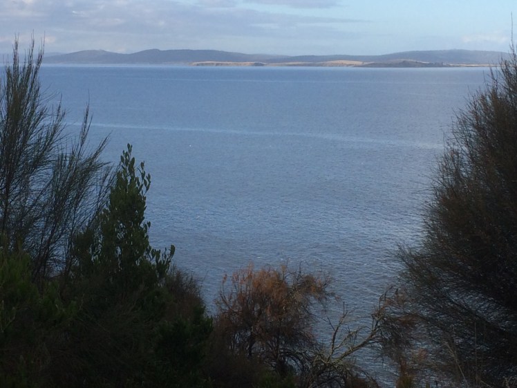
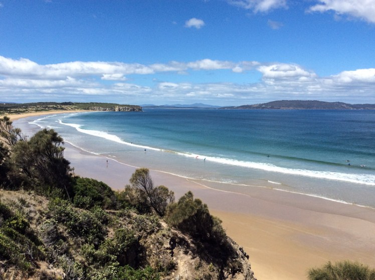
Clifton Beach and Pipe Clay Lagoon viewed from Cape Contrierity
Tiptoeing Along a Cliff Edge
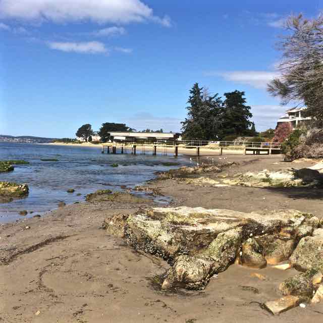
Zooming in with Google Earth I thought I spied a couple of small beaches north of Smugglers Cove and the light tracing of a path through what looked to be a nature reserve. It was enough to convince us that it was worth trying to tackle the cape from Clifton Beach on the northern side and so on a sunny day at low tide, while people swam between the flags and surfers lolled on their boards beyond the break Cathy and I scrutinised the dunes and the cliffs at the southern end of the beach and found a path that led up a steep gully. With an eye out for snakes, we scrambled up it, trusting our weight to the branches of a couple of conveniently located bushes.
There was a narrow strip at the top between the ‘keep out’ barbed wire fencing and casurinas rimming the high cliffs, some of which had fallen away. Peering over the edge we could see their broken pieces tumbled down against the sea.
We found a path, but it looked wallaby made and we meandered on and off it making a difficult passage over and under vegetation, sometimes trusting to the generosity of land owners by slipping over the fenceline to where the walking was easier. In one memorable spot, we had pretty well a foot wide space of sky we needed to cross. I avoided looking down. The drop was horrible, but Cathy skipped over it oblivious to Death’s outstretched hands.
Our tardy progress was made even slower because the views were compelling and so we’d stop, point out landmarks we were confident about and speculate about those we weren’t.
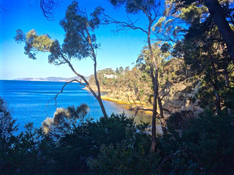
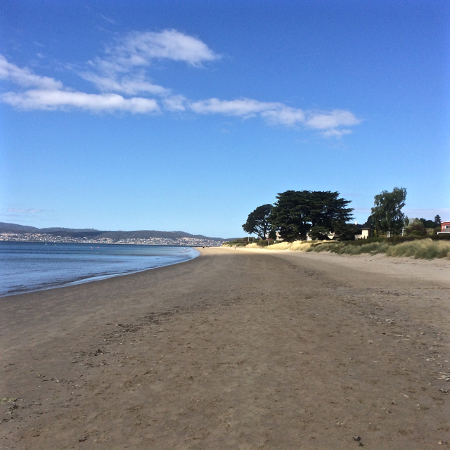
Clifton Beach and Cape Deslacs. Tasman Peninsula is visible across Frederick Henry Bay
We finally found ourselves on the far end of the casurina copse, gazing down a long slope of golden grass and up the slope on the other side. There was no clear path and it had the look of large expanses of private land. With a couple of households dotting the cape, we decided to avoid rebuke and reluctantly turned back, walking single file. Cathy quietly observed the tail of a snake disappearing down a hole between us, so we were pretty pleased to reach the beach unbitten, and as the day was still young and the beach glorious, we decided to take an amble to the cliffs below Cape Deslacs.
The interplay of land and water made the walk worthwhile
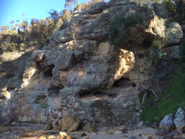
Not much has been written about this cape, but on Placenames Tasmania I discovered that D’Entrecasteaux had noted this name on his voyages of discovery and that it had another as well – Watsons Bluff. Watson was definitely no lady because it’s my observation that places get named after men, rarely women. No doubt he was merely an earlier landowner whose name buried earlier ones tangled with mythology,
I dug about on Trove as well and discovered a 2000 fisheries arrangement between the Commonwealth and Tasmania that referred to a shark nursery in the ‘area known as Frederick Henry Bay and Norfolk Bay being all waters within an imaginary straight line between North-West Head and Cape Contrariety’ and in an article on geology in the Sanford area, Green (1961) mentions dolerite intrusions into mudstone as well as landslips in the cape’s basalt soil. As he also mentions lavas here, this little cape has some complexity but keeps a low profile in the island’s literature.
Kingston has three beaches. Boronia, tucked away behind cliffs is the most southern one.
Looking back at Kingston Beach from the Boronia Point track
May 2015
‘It’s a nudist beach,’ someone told me.
‘We’ve kayaked past it,’ the geo said.
‘Heaps of sea dragons. Brilliant for scuba diving!’
Whatever, the beach was there and I wanted to explore it. On foot. Especially because of a blog post and what the ornithologists had told me long ago – and then, when the time came, I totally forgot the most interesting thing about Boronia Beach. I was too engrossed in the place itself.
I had already had an encounter with Boronia Point. One Saturday, as we milled around behind the starting line with the fleet of yachts in the long distance race, I was surprised to discover that one buoy would be off that point.
‘Where’s that?’ some of the crew wondered, and S rushed off to confirm it on the chart. I planned to take a good look at the beach as we laid the line to that buoy but a great gust of wind swept down the valley and gave us a whack right at the opportune moment. We heeled with remarkable swiftness. There were yells to reef along with the arrival of that particular intensity that sharpens focus when the mast leans down to kiss the water and it’s all action stations on board. That’s why I totally forgot to study the beach.
This day there was a lot of canine energy going on as we three urban explorers (two of us canine) headed off along the track, starting on Boronia Point behind the Kingston Sailing Club, where Boronia Hill descends down to the water. They pulled me along, at first along the cliff top path under gums and casuarina trees. There are paths and wooden steps leading down to the track from gardens and hill top roads, and there is a small wooden bridge. On this day music drifted out an open window. Someone was practising at their piano, and an elderly man sat on a bench where trees give way to a swathe of grass, absorbing the long views north over Kingston and Tyndall Beaches and across the river to the South Arm Peninsula. The river gleamed with patches of white foam and still water. (It’s worth mentioning that rather sadly the bushland of the point is separated by a thick strip of houses and roads from the lovely top of Boronia Hill where there are tracks through remnant dry sclerophyll forest and delicious views from a grouping of large lichen dappled boulders beneath the trees.)
Soon we arrived at a fence, a gate and a sign saying reserve; no dogs, not cats, no camping – and there we turned back. I’d known this would be the case and I didn’t mind at all. This track was a real find. It made me feel expansive. I was happy to walk it any time.
THE SECOND EXPEDITION
Snow was forecast and although the wild wind had calmed it wasn’t until I reached Kingborough that the sky turned blue. Again the beauty. Again the piano music . I had a vague notion of what to expect beyond the gate because I’d explored the point using Google Earth the previous night, seeking a connecting path to Blackmans Bay further south but it was still a surprise to find that quite quickly after the gate the path started to descend. There are cyprus pines, the small cove of Boronia Beach opens up and the cliff line comes into view. Honestly, my first thought was Mama Mia! This could be a beach on a Greek island. Clearly a conventional thought – I’ve now seen is described this way many times. (But the sky has to be blue. I brought my sister here one overcast day not so long ago and it felt uncharacteristically sombre.)
The great view east: South Arm Peninsula hiding Ralphs Bay from sightLooking south with the Tinderbox Peninsula in the distanceBoronia’s cliffs. Not short on character
Some of the beach was in shadow but I had it all to myself (not a nudist in sight) as I wandered around absorbing its serenity. I discovered a manmade rock wall, quite low, just where there’s a rock platform, and I praised the cliffs for their beauty but mostly I was trying to find a way to walk to Blackmans Bay along the rocks.
There’s a small overhang below these cliffs (which are themselves full of incipient caves) and a crevice which stopped my progress. No route south, it seems, but as I walked back through the clearing I saw I now had company. Two people were walking stealthily and silently across the slope, bending down periodically to peer at the ground with torches. On their advice, I took a path that led me through a small gate, past a tap and into someone’s garden. Dead end. I turned back and discovered they had gone. Next I tried the path that led directly up the hill. It emerged through another gate (a weakness for this reserve – two gates) and onto a long dirt road, rather beautiful.
This sign reads no dogs, no cats, no camping… and people! Shut the gate!Jindabyne Road above the beach. Pony trap and picnic basket required.
I met a man collecting armloads of eucalyptus bark in a paddock on the other side of the road and somewhere around here the Boronia Country House Hotel once stood. Curzona Allport sketched it. You can see this print and a couple of postcards at the State Library of Tasmania. Back in the early 1900s people liked to take the ferry that docked at the Kingston Beach jetty and visit this hotel for refreshments, just like at Crayfish Point. A garden with rhododendrums and dreamy views. But I was more conscious of the cyprus pines and the casurinas that had dropped curled tendrils all over the paths, the wallabies that scattered as I made my way along the paths and evidence of middens, testifying to a pleasantly sheltered spot to light a fire and enjoy the river’s bounty before ships began coming up the river.
Making like a swimming pool
Looking north up the Derwent River from Boronia Beach
It was only when I was heading home (through that first gate into this reserve – left open by the party of three I’d just past – that I remembered that the ornithologists had told me that Boronia Beach is the home of one of the last remaining rookeries of little penguins on the Derwent. Even the sight of that suspicious couple with their tiny torches, walking where, ethically, they should not have been, peering down burrows, risking putting their troublemaking feet right through them – even this had not triggered memory. But what I did remember more clearly was a blog post written by Mike Litzow, an Alaskan cruiser who liked visiting this beach with his family while living in Hobart for a year. Someone had not shut the gate, he wrote – and here I just have to say how sickened I am by how many gates to reserves along the Derwent I find left open. Who are these people??
I’m letting Mike tell the story of blood and carnage. His story testifies yet again to our great disconnect from nature. Here’s the link. It starts with the death of one little penguin, ends with the death of more than 20 and the comments are worth reading too.
The rookeries around the Derwent are very small and very endangered. At Boronia I’ve witnessed the gates left open, human feet trampling and, on my visit there earlier this month, people camping.
There’s a concrete path that curves around the southern edge of Long Beach and leads out past Blinking Billy Point to Blinking Billy Beach. When the South Westerly is churning up white caps on the river this path is sheltered and has a great view north across Long Beach and down to the bridge but once you step from the behind the shelter of the hill the wind is out to get you and its Antarctic breath can cause your eyes to stream.
The narrow way
Conversely, when the tide is high and waves are being hurried into the bay by an exuberant North Easterly, you may find yourself attacked by an encroaching wave and forced to turn back. Mostly, though, it’s a sunny light hearted sort of stroll, long enough to sniff the breeze but too short to regard as exercise.
The view north on the path to Blinking Billy Point
A friend had told me there was a Sandy Bay beach where dogs were welcome any time of day but her description was vague and I had struggled to find it. Then one day, coming back up river after a weekend of sailing in the D’Entrecasteaux Channel I noticed two labradors with their people on a stretch of sand I hadn’t paid attention to before, and recognition dawned. It’s now become a favourite walk when the dogs are keen to go adventuring and I can’t quite match their enthusiasm, or I want to catch up with a friend for a coffee and treat them too.
As with most of this coast, Blinking Billy Point has changed names like people change clothes. It used to be called One Tree Point until (I’m supposing) that lone tree was no more. It was also once called Garth’s Point.
The Garth’s came here from Norfolk Island with seven children in tow and made a quick segue from the merest of shelters to owners of two land grants, the one encompassing the point and the land uphill through what’s now the Alexander Battery Reserve, and the other spread across Porter Hill.
The Garth’s were farmers by day and smugglers by night. The submerged reef below the point was called Garth’s Bank and served two purposes: fishing and smugglers’ lookout. Further uphill on their smaller Porter Hill grant, they built their smugglers’ hut and it lasted until a fire burned it down in 1978. Devon and Cornwall can move over, I think, because Tassie has a rich smuggling history too.
One fine day when we were idling past the point on a light breeze someone mentioned that long ago William Watchorn, harbour master, a man with nervous eyes, lived on the point. He lobbied for a light and he got it. Both the point and the light assumed his nickname: Blinking Billy. The light still stands and while its gaze was fixed and unblinking in its time, it works no longer and is disregarded by river traffic.
This light was rendered useless by the John Garrow Light, a navigational structure, cormorant hang out and sometime racing mark, that took its place offshore on Garth reef. For some obscure reason this light is named after a pastry chef who lived in Bath Street (Battery Point) and the pastry chef’s name was extended to Garth reef as well. It’s now known as the John Garrow shoal.
Blinking Billy LightJohn Garrow Light
For a low, unassuming point, Blinking Billy Point carries a wealth of history and interesting buildings. Along with the navigation light there is the remains of the searchlight emplacement. Two spotlights, precursors to the Dark Mofo lights, but focussed on defence not entertainment, lit up the sky from 1890 to WWII, playing their role as part of the the Derwent Defence Network, which included, in this vicinity, the Alexandra Battery further up the hill and the artillery at Fort Nelson.
Old spotlight emplacement
There’s also an old part of the city’s sewage system – a small blue pumphouse which was built in 1919 and is deceptively pretty.
The pump house
People still cast a line over the smugglers’ reef on fine days, but those of us who sail know only too well the river’s violent mood swings and I’ve seen kayakers caught out here, just metres off the pointt, overturned and struggling to reach the shore.
Sources:
Nautical News: the newsletter of the Maritime Museum Association of Tasmania. Winter edition, 2002.
Goc, N. 1997. Sandy Bay: a social history, Gentrx Publishing, Hobart.
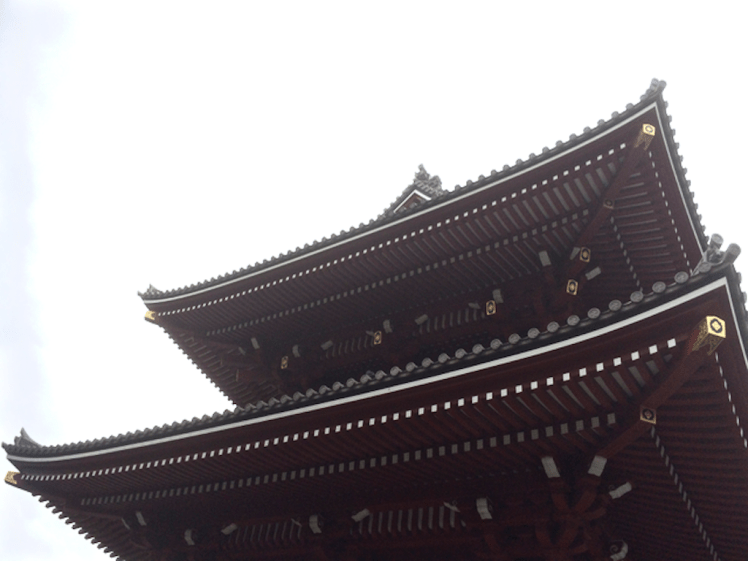
When someone you love says ‘Meet me in Tokyo,’ the temptation is just too great. I put my blog aside, abandoned social media and headed out into the world on a small adventure that involved food safaris, onsin challenges and meditative pilgrimages to shrines, both Shinto and Buddhist. In Kyoto the leaves were turning.
Sky Tree, the Asahi Flame and Sumida River
We took up residence for a while in Asakusa, an old part of Tokyo, where the Sky Tree towers over an already tall city and the Asahi flame, such as it is, lies heavily on its side beneath it. We were close to shrines, big and small, that honour the Bodhisattva Kannon who is intimately linked to the Sumida River. The story goes that back in 628 AD when the area was a delta, three fishermen hauled a statue of this particular Bodhisattva out of the river. The first shrine was made of straw. Now there’s a complex of wonderful shrines, including Tokyo’s biggest and most visited.
The gift of the Sumida River hasn’t saved it from all sorts of atrocities. It may know daylight but it has concrete hips. There’s minimal habitat for river species. The Derwent in comparison is a wild eyed hippie, a moody and creative artist with a flare for change.
I didn’t notice anyone fishing in the Sumida and barely a bird apart from a lone cormorant and a tiny flock of seagulls that flew into sight beneath a bridge. In fact, with a bridge literally every kilometre along its length there’s not much river traffic either because the bridges are so low.
Flying back into Hobart is a beautiful experience – that first riveting sighting of the mountain and that most magnificent of rivers, always so spectacularly stunning from the air, is riveting.
Once my feet were on the mountain and my eyes on the river, I felt reconnected to home, ready to curl my hand around the tiller, jump on my bike, lug my kayak down to the water or take another stroll along the coastline somewhere.
Nutgrove Beach with Sandy Bay Point at the far end.
Two beaches radiate from unassuming Sandy Bay Point: Nutgrove to the north and Long Beach to the south, with green and leafy Sandown Park fanning out behind the point. The Sandy Bay Sailing Club is prominent above the dunes. It, along with its parking area inhabit the dunes and the area behind them. Last summer a creative French traveller parked his colourful van here and settled in, just one of the travellers passing through in their camper vans, their tenures normally much briefer affairs.
The day I walked from Lords Beach to Sandy Bay Point I had Hobart’s early regattas and yacht races in mind along with that first horse race (see post on Nutgrove). In the early years of the colony Nutgrove was a wider beach and on this particular day I got a clue as to what it had once been like because as I walked around the Red Chapel cliffs and found the little cove the birds have been gifted I saw that everything about the beach was different. It was wider than I think I’ve ever seen it before and at Sandy Bay Point, where beach access at high tide is often not possible except over the fragile dunes, there was a surprisingly generous sweep of sand. I was so deeply absorbed in the past that it was almost unsettling that no horses hurtled around that corner as they did back in the early 1800s when local accents were different, dresses were long and riotous parties were a part of the regatta and racing celebrations – to the point that Sir John Franklin (of North West Passage fame and, locally, as the Governor) put a stop to the regattas below Government House because there was too much unruliness and litter. James Kelly, chair of the Regatta committee (who’d circumnavigated Van Diemen’s Land and discovered Port Davey), moved it to Chaffey’s Point (today’s Wrest Point). Mr Chaffey made a killing at his pub – and Sandy Bay Point featured more strongly in the races.
Wide enough to race horses
Sandy Point, back in the 1800s, had smuggling coves to the right of it and smuggling coves to the left. The little rivulets – Waimea, Maning and Lamberts, for example, provided access routes for getting smuggled grog up into the bush but the inns along the coastline were conveniently located for receiving rum and other spirits from the ships anchored offshore too.
One of these ships was the Thomas. One dark night in 1833 Captain Hanley anchored off Sandy Bay. He’d cut deals with the smugglers, so his pockets were full and likewise the longboats were all weighed down as the smugglers rowed back into the coves.
Later that night the Thomas went up in flames and the fire raging on the river lit up the sky, mesmerising those awake on shore and ‘looking almost splendid’ according to an onlooker. Hanley and three other crew members were the only ones on board at the time. They jumped into a longboat and set off for the shore but because the fire seemed contained to the stern they returned for another look, while two boats, the Mary and the Stakesby came slowly to their rescue. As they stood near the poop the fire reached the magazine and their was a massive explosion. In the little farm houses along the coast people asleep in their beds shot upright and got to experience an unanticipated fireworks night. Somehow the sailors escaped with their lives.
‘At eight o’ clock on the Sunday morning the dying Thomas was towed burning to nearby Sandy Bay Point where she grounded in about five feet of water and continued burning through the Sabbath with crowds flocking to Long Beach to view the spectacle. (Goc, 1997).
Suspicion over who’d started the fire swirled through the community and over the ensuing days what was left – casks of rum and casks of salt floated on the water, easy pickings for the opportunistic.
The Thomas stamped its presence on the point, predating the ‘boat park’ with its pirate ship in Sandown Park. In fact, in 1880 ‘H’ wrote ‘…anyone walking now along the beach at high water past Murdoch’s fence would hardly believe that the ship Thomas which was wilfully burnt about 1831, and was beached at Sandy Bay Point, was available to ramblers at low watermark. Many a time I have with my young companions mounted the ribs of the old ship, which stood on the sands, a place which to get at now would be in 20ft water.’
It’s a whodunnit without an answer. The fire may have been caused by a smuggler dissatisfied with his deal, a mutinous crew member or, for all we know, the captain himself.
Source: Goc, N. 1997. Sandy Bay: a social history. Gentrx Publishing, Hobart.
Sandy Bay Sailing ClubRounding Sandy Bay Point
Approaching Sandy Bay Point: the path over the eroding dunes
Prossers Restaurant: a prime position on Sandy Bay Point. Rocks shoring up the eroding beach, usually below waterThe Sandy Bay Point walkway to the beach
View of the Casino from the Royal Yacht Club of Tasmania
Puzzling over Sandy Bay’s earlier coastline I browsed books and clicked my way through archival images and concluded that for thousands of years Wrest Point had more delicate proportions. Before the Mouheenener were forced off their land in 1804 it would have been used as a landmark, a camping spot, a pantry and a kitchen, with Lamberts Rivulet on its northern side creating a diversity of plant and marine life – that is, if that rivulet hasn’t been diverted. I checked the stormwater map. Drains and rivulets join up but I was reasonably confident it was entering the river in much the same spot it always had.
People were possibly born on this point of land and they certainly died here, hung for misdemeanours on Gibbet Point, as it was known in the early days of settlement, because it was far enough away from Sullivan’s Cove not to cause offence but still a visible reminder of the ultimate punishment.
These days bitumen and the casino weigh down those old sorrows and more besides, because apparently the Sandy Bay Station was in this general vicinity, the home from 1838 of a cohort of homesick Canadian political prisoners, rebels in an uprising, the Battle of Prescott. Their voyage out from Quebec on the Buffalo took a hellish four months (sickness, injury, fear and hunger) and when they arrived, swaying and staggering on their sea legs, they were, that very day, forced off to build Sandy Bay Road. The station was rough – a circle of basic huts – and their provisions were meagre. But they managed to write diaries and when the Governor, Sir John Franklin, who later died searching for the North West Passage, came visiting, one of them wrote this:
He made a very edifying speech to us, in which he was pleased to say that we were very bad men, very bad, indeed; and intimated that we all deserved to be hung. He said we had been sent there for one of the most aggravating crimes, putting much emphasis on the word ‘aggravating’, and, at the same time, as if unwilling to look us in the face, rolled his eyes up to heaven, like a dying calf, if I may be allowed to use a a comparison suggested by my former business…’ (Captain Daniel Heustis, a butcher prior to exile).
Thomas Chaffey, who owned the point, tried to help them escape. He’d come out to the colony aged 45, having narrowly missed being hung for robbery and having served time on Norfolk Island. His land extended from the point up the slopes of Mount Nelson but he and his wife Maria (a Lady Juliana convict with a sentence for shoplifting) built a modest stringybark cottage on what then became known as Chaffey’s Point. The couple and their seven children had a front row view of executions for several years and after that a foul smelling try works may have been established on the point (Goc,1997). Thomas’s son, William, built the Traveller’s Rest hotel on Chaffey’s Point. Later, a hotel, the Wrest Point Riviera, was built there and in 1973 the Wrest Point casino took its place.
The Boardwalk at the Casino traps the sun and is built over the water. For a brief period one summer I liked to walk the local beaches then go there for a coffee, the papers and a view of the yachts. This was before we actually bought a boat and I could elevate that experience to coffee on board wherever on the river I chose to have it. (Today it was mid river, the water quiet, the breeze minimal and five dolphin in a tight pod swimming slowly by.)
The point has been the site of much happiness and sadness and these emotions are still very much entwined in terms of the current business of tourism and gambling. As for the land itself, it’s been beefed up, extended, and when you sail by you can see pipes entering the river beneath the casino as well. Although the cormorants and seagulls hang about on the rocks close by, the contamination from the hotel and the marina has to be detrimental. It’s no place for swimming and no place to feast on the stoic molluscs that survive there but apart from all that, it’s an iconic local landmark.


")