Tasman Peninsula: Lime Bay – Losing the Plot on Lagoon Beach

Lagoon Beach (T 343)

When a new friend said she felt like an all day walk I translated that into somewhere easy, somewhere short and somewhere straightforward because I had no time to plan  and I had a leg that had become the arena for lightning bolts of pain.  I figured we were sure to find a track that met these criteria on the Tasman Peninsula somewhere.

The peninsula was green and resplendent after rain and we were lured down the road to Lime Bay.  I’d camped there once, years ago, and expecting to see no one there we were amazed by all the tents, activity and music at the campground.

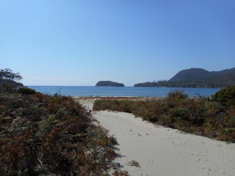
Sundra was immediately hungry and while she ate an early lunch I read the sign that described the route to Lagoon Beach, then returned to the  car to photograph the relevant pages of my guidebook.  Soon we were heading off along the hot track to Lagoon Beach through coastal scrub and beneath a shady canopy.  We were talking enthusiastically and were inattentive to our surroundings.  We paid little heed to the dry lagoon at the base of the palaeodune  we clambered up, but I did recall it from last time.  We did not look back to register our surroundings or to note the way we’d arrived on the beach, because coming over the top of the dunes we were enthralled by the view of the  sea and the  fingers of land all about us.  We should have brought bathers.

First view of Lagoon Beach
Lagoon Beach

Except for three couples sun baking and a yacht anchored in the lee of the southern headland the beach was empty and so, with no regard to the pages I’d photographed we walked south, thinking that a track might possibly take us over the southern headland. There, beneath the cliffs we found a wooden seat and a sand castle, and after eating a second lunch and admiring a couple of pied oystercatchers, our cursory search produced no evidence of a track, although I later discovered there is one.  And so we meandered slowly back up the beach, enjoying walking barefoot in the water.  And that, I felt, was enough of a walk for my grouchy leg.  Sundra, energetic and adventurous, felt the day had barely got started.

The couples were gone.  The marker she’d had the foresight to place in the sand where we’d entered the beach had been kidnapped by the rising tide.  For well over an hour we wandered up and down the dunes, trying to trace footsteps – anybody’s footsteps – that would return us to the track.  How weird to be lost on a beach, I thought, squinting at the pages I’d photographed to my phone.  I was pretty sure the best plan was to head directly back to camp and that if we headed for the trees we’d surely find the path, but our memories didn’t coincide.  Meandering about on the dunes we  had by now utterly confused ourselves, creating patterns of circuitous footsteps that now overlaid anything that had been there before.

Lagoon Beach
When everything starts looking the same

But at least there was wifi. ‘Lost,’ I texted back  home.

The pages I’d photographed were no help, especially when read with an increasingly distracted mind.  I did a Google search and found a helpful blog that talked about exiting the beach at the northern headland  with a picture helpfully included.  There was red tape up there.  If you followed it, it would take you across the headland (Green Head, apparently) to another smaller beach.  This blogger had then turned back.  Noting the sun’s position in the western sky I was all for turning back too.  I was still reasonably confident that if we returned to the forest behind the dry lake we’d easily reach the campground again.  A nightmare I’d had of being lost on the peninsula began to haunt me.

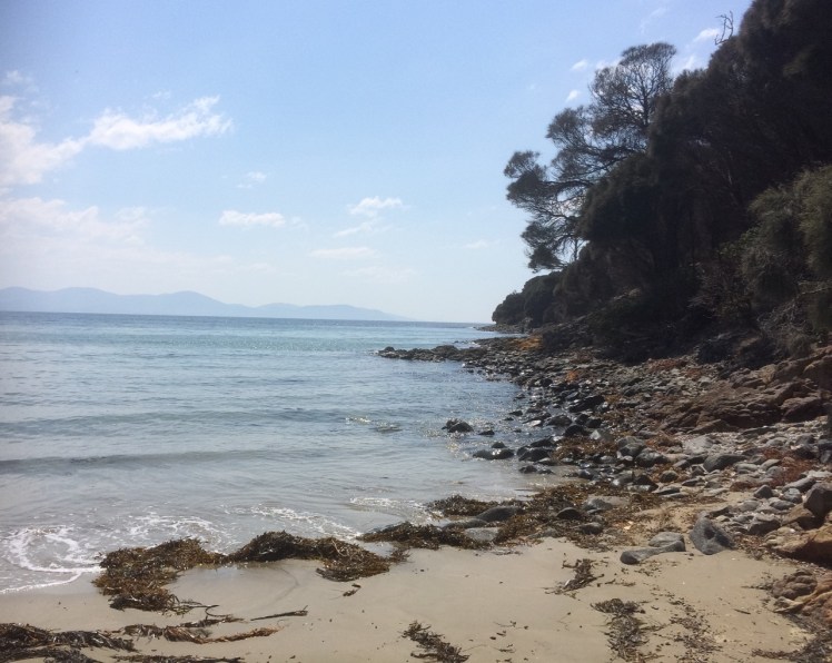
We returned to the northern headland we’d previously rejected as a possibility and scrambled up the steep slope that definitely did not look like it led to a path and after a bit of searching we found some red tape dangling from a branch.  We walked a little further and found just enough tape to keep taking us forwards.  We went down to explore the  beach referred to in the blog (Lagoon Beach North) and then went back up on the cliff again and followed the red tape until in the middle of nowhere no more tape was to be found.  From here the bays and inlets and fingers of land still confused me.  I had no idea what we were looking across the water at and thought that late in the day though it was, we were still better retreating than trusting to the traces of path that might be ahead.  Little did I know that the cliff tops here are shallow overhangs and considered dangerous (Leaman, 1999).

Sundra impressed me with her relaxed ‘ever onwards’ attitude.  When the red tape ceased again we ended up walking in different circles in search of  the oh so faint trail that often looked animal made.  It seemed that the trees our red bread crumbs had been attached to had relinquished their hold during storms of long ago or the tape had simply blown away in gales.

Lagoon Beach Walk.jpg
View from the cliff top

Keeping in visual contact with the shore while Sundra’s voice receded further away I tried to figure out our position on Memory Maps and Navionics and every other app I had available but nothing gave me the precise, localised information we needed – a clear track back to camp – a Lime Bay for Dummies kind of instruction.  I cursed myself for leaving the relevant map at home.

‘Still no idea where we are,’ I texted home, to the concerned enquiries.  No idea where Sundra was either.

The afternoon was softening into evening.  I suspected we would be sleeping out.  From somewhere far away Sundra called out.  Tramping around energetically, she’d found a tiny remnant of red tape, enough to lead us forward a little further but in what to me looked like an inauspicious direction.

Each tag seemed to take longer to find but we held on to a blind faith that we would arrive somewhere sometime.  On two or three more occasions we lost the  little red tapes seemingly forever and it was with some trepidation that we cut away from the cliffs to enter a thicker section of forest.  We walked downhill away from the coast and with a hefty sense of relief found at the bottom (incredibly, disbelievingly) the track we’d walked out along hours earlier.

There was the coastline we’d passed on our way to Lagoon Beach, one or two children still swimming in the water.  We had never been that far away we now realised.   I thought admiringly of sailors who navigate themselves across oceans.  I clearly couldn’t navigate myself across a pyrex bowl.  And I’m obviously imminently capable of getting lost in a backyard copse of trees.

Dadirri is an Aboriginal word for deep listening to others and to the landscape.  It’s used in both the Ngan’gikurunggurr and Ngen’giwumirri, languages from the Daly River region a couple of hundred kilometres south of Darwin.  Feeling lost in the bush, that still, quiet awareness was hard to come by that day.  Sundra had long ago finished her water and we were sharing the little I had left.     We had no GPS and the battery on my phone was getting low.

Dadirri  also refers to the awareness of ‘where you’ve come from, why you are here, where are you going now and where you belong.’ We’d done a lot of talking that day about just those topics.  I thought that night was likely to teach us about “the quiet stillness and the waiting” aspect of dadirri (Ungunmerr-Baumann)  and provide us with long hours to pick apart our mistakes.

Instead, as we travelled home after what had ended up being a six hour walk, we laughed as we reviewed the day and agreed that there was scope to do more walks together, perhaps with a bit more preparation.

But then again, without a map you really feel like you are more properly exploring!  (I am not recommending this though!)

If, one day, lost on Lagoon Beach, this is the blog you discover then be aware that the densely vegetated headland to the south is called Lobster Point and Sloping (Slopen) Main beach lies some distance away on the other side. The 1.6 km stretch of sand  that is Lagoon Beach lies in the lee of Sloping Island and it’s wise not go tramping about on the 15m high foredunes and their blowouts, particularly for their sakes. Take careful note of Sloping Lagoon which links the beach to the rear end of western Lime Bay beach.  There’s also a smaller lagoon at the northern end of the beach.

And perhaps, rather than following the disused and apparently closed track we were on – we did this walk in 2016 so this may have changed –  take your bike and go cycling around Lagoon Beach using these comprehensive notes on cycling in this area from Tassie Trails.

If geology is your thing there’s a dyke on Lobster Point and apparently on Green Head we were walking over all sorts of interesting volcanic and sedimentary geology which that day we were blind to.  Those dunes we came over – they’re interesting too. Grab a copy of Walk into History in Southern Tasmania by David Leaman and he’ll illuminate the geological wonders for you.  And go on the low tide – that way you can walk around the base of Green Head staying safer and not getting lost.


Forestier Peninsula: Lagoon Bay and Two Mile Beach, Bangor

Map Two Mile Beach Bangor
Map: Bangor, Forestier Peninsula  (Source:  Tasmap. Tasmanian map book: southern region, 2007)

Careful With Your Feet Now

Lagoon Bay Beach (Forestier Peninsula)

As I’d walked the Geography Bay beaches it had dawned on me that I was seeing very few birds. When I shared this observation with my friends most would think a little, then remember a couple of birds they’d seen on a rock the day before, or noticed on a beach they’d visited, or comment on seagulls that had been pesky down at the wharf.

This is very different from the year 1798, when Matthew Flinders estimated that there were at least one hundred million short tailed shearwaters within a single flock sighted in Bass Strait. They’re still Australia’s most common seabird but their numbers are nothing like that these days because of habitat loss and predation – especially by snakes and humans. (This Parks and Wildlife brochure explains more about these birds and their challenges.)

My friends’ answers perplexed me. I wondered if we’d normalised the low bird numbers we were seeing. Most of us don’t notice the loss of a particular birdsong from our garden because we don’t know the calls in the first place and we’re barely aware of our disruptive presence on birds when we wander along a beach.

One day earlier this year a notification arrived in my intray. Birdlife Tasmania was going on an expedition to Bangor, a well known farm on the Forestier Peninsula. There would be a beach walk and they’d be monitoring seabirds. I decided that this was a great opportunity to see a magnificent farm with 35 km of beaches and to learn more about shorebirds from those in the know.

And so I went along.

We were a group of about thirteen that hot day. A warm  wind was blowing from the north east and then, in the afternoon (when we were at Swan Lagoon) the sea breeze filled in as is its wont from the south east, bringing a refreshing change.

Matt Dunbabin, the owner, met us and filled us in on the history and environment of the farm, telling us about the damage sustained in the bushfire two years ago and then we set off in convoy, travelling slowly over the farm tracks beside water, across Blackman Plains and through dry sclerophyll forest. We stopped regularly, safari style, to observe birds, to listen to their calls against the backdrop of silence. I felt humbled by everyone’s enthusiasm and knowledge knowing my own to be pitiful.

We came to the airstrip. On a hill behind the headland forming the southern end of Lagoon Beach there was a small wooden house and between this headland and its northerly, forested neighbour, but hidden by scrub, lay Lagoon Beach. It’s possible to camp here and people were. In fact, they’d been coming here regularly for the past 30 years.

The beach was irresistible and while the group broke up and went off to various spots to observe birds I set off to walk it. I was dismayed by the extent of the litter. ‘It’s the worst we’ve seen here,’ said the campers, stopping on their way back up the beach to talk about it. ‘No doubt those storms we had brought this mess in.’  I went back to get some bags and soon the group from WildWays, also a part of the group that day, were also picking up litter.

The campers certainly had a point. There had been storms and in fact 2016 has brought odd weather to Tasmania. When I drafted  this blog post last summer, fires were still burning in the South West World Heritage Area and water storages had fallen beneath a mind boggling 12% through drought, mismanagement and a broken undersea cable that transports hydro electric energy to the mainland.  Then, astonishingly, the north of the state was beset not once but several times by extremely damaging floods.

I saw oyster catchers, Pacific gulls and two hooded plovers as I walked along, sticking as close as possible to the water’s edge. The tide was up and the sand was mostly quite soft. The endangered hooded plover, a tiny, well camouflaged bird that makes its nest in a barely noticeable scoop of sand, breeds here and is susceptible to being wiped out by misplaced human feet, the sniff of a dog or a storm event.

Bangor Lagoon Beach
Lagoon Bay beach

The beach was different from those I’d recently been walking. It was quite wide and apart from plastic bottles with Japanese print on them and other assorted plastic debris that hinted at fishing boats being the source,  I saw an abandoned eggshell that testified to a new bird somewhere in the vicinity. There was a heap of kelp and sometimes the bones of fish, bird and possibly a marsupial. Growing over much of the beach was a prostate, four petalled plant, which I tentatively identified as  sea rocket, a plant with an interesting back story. It seemed to be beach building, shaping the sand into slight dips and hollows and it was being thoroughly serviced by the bees – a bumble bee, honey bees and a small native bee were collecting nectar from its tiny flowers with quiet assiduity.

Bangor Lagoon Beach

There is a small rivulet at the southern end of this beach, running along the bottom of the hillside. The campers had noticed discoloured water around here and a bad smell.  Standing beside it I noticed a fairly empty Hills pesticide container (5l), the potential culprit. It seemed sadly ironic that this beach that would otherwise be so pristine, cared for as it is by environmentally aware owners, suffers, because of human carelessness, in this case probably coming from boats offshore.

It was on this beach that the difficulties posed for beach walkers by private land and rugged shorelines  really hit home. TheList indicates land tenure so that bit is easy. Identifying owners is not, so private land poses an access problem for those of us keen to access hidden beaches, headlands and rocky stretches.

Bangor Lagoon Beach sea rocket.jpg

PART TWO

Two Mile Beach (Forestier Peninsula)

Two Mile Beach Bangor - first peep

‘Two Mile Beach (T 299) is a gently curving 3 km long northeast-facing sandy beach located in 3 km wide North Bay … The bay is bordered by the prominent Cape Paul Lamanon and Monument Point in the north and 138 m high Cape Frederick Hendrick to the east. The beach receives refracted waves which average about 1 m at the shore and maintain a 50 m wide low tide terrace, cut by up to 12 rips during periods of higher waves. It is backed by a continuous foredune, which has a series of blowouts along the northern and central sections, some extending 200 m inland. The dunes are backed by 200 ha Top and Swan lagoons and associated partly drained wetlands, with Swan Lagoon draining out via a small creek at the southeastern end of the beach. Farmland borders and backs the lagoon, with vehicle access to Parrot Point at the southeastern end of the beach.’

Source: https://beachsafe.org.au/beach/tas/sorell/marion-bay/two-mile-beach

I regrouped with those bird watching near the campsite and we were reminded of the importance of not going up into the dunes because of breeding birds. More soberingly, I discovered that the breeding season extends over spring and summer. Human summer holidays happen at absolutely the wrong time of the year for the birds and as for me, I mused yet again about how best to limit beach walking to autumn and winter.

If we were a kinder, less self indulgent species we would quarantine beaches, or at least a goodly number, so that birds are still capable of breeding, nesting and fledging their young. Our presence on beaches is a huge reason for breeding failure.  There are beaches completely exempt to dogs or sometimes limited to particular times of the day but we put no restraints on ourselves.

About nine of us decided to walk up through the dry sclerophyll forest and down to Two Mile Beach. I had the most uncanny sense as we walked there of having been here before, on the wide track up through the forest, and I remembered how once long ago I’d gone with a keen birdwatching friend on a university ornithological weekend. Where the zoologists had placed a mist net back then had been so similar to where we were walking  that just possibly it was in fact the same spot, given that we’d also gone to count shorebirds at Marion Bay, not that far from here.

Two Mile Beach was a vast, impeccable curve of sand – an irresistible walk. Far away it curved and ran out to a point. You could see the surf breaking on the rocks. But we didn’t walk it. We sat on the rocks, some of us in shade, some in the bright, hot sun and ate our lunches and talked, and I discovered that the youngest two members of our group originated overseas – one from Nepal and one from Canada.

A ‘tin dish’ that had been bobbing out in the bay came and anchored close to where we were sitting and the sole occupant began scuba diving along the peaceful reef.

Two Mile Beach Bangor

As we began walking down the beach we noticed a few more things. Litter had been collected, and stockpiled in the corner. Fissure Island – it has a huge fissure separating its two sides one from the other – became visible around the headland.

Looking at the beach profile I think I figured out why dunes on this beach are also building and not receding. The kelp washes up. The sea rocket is nourished by it. It, in turn, nourishes secondary species, of which on this beach there was a profusion – the dunes were healthy and although marram grass was washing up it did not seem to be taking much hold… so many dunes around Tasmania have been damaged by the deliberate planting of marram grass, considered an asset back in the twentieth century.

In single file, out of respect for the birds, we walked carefully across the dunes to Swan Lagoon, brown and brackish. There were more bird species here – black swans, for one. There were  hooded plovers on this beach, some juveniles too, and we counted and identified dead shearwaters – mostly Fluttering Shearwaters, recent arrivals from NZ, I learned, and increasing in numbers, as well as fairy prions and a little penguin. A juvenile Pacific gull with a damaged wing walked ahead of us, doing a short glide each time we got too near. On the way back, as we approached the end of the beach and it feared being cornered, it took fright and managed a longer flight out onto the water where it sank down amongst some other gulls.

It arrived and they departed and I thought it must have drowned because I did not see it leave with them and doubted its strength to do so in any case, and soon there was no evidence of any bird at all on that clear blue water. This passed without comment.  My observation of declining bird numbers was taken as a given, the reasons well known.  We discussed loss of habitat in places like China – either before or after this expedition I heard a man weep on Radio National because of the almost total loss of habitat for migrating birds along China’s Yellow Sea coastline.  I was yet to experience the literally birdless skies I saw from the train as I traversed Asia and Europe by train and yet to read a report from Pakistan about the Indus Flyway (International Migratory Bird Route Number 4).

Again we sat on the rocks while the less heat tolerant members of our group ran across the sand and into the water for a skinny-dip – it was the kind of day and the sort of place that made a swim most compelling.

Bangor has a lovely restaurant, built  after the bushfire, but we were all so engrossed  in enjoying the lovely surroundings, both in and out of the water, on the beach and in the bush, that our progress out was slow and by the time we reached it, it was closing.  I made a note to come back some other time to sample the wine and enjoy the oysters, at that particular moment in time being devastated by POMS up and down the east coast, just another unusual event down here in Tasmania and linked perhaps to the East Australian current flowing so much further south than usual.

This slideshow requires JavaScript.

Slideshow:  Two Mile Beach and Swan Lagoon.