Derwent River: Tinderbox Beaches: Not the Real Fisherman’s Haul
Beaches T 471 (Fisherman’s Haul) & T472 Fisherman’s Haul South
Having scrutinised more maps I began to doubt that the Lucas Point Sewage Plant was actually at Lucas Point. It’s the landmark that helps identify Fisherman’s Haul and as conversations with locals had helped me fix it in my mind that it lay just south of Flowerpot Hill I started to think that the problem was one of language – ‘just’ is a stretchy kind of word for a start, and may not have been used by anyone I’d spoken to. It may simply have been a supposition I’d made from what had been said to me.
Our modus operandi was to drive along the Tinderbox road slowly (not difficult – there were quite a few cyclists out and about) and check for detours down the slope. The geo noticed a sizeable piece of green land with car tracks on it, somewhat sheltered from the road by a partial row of caesurinas. We did a u-turn and went back to investigate.
Close by a man was burning off. He ambled over to talk to me and I asked him if this was Lucas Point.
‘Some people think it is, but it isn’t really.’
‘Is it back where the sewerage plant is?’
‘Nope. Some people think that’s Lucas Point too, but it isn’t really.’
‘So where is the real Lucas Point?’
He pointed vaguely over his shoulder. ‘Back there a bit.’
‘Okay… And so I’m wondering, if Lucas Point is back there, then is this Fishermans Haul?’
‘Some people say it is but it isn’t really the real Fishermans Haul.’
‘Is there a beach down there?’
‘Nope.’
‘Is there a path down?’
‘Maybe. You should be okay if you’ve got your balancing shoes on.’
‘Well, thanks, I might go and explore.’
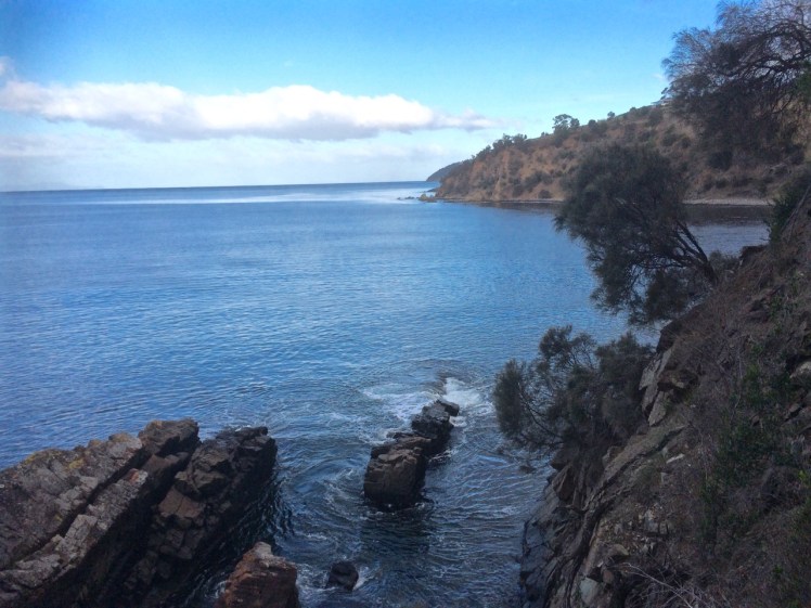
The geo was down at the bottom of the slope reading a sign. It stated ‘Lucas Point’. A thin band of caesurinas lined the vertical cliff top so we put the dogs on leads and slithered down a very steep path of sorts beside a short deep gully carved by another youthful rivulet, at that time dwelling soley in a few remnant pools. An old rusty cable lay beside the track but we couldn’t identify a use for it unless haulage came into it. It didn’t take at all long before we came to the end of the path. It stopped for me at a rather cracked and fragile looking rock arch left over from a previous coastline. It might have been fine to walk over it onto the high rocky platform but I didn’t like the look of the cracks in the unconsolidated cliff face to which it was attached. The geo and the dogs stopped a bit further back because it really wasn’t a place for the dogs to be at all – it was all rather precipitous.

It goes without saying that the long views were superlative. Down this end of the river we were getting closer views of the Iron Pot, the lighthouse at the entry to the Derwent River and in the southern curve of Lucas Point (the cliff I was presumably standing on) was a very beautiful and quiet cobbled beach and just to the north of where I was standing was another cobbled beach. Looking directly south at the cliffs that work around to Passage Point I saw a third. And looking directly down was a tiny narrow gulch.


Andrew Short notes a Fishermans Haul (S) and a Fishermans Haul. Here’s his description of Fisherman’s Haul:
‘Fishermans Haul is a small curving cobble beach (T 471) located to the lee of 40 m high Lucas Point. Steep vegetated bluffs rise to 50 m behind the small beach, which is partly sheltered by the point and rock reefs resulting in low waves at the shore. The road runs along the top of the bluff 100 m west of the beach with access via a steep descent. ‘(Short, 2006)
And here’s his description of Fishermans Haul South:
‘Beach T 472 commences 100 m south of the Haul, and is a 200 m long east- to northeast-facing narrow high tide cobble beach located at the base of 50 m high cliffs, with a steep gully descending to the centre of the beach.’ (Short, 2006)
New discoveries! Seen so often from the water but not really properly seen at all. I was happy to believe the sign and this time, added to the slippery geography I’ve been doing battle with, was that local’s wicked sense of humour and the entertainment he got from causing confusion.
This coastline may seem impossible to access on foot but later I discovered that it’s loved for being a climbing area rich in deepwater solos, that method of climbing that evolved in SW England. Nick Hancock makes it clear that for this you need a kayak you can tie up while you climb up dolerite boulders or columns at this point and you need to be confident that the water is deep and safe enough to splash down into. Don’t even think about trying this unless you have plenty of experience, not just about deepwater solos but weather conditions and the sea state too because Tinderbox is unforgiving. And if you think the name makes it promising for fishing, pack your tackle and take your rod further afield. Too many fish have been hauled and this area is now protected within the bounds of the Tinderbox Marine Reserve – no fishing allowed.