List of beaches
This page provides an outline, links to history and walks as well as a list of the South Arm beaches.

Overview
South Arm peninsula has a couple of islands just off its shore. Betsey Island and little Betsey Island lie at the entrance to Frederick Henry Bay and the much smaller Iron Pot (not demarcated on this map) is off Cape Direction further west. This is the waypoint that tells you, if you’re sailing, that you are now entering or leaving the Derwent River.
The peninsula begins at Lauderdale, a small town (locally regarded more as one of Hobart’s outer suburbs) in the Clarence Municipality that has as it’s distinctive feature a low lying isthmus separating Frederick Henry Bay from Ralphs Bay. It broadens out on the southern side and low lying hills, the tallest of which is Mount Augustus, stretch south along the Derwent River, with Ralphs Bay, a river embayment extending down the full extent of the peninsula.
On the eastern, more low lying side it just fails to fully enclose much smaller Pipeclay Lagoon, but Calverts Lagoon in the south, and smaller again, is totally trapped behind the dunes of Calverts Beach, its access to the ocean long gone.
Just below Collins Springs Hill (a source of water for the original inhabitants) the land narrows and turns west, diminishing into a slender isthmus that stops the Southern Ocean breaking through into the river at this point. One day when it does, this narrow land, like a bent and battered finger pointing north on the far side of the isthmus will be an island. At the moment, it’s the south eastern extent of the Derwent River.
Which makes the peninsula notable, because it is where the Derwent River, Storm Bay and Frederick Henry Bay meet, with another waterway, the D’Entrecasteaux combining with the river and Storm Bay directly opposite.
Even though it borders the Derwent River, the 2.5 km wide entry to Ralphs Bay between Gellibrand and Droughty Points creates a kind of separation from the rest of the river giving it a certain individuality. This is enhanced by the bridge like quality of the second isthmus in particular.
Lying in kunanyi’s rain shadow means that it is semi-arid with rather skimpy soils. It tends to be excluded from ‘must see’ places and this puzzles me. Firstly, it has popular beaches but it also has many more hidden from view that require more effort to locate. Secondly, it’s a varied environment – dune trapped lagoons, river, bay and ocean, dry sclerophyll forest and breathtaking views. Thirdly, less disturbed and having several points where different environments meet, it is richer in marine and birdlife than elsewhere on the Derwent. The South Arm Conservation Area helps protect that.
The two small communities of South Arm and Opossum Bay are on the far side of this second isthmus with its conservation area and there are some coastal walks such as the Tangara Trail, Arm End Loop and South Arm Peninsula Walk making this an interesting area to explore.
History.
A brief outline by the Friends of the Arm.
Walks:
1. South Arm Peninsula Trail: Information (Greater Hobart Trails – includes map). Bikes, dogs, prams all ok.
2. Arm End Loop: Walk information: (Clarence City Council – includes a map). Dogs ok. If you want to do this walk, do it soon! A golf course is planned for this area. According to the plan, it will become a ‘multi-use area’ but there’s valid concern about the impact it will have on natural values and recreation.
Beaches and Landmarks:
I’ve used Andrew Short’s 2006 report, Beaches of the Tasmanian Coast and Islands: a guide to their nature, characteristics, surf and safety (2006) as a guide for numbering the beaches. The numbering system is also used by Beachsafe who have placed the data from Short’s report online. The Nomenclature Board is tasked with officially naming beaches and since 2013 has had a policy of duel naming, acknowledging Aboriginal relationships with the land. But there are many beaches without names in Short’s report. Perhaps some have names known to locals, in which case please let me know.
The Gellibrand Point area / Arm End Loop Trail
This includes beaches T422-T427. See 20 July 2015 blog entry.
White Rock Transmitter station: landmark. White Rock marks the start of Opossum Bay and Mitchells Beach (see Opossum Bay) is the first of the Arm End beaches on the western side.
T423 South Mary Ann Beach
The next beach north of Mitchells Beach and 1 km south west of Gellibrand Point. It is a popular picnic anchorage for yachts because it is sheltered from the souther westerly wind. Access: Arm End Track. Facilities: None. More Info.
. 
T 424 : Gellibrand Point Beach. 150 m long, narrow and is west facing. More info.

Gellibrand Point: landmark, northern point of the South Arm Peninsula, southern point of the Ralphs Bay entrance.
Beaches to the east of Gellibrand Point on Ralphs Bay ~
T 425 : Spit Beach (North)
The Spit: landmark. Protected. No access. A bird refuge. There’s an anchorage in its lee but beware shallow water when entering and check the chart.

T 426: Spit Beach (South)
Both beaches look out over Ralphs Bay to Mortimer Bay on the northern side. The beach is composed of bands of shells, stones and sand and like other Ralphs Bay beaches is clear and shallow.
Access: The Arm Loop track that follows the western side of the point or more quickly (15-20 min) along the track from the northern end of Shelly Beach. Facilities: None. Dogs: No.
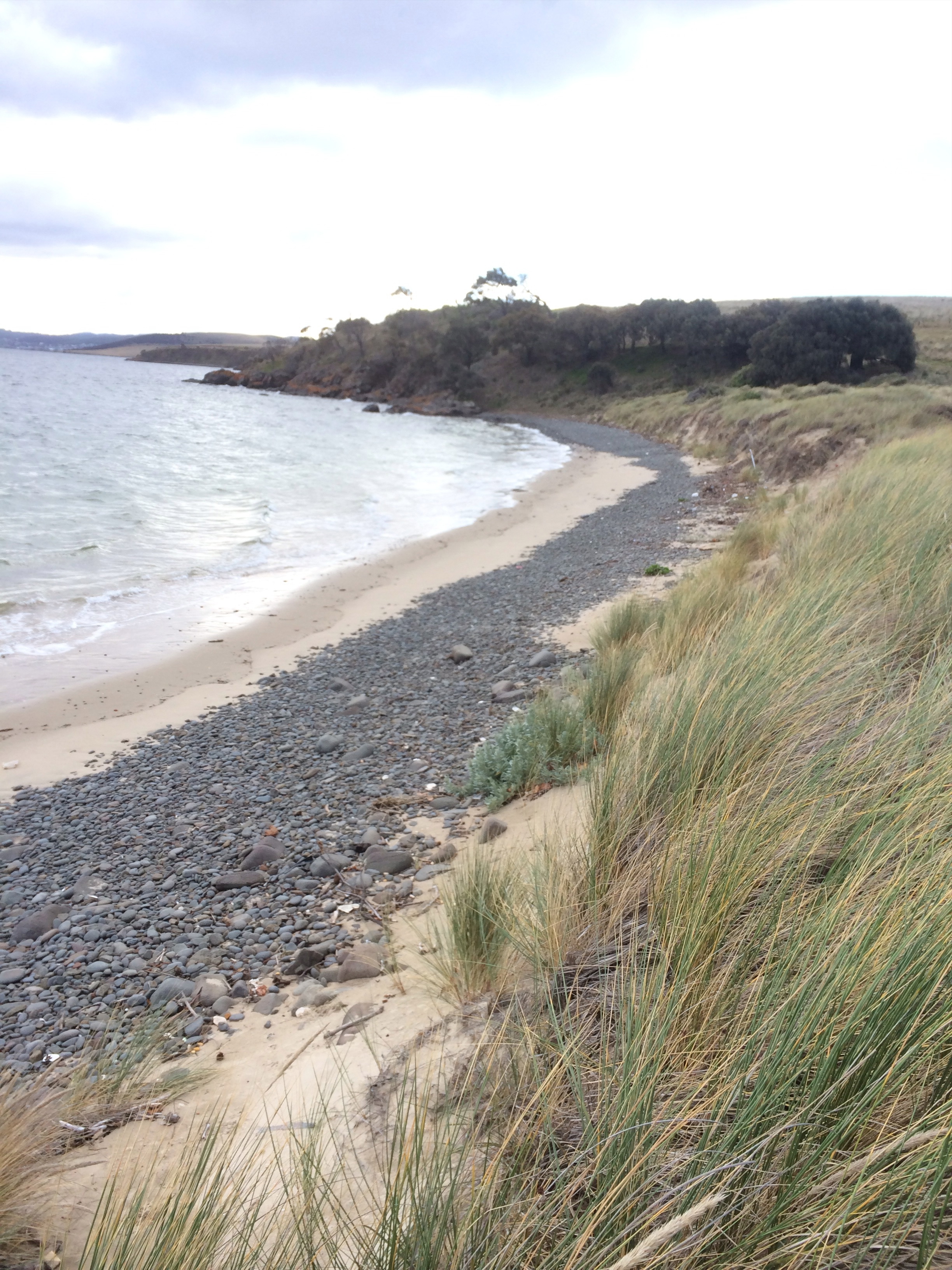
T 427: Shelly Beach.
1.5km south of Gellibrand Point, this 2 km long high tide beach is narrow with an interesting and extensive shell deposit in the small cliff/bank behind it, easily mistaken for a kitchen midden. It has clear, shallow water and Icehouse Bluff is to its south east. Grassy verge. Access: Via the Arm Loop track or at the Icehouse Bluff end of the beach through the tree line. Facilities: None.

Opossum Bay Beaches
There are three beaches in this bay:

T 422 Mitchells Beach
The most northerly of the three beaches, it is a curving low tide terrace beach with a distinctive band of cobbles beneath an eroding foredune and, if you follow the Arm End Track westwards, is the first beach you’ll encounter. The swell can be significant, so swimmers take care.
Access: There is informal parking at the end of Spitfarm Road. Take the walking track westwards and the beach is accessible down the dune but take care not to cause damage. The best approach is via Opossum Bay Beach – simply walk north around the small rocky headland. Facilities: None.
T421 Opossum Bay Beach
About 600 m long, this picturesque and sheltered beach on the Derwent River has houses and boat sheds that come right down the low bluff onto the sand and it’s popular with families. There is a jetty at the southern end.
Access: From the carpark off Spitfarm Road, a little way passed the shop. Facilities: Shop, toilets and children’s playground close by. Dogs: Yes, except between 10 am-6 pm Dec – March.
T420 Glenvar Beach
The smallest Opossum Bay beach, it is crescent shaped and is tucked between two headlands. Like Opossum Bay Beach, it is backed by houses.
Access: Turn left at the shop and there is a parking area off Pier Road. From here, walk left down the lanes and there is a path at lowest point of Gellibrand Lane. Alternatively, if you are up for adventure and have good mobility, work your way around the headland from Opossum Bay by way of the rocks on a low tide.
Facilities: Shop, playground and toilets shared with South Arm. There is also a boat ramp at the bottom of Pier Road. Dogs: Yes, lead only.
Blatherwick Rise
Landmark. The hill between Opossum and Half Moon Bays. The Pigeon Hole cliffs are a distinguishing feature and there is a short, unnamed beach tucked into this headland. It collects a fair amount of washed up plastic debris, so visit it with a bag and help to keep it clean. Blog
Half Moon Bay
South of Opossum Bay, this bay lies between Blatherwick Rise and Johns Point. It has three beaches and is a 3 km long bay that faces west across the Derwent Estuary.
T 419 Halfmoon Beach
This secluded beach at the northern end of the bay is bordered by Pigeon Holes and faces south. 150 m long, it ends in the south at a rock platform backed by a low point about 100m long.
Access: The same as for South Arm Beach’s northern access. If approaching via the coastal path leading north over Blatherwick Rise, walk down Algoma or Balema Streets. It is also possible to walk around from Pigeon Holes along the rock, if you have good mobility.
Dogs: No sign noted.
T 418 South Arm Beach
The longest beach in the bay, this crescent shaped beach is about 2 km in length and lies between Half Moon Beach to the north and Johns Point to the south. The small, South Arm community is located here in the south although houses back the beach further north too. Two particular features of this beach are the conifers on the dunes and the boat sheds on the beach. A good beach for swimming, walking and boating.
Access: From the carpark at South Arm, near the jetty and ramp. Accessible by tracks in other places and from the bottom of a couple of roads behind the northern part of the beach. Facilities: Shop and pharmacy. Dogs: Yes, under effective control. Dec-March not between 10 am and 6 pm.
T417 Johns Point / St Johns Beach
This 150 m South Arm beach lies beneath Johns Point, a 20 m high headland from which houses and shacks look out over the river and is the most southerly beach in this bay. Narrow, it is backed by cliffs. There are rocky platforms to explore and it is also a safe swimming beach.
Access: There are steps down to the beach from the Blessington Coastal Reserve and also from the southern end of South Arm Beach. Facilities: Shop and pharmacy. Dogs: On lead only.
More info | Blog
Seacroft Bay
Seacroft Bay lies between Cape Deliverance and Johns Point and faces west across the river. According to Short (2006), wave height averages less than 1 m inside the bay, increasing slightly towards Johns Point. northern half.
T416 Fort Beach
Just short of a km at 800m, this beach, the only one in Seacroft Bay, is backed by a low fore dune. There’s a playground and BBQ area as well as a car park. Houses overlook the beach from across the road, as well as on Johns Point at its northern extent, while the south is partially backed by Fort Direction. The beach is a southwest-facing reflective to low tide terrace beach, with a rocky outcrop more or less in the centre, and combined with either the cape and / or the point, makes for a pleasurable walk. It is popular with locals and is a safe swimming beach that’s also good for a picnic.
Access: Best access is from Blessington Road. Facilities: Car park, BBQ area, playground but no toilets. Dogs: On lead.
Pot Bay
Pot Bay is 500m long, faces south and has a single beach that is backed by Cape Direction.
T 415 Pot Bay Beach / Pot Boil Beach
Shorter than Fort Beach (it is 400m long), this beach is secluded and comes as a surprise if you don’t already know about its existence. Safest access route is via the walking path (approx 15-20 mins) from Fort Beach across Cape Deliverance. Dogs: On lead. (Rookeries in this vicinity; best to leave Fido at home.)
More info (same as above) | Blog
T 414 The Derwent River’s Final Beach
Secreted away at the foot of Cape Direction and surrounded by cliffs, this tiny 80 m long beach is the last beach on either side of the Derwent and is where the reef leading to the Iron Pot begins. Good mobility required; keep safe. Access it with care because the rocks require a degree of clambering and it is home to penguins and shearwaters. Take care around burrows.
Landmark: Iron Pot (island)
The lighthouse, originally Tasmania’s first, is automated now but the sandstone island, just 1.27 ha, part of the Betsey Island group, contains the remains of the light keeper’s home, as well as landing infrastructure. In The Mercury (10 Nov 1982) mention is made of a wild gale, of which there have been many. In this instance, waves broke over the lighthouse (35m above sea level) and carried off everything moveable, as well as destroying a rubble wall in their path.
The island is at the entrance to the Derwent, just off Cape Direction, south of Pots Bay. Seabirds breeding there include/have included Little Penguins (1 pair there in 1999), Pacific Gulls (also one pair at this date), Silver Gulls (by far the most numerous), Pied Oystercatchers (1 pair), Caspian terns (1 pair) and Black-faced Cormorants. (These numbers could very likely be out of date.)
Testifying to the fact that it was once inhabited, box thorn and lupins were, and may still be, a problem. Native vegetation includes pig face. More history here.
Source: Brothers et al (2001)
T415 Hope Beach
Landmark: Betsey Island and Little Betsey Island
Landmark: Goat’s Bluff
Ralphs Bay beaches
In Mortimer Bay:
T 433 Gorringes Beach
T 434 No name [Maria Point beach? There’s a shack with a large Keep Out sign behind the beach. Keep Out Beach?]
T 435 No name [China beach?]. There’s an historic tip behind the beach that spits out (sea) glass and china.
Landmark: Maria Point.
Huxleys-Richardsons Beaches
T 436 Maria Point (North)
T 437 Huxleys Beach
T 438: Richardsons Beach
Landmark: Haynes Point
Ralphs Bay North
T 438 Richardsons Beach
T 439 Lauderdale (W1)
T 440 Lauderdale (W2)
T 441 Rokeby Beach

What a resourceful website. Thanks for all you’ve created. My convict GG Granqdparents, John McLeod (died 1833) and his wife Mary, nee Potter (c. 1771-1837) lived at Maria Point on the South Arm of the Derwent River in and around 1825 and brought up 8 children there. John was a limeburner. He also ran a ferry boat from there.
Hi Robyn,
Thanks so much for taking the time to contact me. I love Maria Point and it sounds like you have a story to tell. If you’d like to write something up about your ancestors, I’d be keen to include it on this site. tasmanianbeaches@gmail.com will reach me.
I love the idea of No Name beaches! What a lift for those of us seeking quiet. Thanks for visiting.