When we were preparing the house for sale earlier this year, we moved on board Samos, thinking we’d be at Kettering in Little Oyster Cove for several months. We planned to spend that time cruising the D’Entrecasteaux and Norfolk Bay but within a matter of days our lovely mountain home had found itself new owners and we barely had time to tackle our list of boat tasks before we were home again packing boxes.
Travelling in a small van as we did last year and cruising in a small yacht proves that truism of life being richer as possessions get exfoliated and waste gets reduced. But moving house is not good for the environment. You may give the Red Cross Shop your library and St Vinnies the clothes off your back, but the recycling and refuse bins fill exponentially and zero waste targets shatter alarmingly.
We went down to the marina on a sunny day and stepping on board Samos I noticed a swirling black ring beneath the water, just behind the yacht’s transom, and an overlapping circle of silver, moving that little bit quicker. A cormorant was hunting a school of bait fish that panicked into a leaping confusion as the bird downed its catch while rising to the surface.
Relaxing beneath the boom tent with a g&t on a blue day before summer’s lease expired, we watched a puffer fish slowly inspecting the seaweed attached to the floating marina and each time the black swans came visiting the dogs were transfixed.
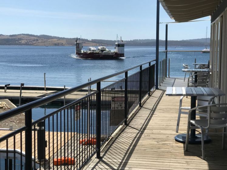
Life in the marina spools out slowly. Those of us working on our boats shared tools, suggestions, advice and meals while in the background yachts slipped quietly through the marina, the Bruny Island ferries came and went where once the Nuenonne paddled their bark canoes, where Bruni D’Entrecasteaux sailed – sealers and whalers too – and the constant sound on the boat, in the quieter moments and most noticeably in the silence of the night, was the idle clicking of tiny beings feasting on the hull.
The additional summer ferry crossing to Bruny Island from Kettering
The super blue blood moon rose over Bruny Island, the Channel and the yachts while the dark hills slept and we looked up at the moon and also down at its reflection, snagged in the riggings of yachts impressed by its light on the water.
There have been other times at the marina when nature has gifted us a surprise or two. We’ve been astonished by flocks of about 200 black cockatoos swirling around the pine trees. We’ve stopped to watch the parade of crabs along the marina shallows. Kayaking this cove I once followed a ray as it made its way around the north east corner. I like rays. The ones I have encountered all seem capable and full of purpose.
We were at the marina long enough to enjoy several coffees and breakfasts at the café beside the ferry terminal with its views of Bruny Island and to enjoy the pub up the hill. Really, the marina is for me the heart of Kettering and Kettering the link between mainland Tasmania and Bruny Island. For a small place it’s pretty amazing that along with the pub it has three cafes as well as artistic credentials and links, some believe to planets elsewhere. This extra terrestrial history inspired the Kettering Incident.
We walked the short track through coastal woodland around to Trial Bay, lazed at Kettering Point and in the evening took the short walking track below the cricket oval on the northern side of the cove. There are houses on the hills which were once entirely forested, that therefore drew timber cutters in Kettering’s early days, and tucked away in the valleys behind the village are farms producing organic produce for which Tasmania is rightly famous.
Marinas can be tough on the watery world but this one has achieved some recognition for its environmental efforts and living on board proved so enjoyable that we agreed that while small is beautiful if we want to live on board all summer long then a yacht a little bigger would be more comfortable. And so our lovely yacht Samos is on the market and a new adventure is about to begin.
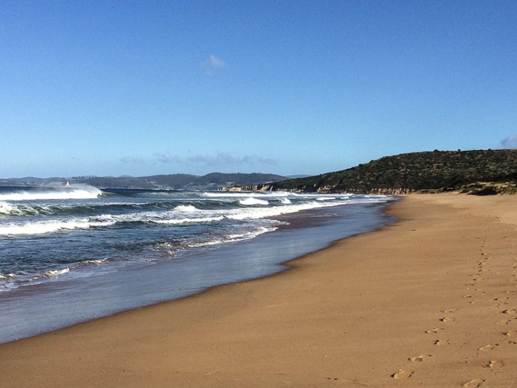
Hope Beach spreads itself from Cape Direction in the west to Goats Bluff in the east, a distance of about 5 km. It is backed by dunes that are quite large by Tasmanian standards. The beach forms the southern shoreline of the South Arm isthmus. Ralphs Bay is contained behind the dunes and this large embayment of the Derwent River provides a sheltered habitat for shorebirds.
Betsey Island lies offshore and between the island and the beach lies Black Jack Reef, notorious for snaffling the boats of the unwary.
Although we had come to Hope (driving through farmland then walking in along the dune top path) we weren’t sure we were done with Cape Direction. I stood beneath the cyprus pines that grow on the dunes in this western corner of the beach and contemplated its shaggy slope. Cathy energetically sought a path and although it was possible a way existed, the dense scrub made it uninviting. So we decided to tackle the rocks instead.
The reef at the base of the cape was an equally unlikely route around to Pot Bay but we gave it a go, timing breakers. It defeated us within metres but presented us with a great view westwards towards the Iron Pot Reef.
The Iron Pot from the Cape Direction rocks, western end of Hope Beach
As we set off along the sand a lone surfer stood on the dunes assessing the surf. A pied and sooty oystercatcher were chilling together, and later we spotted six more of the pied variety, along with a dozen hooded plovers – a great sight, given they are endangered.
Looking back along Hope Beach
It was only when we’d reached the eastern end (where the beach unexpectedly curves and broadens) and had climbed up Goats Bluff that we saw that those sand dunes, a bulwark against the ocean, were being sand mined.
Dune trapped lake behind Hope Beach with Cape Direction in the distance.
We could make out Black Jack Reef where one of the Incat ferries, Condor 11, ground to a halt on a trial run in 2011. But it is only the most recent shipwreck in this area. The best known one gave the beach its name.
The Loss of the Hope
The Hobart Colonial Times May 1827
We have the painful duty to report the loss of the barque Hope, which vessel was wrecked on Sunday morning last, on the long Sandy Beach, between Betsy and Iron-pot Islands. It appears she was on her way from Sydney hither, with about 100 tons of freight, and the following passengers: Ensign Barcley, 40th Regiment; Mrs. Bisbee and Mr. Bisbee (wife and brother of Mr. Bisbee of Hobart Town who came as passengers in the ship Elizabeth from England to Sydney); also Mrs. Westbrook mother of Dr. Westbrook. Of this place, another passenger per the Elizabeth, and three others, among whom is Mr. Edmund Johnson, nephew of Mr. Joseph Johnson of the Green Ponds.
The Hope made the Heads on Saturday afternoon; and took on board, off Cape Raoul, the pilot, Mr. Mansfield, the same evening, shortly before dusk. The Hope at this time was being towed in by two of the ship’s boats; but the pilot having taken charge of the vessel, told Captain Cunningham, that he could safely bring her up the river, without the assistance of the boats; from which, in consequence, she parted.
The Captain, however, wished the vessel might be towed in; but the Pilot observed, that his long experience in the river Derwent would enable him to bring her up in safety otherwise. The Captain was perfectly aware of sufficient room being afforded in the Derwent for any vessel to be brought up with almost any wind, and therefore acquiesced with the Pilot’s wishes; and, leaving the charge of the vessel in his hands, retired to rest, where he remained until awakened by the vessel running on shore.
The wind light and variable, and the vessel proceeded up the river but slowly. The night was rather dark and rainy; and about 4 o’clock on the morning of Sunday; about two hours before day break, she, by some means, we can scarcely conceive how, ran ashore, on the long sandy beach, in Shoal Bay, as above stated.
Although the night was rather dark, the wind was not violent, but the surf was running tremendously high. On the lead line being thrown, she was discovered to be in seven feet of water, while her proper draught was fifteen. The moment she struck, the consternation and terror became general; and the scene is described as truly terrific.
The Captain raving at the pilot like a man distracted, the latter standing in mute dismay— females just left their beds— sailors not knowing which way to turn, to relieve the creaking vessel, which was expected to go to pieces every moment, as she already leaked like a sieve— the heavy surf rolling over her, adding horror to the scene— while the dismal half hour guns of distress seemed to signal the death knell of all on board. Daylight at length appeared and discovered to the sufferers their truly perilous situation.
About 10 o’clock of the Sunday morning, two whale-boats, of Mr. Lucus’s fishing party, which had been laying off Bruny Island, came up to the wreck. They had heard the proceeding evening the signal-gun nfor the Pilot, which drew their attention and induced them to bend their steps thitherward.
They immediately lent their aid, with the ship’s jolly boat, in getting out the ship’s bower and kedge anchors; but the attempt proved fruitless, for one of the whaleboats (the property of Mr. Kelly), was stove, having her head absolutely dashed off, and the crew narrowly escaped with their lives. Captain Cunningham then jumped into the jolly boat alone, which parted from the other boat, and nearly fell a sacrifice to his eager promptitude, to save the vessel. Finding every other hope lost, to all the lives they could became their chief object.
The venerable Mrs. Westbrook and Mrs. Bisbee were safely conveyed on shore, after a state of most dreadful suspense for four hours. All this time, the rolling of the vessel almost precluded anyone from keeping their feet, while the state of the two females was most dreadful; overcome with weakness and terror, and fatigue, they could not stand without support, which was kindly afforded by a Mr. John Elliot and some other Gentlemen passengers. With the Ladies, Mr. Clarkson, charterer of the Hope, came up to Hobart Town by the whale-boat in the course of Sunday, bringing the fatal news to Town, leaving the other persons on board. Immediately on learning the fate of the Hope, the Agent (Mr. Behune), dispatched the sloop Recovery, a small craft, in order to bring away a portion of her cargo, in which she succeeded, having returned the following evening with as many tons of goods as could be thrown on board from the wreck.
But to return to the ship. On Sunday night, between 11 and 12 o’clock, the rudder gave way, and the upper part of her stern was driven in. At this critical hour of the night, it was every moment feared that the stern post would give way or be driven in also; in which case the vessel must soon afterwards have foundered, and every soul on board perished as the surf was still running mountains high. The other passengers who did not come up on Sunday safely arrived in Town on Tuesday – till which period all hands were employed at the pumps, in imminent peril, every moment in danger of being washed overboard. When some Gentlemen who left the wreck on Tuesday, who had visited it on Monday, the sea was gaining on the vessel every hour, her main mast had been cut away, and all hopes of saving her were given up. Some casks of spirits, which were on board, were ascertained to have been damaged by the salt water; and the tea and sugar, which also formed part of her cargo, must inevitably be destroyed. We understand, that among the persons who had merchandise on board is Mr. James Lord, owner of the Marquis of Lausdown.—- We are not aware whether the vessel is insured or not.
The government brig Prince Leopold, in coming from Maria Island with the remainder of the wreck of the Apollo, saw the Hope off the Heads on Saturday, and safely arrived in the Harbour the same evening. Monday she discharged her lading, and on Tuesday was immediately sent to the relief of the wrecked Hope.
There were rumours that £30,000 in silver coin had been buried on the beach by two soldiers. Captain John Laughton purchased the wreck at an auction, but in another nasty twist of fate he drowned while inspecting it (Shipwrecks of Tasmania).
The Bay of Fires from Humbug Point northwards is an exhilarating stretch of Tasmanian coastline. There’s just something about the white sand, the lichened granite boulders and the crystal clear water that combine to make it particularly awesome and peaceful at the same time. In summer, when it’s warm, the bush camping along The Gardens Road is the loveliest we’ve found in the state and in the cooler months there are plenty of beach houses available for hire.
Binalong is a small settlement on the northern slope of Humbug Hill, backed by a great reserve and with wonderful views. It has a tiny permanent population of about 200 people and is a mix of small shacks, large mansions and modest beach houses. There is no shop but there is a small cafe with a good menu and expansive views. Behind the bay and at the foot of the hill lies Grants Lagoon, wonderful for birdwatching or kayaking.
The complexity of the landscape – the casuarina forests, the photogenic rock formations and the dune trapped lagoons combine with the beaches to make this area totally compelling. Apart from cycling, swimming and kayaking, there’s a surf break at the northern end of Binalong Beach and at the southern end there are a number of beautiful coves separated from each other by massive boulders. There’s a gulch that forms a tiny harbour of sorts and these days an ecotour leaves from here and heads out by boat along the coastline as far north as Eddystone Lighthouse.
This spot hasn’t always been called Binalong Bay. It was once Boat Harbour but as there is also a Boat Harbour in the North West, it cast off name confusion and opted for something more indigenous. The Bay of Fires was known as Larapuna by the people these days known as the North East nation. There are believed to have been seven clans in all (Johnson & Mcfarlane, 2015) , roughly totalling about 500 people* who willingly granted seasonal access to the Ben Lomond nation, probably for reciprocal rights, enabling them to benefit from the area’s rich pickings. It was a meeting place and as the climate was mild, it could well have been where most Tasmanians chose to live in earlier periods of the Holocene.
The current name of the Bay of Fires was provided by Tobias Furneaux, who captained the HMS Adventure (part of Cook’s Great Antarctic Expedition of 1772-1775). He and his expeditioners noticed many campfires burning in this area at night, and aboriginal stone formations, seal traps, burial sites and middens still exist, so treading lightly and respectfully needs to go hand in hand with leisure and enjoyment when visiting this area.
After the European invasion, sheep farming, fishing, forestry and the transporting of these commodities grew in importance and on our last visit we discovered the tracks of what had once been a local railway. It follows a contour, then ends at the gulch, where today there’s a jetty and boat ramp.
We’ve been to the Bay of Fires three times this year. First we camped and then we brought some of our overseas family here. The mad keen cyclist promptly headed for the Blue Tiers track while the rest of us, being of more idle dispositions, merely rode from Binalong to the The Gardens, did a bit of Humbug Point exploring and had a pleasant amble along Binalong Bay Beach, the white sand soft underfoot.
It was only when we were at the farthest end of the beach where the big boulders begin, that we realised the cyclist had taken both sets of car keys. He was expecting us to meet him in Derby later on that particular day but his mobile had no Australian reception, so while he waited and wondered what had happened to us, we tried to relax into the knowledge that there was nowhere to go and nothing we could do except soak up the sun and admire the sublime view from the beach house.
The geo and I came back again shortly after our Hong Kong to London train trip. This time we focused on exploring with a little bit of kayaking thrown in for good measure. We met a local artist and had some long chats with a new friend who is walking the beaches from the Tamar to Freycinet.
Binalong Bay beach is a poignant beach for me. A good friend, who loved this spot too, had a heart attack on an early morning stroll along the sand and although he recovered, did not see out the year, dying on my birthday.
*Given the fact that European invasion of Tasmania caused numbers to collapse quickly and dramatically, this number is a best guess by some of those working in the field.
References:
Johnson, M & I. McFarlane. 2015. Van Diemen’s Land: an aboriginal history, UNSW Press, Sydney.
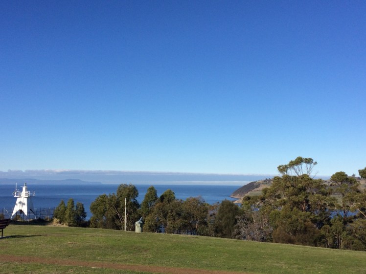
Piersons Point with the Tasman Peninsula in the distance and Bruny Island just across the water
Just because you’re a long way from an empire’s capital, with limitless miles between your island home and battlefields and just because a feud can begin and end in the space of time it takes to receive a letter doesn’t mean that you’re not going to get the jitters hanging out at the end of the world. So when GovernorLachlan Macquarie visited the Hobart Town settlement in 1811, his mind turned to the enemies that could arrive unannounced up the Derwent River – the French, for example, not that long ago defeated in the Napoleonic Wars. His perspective was military; the place clearly needed fortification, and so a network of batteries, some interlinked by means of tunnels, took shape along both the eastern and western shores of the river. I had long ago passed Alexandra Battery, which sits above Blinking Billy Point. The battery at Piersons Point is significant because along with Fort Direction on the far side of the river, it protected the river mouth (although it was a late comer to the system as it was actually only constructed and used during WWII). Prior to that time there was a pilot station here, at the junction between bay, river and channel and on fine days the family based at the Iron Pot lighthouse sometimes rowed across for a bit of conviviality.
When we’d arrived after our wander along this stretch of shoreline, there were some Sudanese children playing tennis on the court that seems as oddly placed here as the idea of a battery is now. Bruny Island is a short hop across the water, the river was to my left, the D’Entrecasteaux Channel flowing into it from my right, and Storm Bay spread south. I could look back down the long stretch of coast I had explored and across the river to Cape Direction and the Iron Pot light.
It had taken a bit of research but I now knew that the river was not only a drowned river valley but also a rift valley. I knew there was a bar beneath some 15m of water just north of Pierson’s Point and I knew that there was likewise a bar running from Piersons to Dennes Point on Bruny Island, because the depth instrument on Samos registers this as we sail over it. But the geo had also put me straight about the the river, the channel and their geological inter-relationship and his take is attached at the bottom of this entry.
It was ages since I had set out to explore beaches, yet here I was still in the Derwent. I had discovered parts of the shoreline I hadn’t really known existed. I had discovered it’s vague and sketchy nomenclature and I had discovered that it wasn’t supporting nearly as many birds as I had anticipated. I now knew these beaches were pocket beaches and that it’s pointless walking beaches without giving equal weight to the coastline in between and I had discovered that the means of travel impacts greatly on the experience. My most profound realisation had been that I was not nearly as hefted to the land as I had once thought I was.
I’d walked along Tinderbox’s spine but the road is narrow and while picturesque it can occasionally be at an unrewarding distance from the river. I knew I would cycle it one sunny day, but that’s more about a ribbon of bitumen than it is about the river and its beaches. I sail this coastline frequently, but then my attention is more on the boat’s interaction with wind and water. That being so, I felt I wouldn’t have done it to my liking unless I kayaked it too. I thought that in my kayak I could really acquaint myself with its rocky shore. And besides, hidden among those cliffs was, bizarrely, a secret door and I was keen to find it.
We set out the teapot and cups, then sat down and enjoyed a little tea ceremony to honour the Derwent. There were cumulus clouds in a blue sky. On such a stunning day, watching the ferry crossing the channel further south between Kettering on the Tasmanian mainland and Roberts Point on Bruny Island those old geographic anxieties seemed peculiar indeed. My geographical anxieties were of a far smaller scale than the governor’s. They were focussed on how I was going to co-ordinate my blog with the places I was intent on exploring. How to proceed, I was wondering. South down the Channel, and if so by what means? Or north from Sandy Bay through Battery Point and if so, how far up river? And if I mixed it up how would I keep a sense of continuity going in both my brain and on my blog?
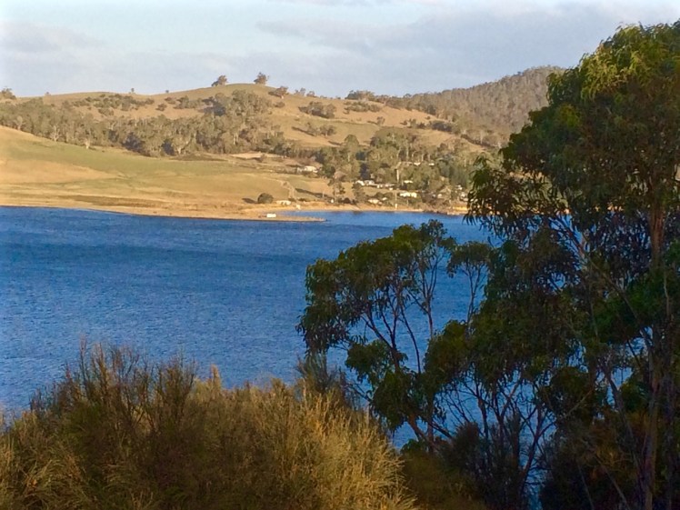
Looking across at Dennes Point, Bruny Island from Piersons Point.
Lacking the grace of an old lighthouse and looking more like something from outer space. Automated light at Piersons Point with the Iron Pot lighthousein the distance.
With a Dark and Stormy in one Hand and a Pencil in the Other
PASSAGE POINT
Passage Point is a notable promontary at the mouth of the Derwent Estuary and is both lovely from the water and green and pleasant from the road – a rolling hillside, a rustic shed, an abrupt cliff line carved by the waters of the Derwent, the D’Entrecasteaux and Storm Bay.
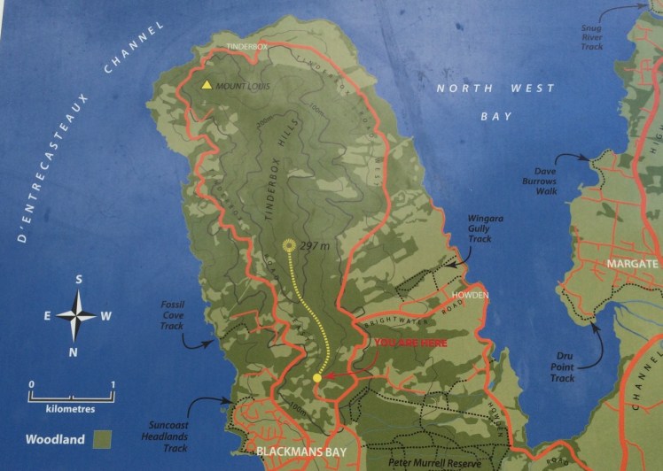
Map from the Kingborough Council Signage at the start of the Tinderbox Hills track: nomenclature is thinly used. Passage Point, Piersons Point and Tinderbox Beach, all important landmarks, are not noted. (Passage Point is to the left of Mount Louis.)
Having finally decided that ‘not the real Fishermans Haul’ was in fact the real Fishermans Haul (see last blog post), we went to Passage Point to see if there was some way we could access the little cobbled beach I’d noticed. There wasn’t. We had to make do with expansive views but as these were superlative and so vast in scope we could hardly complain. Mount Louis, Tinderbox’s highest point and forested in eucalypts rose behind us.
Birngana off Passage Point
My guess on how Passage Point got its name was all tied up with waypoints, landmarks and the ocean because if you’re heading off in your yacht on a trip of any distance, it pays to sit down and plan your passage. With a ‘dark and stormy’* in one hand, and a pencil in the other, take a careful note of the tides, currents and potential hazards. Become familiar with the landmarks you’ll pass, navigational signs you’ll encounter, channels or reefs you may need to negotiate and choose your waypoints. Make Meteye your new best friend and despite being in love with your chartplotter, tuck the paper version into your nav table too because it’s less likely to let you down. Departing the Derwent at this point to head out across Storm Bay is always a bit of a passage into the unknown because the bay is notorious for conjuring tempests up out of the most benign conditions.
Because this familiar promontary is just there where the waters of Storm Bay, the Derwent and the D’Entrecasteaux merge, it’s symbolic of passages about to begin and passages almost completed. So it goes without saying that this is how it got its name, right?
Wrong.
I checked Placenames Tasmania and found some unverified information. A boat called the Fancy was one of ‘the few remaining trading boats called passage boats.’ Back in slower more leisurely days these boats used to ply the Derwent and the Channel. In doing so, they had to round Passage Point and in so doing, they gave the point its name.
This information in the database comes from a boating article in the Saturday Mercury, Jan 2002 where it’s also noted that ‘most features on coasts were named by mariners and seeking reasons for names means looking at it [sic] from a mariner’s point of view. Thus Passage Point was a marker for south-bound boats of the entrance of ‘the passage’ or the Channel.’
Exploring the sweep of shoreline from Sandy Bay to Tinderbox had triggered my curiosity about the way places were named but I had not considered that mariners had a big hand in the names of the places I was exploring. This was an unforgiveable oversight because it’s obvious that many major features first got their names from the early voyages of discovery. My impression of the western shoreline of the Derwent was that places were usually named after the early landowner’s or overlooked in the naming process altogether but I could see that in a tiny colony at the end of the world there’d be a sense of familiarity and homeliness for locals who plied these waterways in naming the places they were passing by the names of the people they knew. On dark and stormy nights in particular, the ability to recognise familiar landmarks and tick off waypoints is comforting and engenders hope when you’re toughing out rugged conditions.
We paused here to savour the view. Passage Point felt extremely evocative for me: I had walked out one wintery morning and followed the Sandy Bay Rivulet down to its mouth. I had turned right and wandered the shoreline from there to here, a distance of some 35 kilometres, give or take a few and although I had done this as an urban explorer, little bit by little bit, it had been fun, it had changed the way I related to the coast as well as dramatically expanding my knowledge of the city I live in.
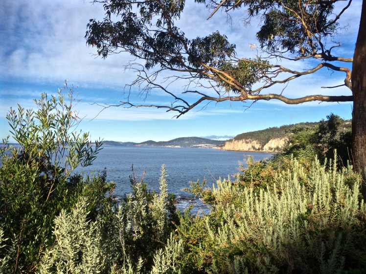
Looking north towardsHinsby Beach from the Alum Cliffs track
I had an assignation with Mr Brown’s River and so it seemed quite appropriate to invite him to accompany me, if only in mind, on the cliff top walk above the Alum Cliffs one day late last year.
That day I’d paused at the beginning of the track, surveying the view from a picnic table above the cliffs while chatting to locals, but mainly, I was quizzing Mr Brown, a drop out medical student from the University of Edinburgh who was thinking about all things floral while his fellow students focussed on cadavers, and whose enquiring mind and botanical obsession had, with a little help from Joseph Banks, brought him here aboard the Investigator in 1801, on Matthew Flinders expedition to discover whether New Holland was one island or many.
There was a breeze, I was ostensibly alone and a single yacht had the white capped river to itself as it headed up river just like the Investigator, which spent some time in the D’Entrecasteaux and the Derwent. Accordingly, Robert Brown spent a lot of time collecting plant specimens from Table Mount (aka kunanyi / Mount Wellington) and along the river, encountering and following the course of Brown’s River in the process. These are my tramping grounds, but on the voyage out he’d visited another of my favourite haunts – Cape Town, where he climbed Table Mountain several times and enjoyed botanising in the fynbos and across the surroundings slopes, including Devil’s Peak.
Defeated by the boulders below the cliffs (see previous blog) it was a whole lot easier rambling along a well formed path that often felt more bushland than clifftop as it wove through eucalypts (silver peppermint and blue gum) and banksias, past epacris in bold red flower, with the companionable little sounds of small birds calling. It’s a sunny and shadowed path with a faintly minty fragrance in places, that occasionally deposits one at the cliff edge for filtered views across to Trywork and Gorringes Points and the long vista through the gap into Ralphs Bay as well as north and south along the river’s two shores. The Iron Pot was visible out towards Storm Bay. I had no doubt that samples of the plants I was walking amongst were included in the 3000 specimens my companion collected and that made their way back to the UK on the very damp Investigator. A conversation between Robert Brown and Charles Darwin, I decided, would have been interesting. They were both lateral thinkers with acute observational skills of the natural world, including geology who spent time here that led to new insights.
Rock platform below the cliffs
These cliffs, where Bonnet Hill abruptly meets the estuary, are unstable and prone to collapsing into the river along their fractures and faults. They’re siliceous and weather from their greenish-grey to a far paler white, patterned with hues of oranges and lemons. Sometimes oxides and pyrites stain their fractures and as they’re composed of Fern Tree Permian siltstone they occasionally bear fossils. I sauntered over all this rich geology not much thinking about it except to wonder, as I walked by the junction of the Brickfields Track, whether the alum they hold ever found its way into the tanneries that used to line the Hobart Rivulet and made it whiffy back in the early years of settlement. Robert Brown came from Edinburgh, that cold city of stone and so it’s not surprising that geological samples, the substrate on which plants grow, and which moss, a favourite plant of his, is prone to nibble, were among his samples too.
I crossed three small rivulets by way of wooden bridges and passed a few other people out walking that day but otherwise had the friendly solitude of the forest all to myself until, quite unexpectedly, I was out of the forest and crossing a broad and sunny expanse of grassy reserve with lovely views from the bench down to the beach where people walked their dogs oblivious to the fact that they were being observed from up on high. I clambered down the steep steps to the beach. I had left Taroona behind and was now in Kingston, originally known as the Brown River Settlement.
Brown’s River, or Promenalinah, as it was named by the Aborigines who enjoyed its bounty before their lives were rudely disrupted, divides Kingston Beach into two shifting halves and although it’s really a single beach the northern section that has gone to the dogs in the best possible way (although shorebirds would disagree), is known as Tyndall Beach. This section is continuously shape shifting in the most beautiful way. There’s a small cove in the northernmost corner tucked behind a lovely rock formation, it is fringed by vegetation and eucalypts as opposed to the houses and shops along the main beach but we walk it with a heavy footstep and so there are few shorebirds.
Brown’s River (upstream)
Tyndall Beach looking north
After lingering at the cove, I chose the narrow path that winds through the strip of vegetation at the foot of the cliffs in deference to my companion. A fair number of his new discoveries from this area turned out to have been discovered already by La Billardière on D’Entrecasteaux’s 1792 expedition. The two men didn’t just have botany in common. Conversely, La Billardiere started off with botany but later qualified in medicine.
I crossed the casual parking area between park and beach. Time was against me but the northwesterly was due to swing south westerly so at least I’d have the wind at my back on the return walk. And so there I paused on the footbridge over Mr Brown’s River contemplating both it and the floodplain it has carved between Bonnet Hill and Boronia Point. The tannin in the river makes it whisky coloured. It rises on kunanyi and I’ve followed much of its course, from above Silver Falls, down to the estuary. It runs narrow and free down the slopes (although some of its water is detoured into Hobart’s water supply) and then it weaves through its floodplain.
Robert Brown found the river when Aborigines still camped here and enjoyed the river’s largess and the hunting to be had behind the beach. There’s still a remnant wetland and there’s still the remnant bush I’d walked through, but my eyes took in an urban landscape – houses smothering the floodplain, and houses on the surrounding hills with their gobsmacking views. Looking down from the Channel Highway, the clubhouse of the golfcourse is the Red House built by John Lucas way back when. He was a a member of the first settler family to acquire land here. They picked up several hundred acres of land around Brown’s River and it’s on this land that, in about 1808, Kingston began to take shape. (For a historical perspective see the photos below). He found other things to, being the first person to describe a living cell nucleus and observing the tiny random movements of miniature particles down his microscope. You learned about this in Biology. It’s named after him – Brownian motion.
I retraced my steps, trailing my companion but mingling with modern day locals using the track. With the arrival of the south westerly the river grew wilder and the forest canopy transformed into an orchestra of wind instruments. I hoped the trees would hold.
I once took a walk in Eastern Turkey with a friend. That path was the only link between two villages. It crossed a shallow river that my friend traversed on a donkey. There were caves where hermits had once meditated; the way we were walking was thousands of years old. The Alum Cliff track links Taroona and Kingston but it is purely recreational. It’s quite possible that Aboriginal feet originally made it but I don’t know this to be a fact. Even though these days the purpose of footpaths has diminished, in the same way that arriving at an anchorage by boat is so different in feeling from arriving by car, so is it different arriving at a well known destination by foot.
There are at least two suburban developments in Hobart that would have thrown Robert Brown into an apoplectic fit behind his desk in Joseph Banks’s library (he became its librarian). One is Tolmans Hill, completely natural not that long ago. The profound shock when the first house appeared up there! The dismay as the suburb grew. The other is the small enclave above Tyndall Beach that doesn’t really belong anywhere but has further eroded the landscape Robert Brown found so rich and strange. This used to be native bush but subdivisions continue to happen on Bonnet Hill and in the fullness of time the land still open land looks set to disappear.
Historic Photos of Brown’s River (Source: LINC Tasmania)
They were mine for paddling, and kayak along these cliffs I did, before discovering sailing and long before embarking on this humble little project. Now, standing on Hinsby Beach gazing south along their tall and shadowed extent, I wondered about the possibility of actually walking along their base. I’d once assumed the Alum Cliff track that begins at the bottom of Taronga Road on Bonnet Hill was the only way. Now I was not so sure.
Alum Cliffs from the path above Hinsby Beach
The coastline south from Hinsby Beach to Kingston is known as Alum Cliffs; the hill’s abrupt and perpendicular descent into the river. There is no beach at its feet, just rocks and boulders, as well as a rocky platform containing fossils beneath Taronga Road (a cul de sac that runs from the Channel Highway down to the edge of the cliffs not too far north of the point where the highway – in reality a narrow semi rural road – begins descending down to Kingston Beach).
Rocky platform, Alum Cliffs
I knew about this fossilised platform from chats with locals on Hinsby Beach and from Sue Mount’s article. They said that once it was possible to reach it on foot but a local landholder had built a fence that now excluded the public. Did they mean from their beach, or, in hindsight, did they misunderstand me and mean from Taronga Road? Exactly how you accessed this platform wasn’t too clear but I was determined to try.
Many years ago, when I was deeply into archaeology I walked the Brickfields Track (also accessed on Bonnet Hill) with the Tasmanian Archaeology Society. The Taronga Road area has mudstone, dolerite and a patch of quality sandstone along its ridge and is strewn with evidence of early colonial activities.
On that walk we came across remnants of the Brown’s River Probation Station (1840s) where over three hundred predominantly road building convicts once lived. There were the remains of a kiln used for brickmaking. Bits of the station are scattered through local gardens now and there’s a house with a swimming pool built into the old quarry. As the years have unfolded some of the bricks once part of structures or left lying about have been removed and incorporated into new structures or lost altogether. Some have no doubt ended up in the river. On my earlier walks I’d encounter red bricks remoulded into satisfyingly round and textured shapes by water.
On the Channel Highway, close to Taronga Road, there is still evidence of an old convict built wall. Some of that high quality sandstone (by Tasmanian standards) from the Taronga Ridge became the Shot Tower, locally famous for being the last remaining circular standstone shot tower in the world, built in 1870, almost twenty years after the probation station had become redundant. It, too, eventually became redundant but in its heyday was used for producing lead shot.
Kayaking, you can get much closer to the cliffs than when you’re on a yacht, although it can be unpleasant when the waves rebound strongly off them. On a yacht it’s best to leave a little seaway, especially along a lee shore, and when I pass by Alum Cliffs these days I’m usually sailing, observing these dark cliffs rising from the water, more wildness in the city precincts, topped as they are by communities of trees and shrubs forming a satisfying stretch of bushland.
There was a strong north westerly wind blowing on the first day I first set off to uncover a route along the cliffs from Taroona itself and I was feeling uncharacteristically despondent, in need of an activity to blast that mood away. Sue Mount’s article seemed to be a hint that the Alum Cliffs track had once started at the right of way onto the beach at lllawong Crescent. I’d looked at other brochures and I’d looked on Google Maps. None of them show it starting at this point.
But still I searched. I returned to the start of the Hinsby Beach track at Wendell Crescent. I walked down it and saw that there was in fact a path to the right that went along the very edge of the cliff, somewhat steep and slippery. I got as far as a patch of escaped daisies from the garden above. They were growing over the track and to proceed I had to grab hold of vegetation to pull myself upward. It wasn’t clear that the path continued on the other side so I decided that as I was alone and the path a tenuous, unused one so hazardously close to the edge, I’d best go up to Taronga Road and see if I could meet up with it by heading north.
I was enthused by the discovery that I could indeed head north to Taroona on the Alum Cliff track but I was not far along it when I met a local walking her dog, one like Ash, and so we got talking. She confirmed what I had already learned: that once it had been possible to take a path down to a large rock platform at the base of the cliffs hereabout and continue along towards Taroona, but it had been closed off by a landowner. If I continued along this path I’d reach the Shot Tower.
‘And it’s steep,’ said a man I encountered a little further along, and he was right. I came to a point where I had a clear view of the path heading downhill and then up the other side. My focus is on beaches and the stretches of coastline between them, and with these beaches it’s on the river itself, particularly (but not only) where it interfaces the land.
I declined the path’s feeble invitation and turned back.
On the rocks below Alum Cliffs
This was back in June 2015. Since then, I’ve gone back to Hinsby Beach on five or six separate occasions, all on the most promising of low tides, sometimes in winter but also at the supermoon’s low last month (9 March), when, unfortunately, the seabreeze worked against me, hurling waves at my knees in a quite malicious fashion as I tried to negotiate a watery gap in the rocks close – very close, I feel – to the little turn the cliffs take as they head to the area beneath Taronga Road. You’ve no business to be here, I felt they were saying. You people have made your track, now walk it.
But that day beneath the supermoon, I sat for a long time enjoying my splendid isolation, looking back towards Hinsby Beach, marvelling at seeing the cliffs with so much more of their base exposed, and enjoying their powerful presence at my back. They are not the only cliffs in the world. They are not even spectacularly tall but all the silence of the ages they contain gives them an undeniable aura in which I basked while deciding that, feeling personally rejected by the cliffs and the river, reaching the rocky platform and climbing up to Taronga Road wasn’t going to happen. The track above the cliffs is there for a purpose, I could only agree, and it affords a different vantage point from my watery stamping grounds. I decided with regret that I’d be satisfied with that.
Dropstone and periwinkles
The rocks below Alum Cliffs
And so that walk along the top of the Alum Cliffs from Taroona to Kingston is the subject of my next entry.
Sometimes you just don’t see what’s in front of your eyes.
The cardboard sign at the start of the track gave me pause for thought ‘Snake Spotted Lying on the Path’ someone had written, and so instead of exploring new territory I headed down to the marina to do a bit of work on Samos. The dogs lay and watched me. It’s currently the summer solstice, the day was hot, the moon a waxing gibbous and the tide low but oblivious to all this I was tending the engine and talking to my neighbour.
At a certain point I looked past the yachts and ducks to the houses that occupy the foreshore.
There at their base were remnants of beach. Rather sorry looking remnants but large enough patches of polluted sand to provide private coves for those lucky enough to live in those houses. Not that long ago it was a longer stretch of cleaner sand and boats swung at their moorings in the lee of Wrest Point. Now the marina’s been extended and there are new floating berths.
This view has become so familiar to me but in failing to question it I hadn’t seen it for what it really was: a beach still present enough to make a statement: well may I go unnoticed but I’ll be back in one guise or another long after the marina and these activities are gone.
There’s a concrete path that curves around the southern edge of Long Beach and leads out past Blinking Billy Point to Blinking Billy Beach. When the South Westerly is churning up white caps on the river this path is sheltered and has a great view north across Long Beach and down to the bridge but once you step from the behind the shelter of the hill the wind is out to get you and its Antarctic breath can cause your eyes to stream.
The narrow way
Conversely, when the tide is high and waves are being hurried into the bay by an exuberant North Easterly, you may find yourself attacked by an encroaching wave and forced to turn back. Mostly, though, it’s a sunny light hearted sort of stroll, long enough to sniff the breeze but too short to regard as exercise.
The view north on the path to Blinking Billy Point
A friend had told me there was a Sandy Bay beach where dogs were welcome any time of day but her description was vague and I had struggled to find it. Then one day, coming back up river after a weekend of sailing in the D’Entrecasteaux Channel I noticed two labradors with their people on a stretch of sand I hadn’t paid attention to before, and recognition dawned. It’s now become a favourite walk when the dogs are keen to go adventuring and I can’t quite match their enthusiasm, or I want to catch up with a friend for a coffee and treat them too.
As with most of this coast, Blinking Billy Point has changed names like people change clothes. It used to be called One Tree Point until (I’m supposing) that lone tree was no more. It was also once called Garth’s Point.
The Garth’s came here from Norfolk Island with seven children in tow and made a quick segue from the merest of shelters to owners of two land grants, the one encompassing the point and the land uphill through what’s now the Alexander Battery Reserve, and the other spread across Porter Hill.
The Garth’s were farmers by day and smugglers by night. The submerged reef below the point was called Garth’s Bank and served two purposes: fishing and smugglers’ lookout. Further uphill on their smaller Porter Hill grant, they built their smugglers’ hut and it lasted until a fire burned it down in 1978. Devon and Cornwall can move over, I think, because Tassie has a rich smuggling history too.
One fine day when we were idling past the point on a light breeze someone mentioned that long ago William Watchorn, harbour master, a man with nervous eyes, lived on the point. He lobbied for a light and he got it. Both the point and the light assumed his nickname: Blinking Billy. The light still stands and while its gaze was fixed and unblinking in its time, it works no longer and is disregarded by river traffic.
This light was rendered useless by the John Garrow Light, a navigational structure, cormorant hang out and sometime racing mark, that took its place offshore on Garth reef. For some obscure reason this light is named after a pastry chef who lived in Bath Street (Battery Point) and the pastry chef’s name was extended to Garth reef as well. It’s now known as the John Garrow shoal.
Blinking Billy LightJohn Garrow Light
For a low, unassuming point, Blinking Billy Point carries a wealth of history and interesting buildings. Along with the navigation light there is the remains of the searchlight emplacement. Two spotlights, precursors to the Dark Mofo lights, but focussed on defence not entertainment, lit up the sky from 1890 to WWII, playing their role as part of the the Derwent Defence Network, which included, in this vicinity, the Alexandra Battery further up the hill and the artillery at Fort Nelson.
Old spotlight emplacement
There’s also an old part of the city’s sewage system – a small blue pumphouse which was built in 1919 and is deceptively pretty.
The pump house
People still cast a line over the smugglers’ reef on fine days, but those of us who sail know only too well the river’s violent mood swings and I’ve seen kayakers caught out here, just metres off the pointt, overturned and struggling to reach the shore.
Sources:
Nautical News: the newsletter of the Maritime Museum Association of Tasmania. Winter edition, 2002.
Goc, N. 1997. Sandy Bay: a social history, Gentrx Publishing, Hobart.
When someone you love says ‘Meet me in Tokyo,’ the temptation is just too great. I put my blog aside, abandoned social media and headed out into the world on a small adventure that involved food safaris, onsin challenges and meditative pilgrimages to shrines, both Shinto and Buddhist. In Kyoto the leaves were turning.
Sky Tree, the Asahi Flame and Sumida River
We took up residence for a while in Asakusa, an old part of Tokyo, where the Sky Tree towers over an already tall city and the Asahi flame, such as it is, lies heavily on its side beneath it. We were close to shrines, big and small, that honour the Bodhisattva Kannon who is intimately linked to the Sumida River. The story goes that back in 628 AD when the area was a delta, three fishermen hauled a statue of this particular Bodhisattva out of the river. The first shrine was made of straw. Now there’s a complex of wonderful shrines, including Tokyo’s biggest and most visited.
The gift of the Sumida River hasn’t saved it from all sorts of atrocities. It may know daylight but it has concrete hips. There’s minimal habitat for river species. The Derwent in comparison is a wild eyed hippie, a moody and creative artist with a flare for change.
I didn’t notice anyone fishing in the Sumida and barely a bird apart from a lone cormorant and a tiny flock of seagulls that flew into sight beneath a bridge. In fact, with a bridge literally every kilometre along its length there’s not much river traffic either because the bridges are so low.
Flying back into Hobart is a beautiful experience – that first riveting sighting of the mountain and that most magnificent of rivers, always so spectacularly stunning from the air, is riveting.
Once my feet were on the mountain and my eyes on the river, I felt reconnected to home, ready to curl my hand around the tiller, jump on my bike, lug my kayak down to the water or take another stroll along the coastline somewhere.