
Bays of Dismay 1: North West Tasmania – Cowrie Point, Sawyer Bay
COWRIE POINT
Beaches T 996-998 (Short, 2006)
Embedded map:
Once, several years ago, bound for Stanley across Sawyer Bay, an open, 25 kilometre long coastline, I sailed passed Port Latta in a fast diminishing gap between gales. While the skipper took waves in her face with the broadest of grins, my friend and I tucked up under the dodger and watched the coastline go by. I was identifying old landmarks I hadn’t seen in a while – Rocky Cape, where this bay begins, and then the long jetty of Port Latta. Behind that jetty there’s Australian Bulk Mineral’s large, grey processing plant that belches smoke and in its shadow there’s a cluster of houses. Looking at them from out at sea, I felt for the people who had to live there and knocked it off my bucket list.
***
The holiday home had a couple of books on local history and an outstanding view along the coastline of the bay all the way to the volcanic neck that is The Nut, standing elevated above the landscape at Stanley, but I had not realised until we arrived that Cowrie Point was the site of those homes I’d looked at through the rain from that bucking yacht all those years before.
I went down to the inviting beach to stick my feet into Bass Strait’s waters. The high tide had piled seaweed high along the wrackline and the beach was backed by both feral and native plants over to my right. The rocky platforms of what I took to be a point, and the pebbles that I found, were unexpectedly stunning. They looked like agate with volcanic intrusions but when the geo went to take a look he said no, they’re Precambrian sediments with iron oxide deposits in the joints and sometimes in the bedding plates. There were stratigraphies laid on their side with sharp edges, long thin columns with longitudinal jointing, tessellations, pale colours, burnt ochres, swirls and speckles. Neptune’s necklace flourished in some of the rock pools but others seemed entirely empty. Cowrie Point, he said, was actually a tombolo.
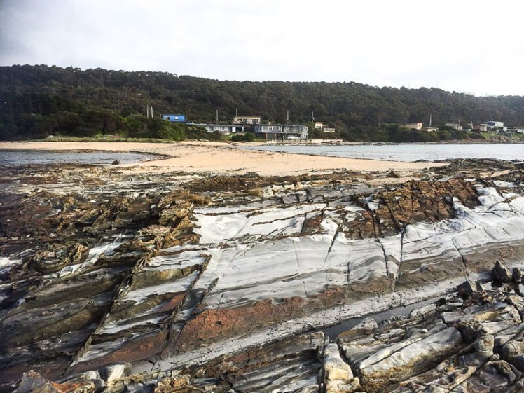
On the eastern side of the tombolo I found another beach (T 997), this time a half crescent curve of about 100m, rather narrow, that backed onto the beach I’d just come from. Again, but that bit closer, there was a view of the jetty and the looming plant, the white smoke dense in the sky, sitting improbably with the lovely proportions of the quiet beaches. Occasionally there was a low industrial rumble.
Just passed another outcrop of rock was a third beach (T998) and beyond it a stretch of rocks and then the industrial works. There was a lone house above the rocks of T998. Two men stood below it with a dog. I was strolling slowly, looking at the differently shaped sponges that had washed up, but eventually I turned and walked away.
Later, when one of the men came around to the Coral Point Beach with his dog, he told us his family’s story of Port Latta.
He was barely school age when his family built their Cowrie Point home and it predated the refinery which was built in 1967/68. It’s the terminus of an 85 km pipeline that starts at Savage River mine on the West Coast. What runs through this pipe is a slurry of crushed ore. When it reaches Port Latta it’s transformed into marble sized pellets that are baked at 1000 degrees C, which then travel via a conveyor belt along the jetty to the ships that take the pellets away to Port Kembla and China.
The refinery, he said, spoiled everything and devastated the shack owners. Thirty seven homes were razed so it could be built and for the first twenty years they’d been unable to use their house at all. The plant was so loud and noisy, the smoke terrible. When they hung up their washing it turned black. Worse, the chemicals that leached into their water burnt them, but the company didn’t want to know. The conditions were so intolerable and depressing that those who could moved away.
‘There weren’t any greenies back then,’ he said, as though that might just have made a difference, and expanded on how beautiful this stretch of coastline had once been, the ways they had enjoyed it and just how much it had been spoiled. He said more recently the processing plant had changed to gas and it wasn’t so bad anymore but as we stood there white smoke was dense in the sky and the whole place began rumbling.
‘It rumbles when they’re tweaking the mix,’ he said. ‘Wind’s northwesterly.’ We stood in silence, happily upwind, listening to the plant before saying our good byes.

I couldn’t find anything about Cowrie Point’s social history but I did find out that there is a landfill at Port Latta that accepts general and hazardous material and this has resulted in groundwater contamination. I also found out that ABM holds the Savage River Project through its indirect subsidiary, Goldamere who in 1996, entered into an asset purchase agreement with the State Government of Tasmania. Goldamere would purchase the Savage River mining operation assets as well as the Port Latta pelletising and shiploading facilities for a deferred payment of Aus$13 million. As well as that, the government agreed to indemnify them against all liabilities, both pre-existing and on-going, caused by environmental pollution or contamination that have resulted from past operations.
Port Latta to the east, The Nut rising above a faint sea mist to the west, and Cowrie Point perched on the edge of the Little Peggs Beach State Reserve. There were spectacular sunsets and lovely beach walks and Stanley not that far away. It was all exquisite, as long as I kept looking west.
Go there. Definitely go there. Explore the exceptional beauty. Discover what it’s like to think you own paradise and then to have hell settle in beside you.
