Derwent River: Boronia Beach (T466A)

Carnage in the Cove

Kingston has three beaches.  Boronia, tucked away behind cliffs is the most southern one.

Boronia Point: returning to Kingston
Looking back at Kingston Beach from the Boronia Point track

May 2015

‘It’s a nudist beach,’ someone told me.

‘We’ve kayaked past it,’ the geo said.

‘Heaps of sea dragons.  Brilliant for scuba diving!’

Whatever, the beach was there and  I wanted to explore it.  On foot.  Especially because of a blog post and what the ornithologists had told me long ago – and then, when the time came,  I totally forgot the most interesting thing about Boronia Beach.  I was too engrossed in the place itself.

I had already had an encounter with Boronia Point. One Saturday, as we milled around behind the starting line with the fleet of yachts in the long distance race, I was surprised to discover that one buoy would be off that point.

‘Where’s that?’ some of the crew wondered, and S rushed off to confirm it on the chart.  I planned to take a good look at the beach as we laid the line to that buoy but a great gust of wind swept down the valley and gave us a whack right at the opportune moment. We heeled with remarkable swiftness. There were yells to reef along with the arrival of that particular intensity that sharpens focus when the mast leans down  to kiss the water and it’s all action stations on board.  That’s why I totally forgot to study the beach.

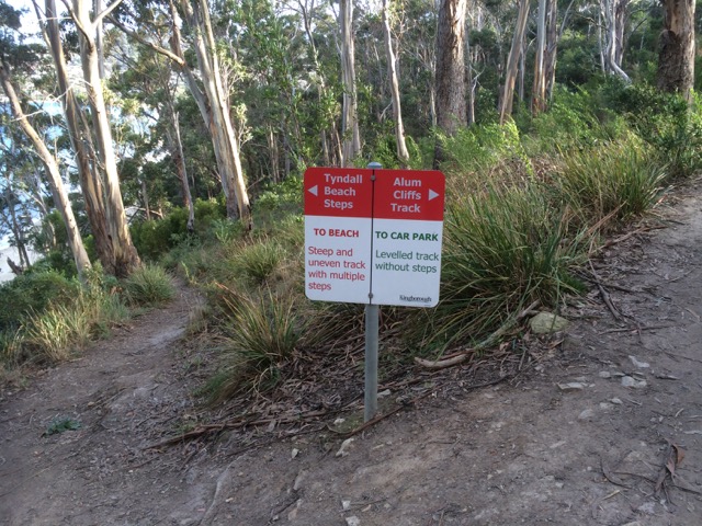
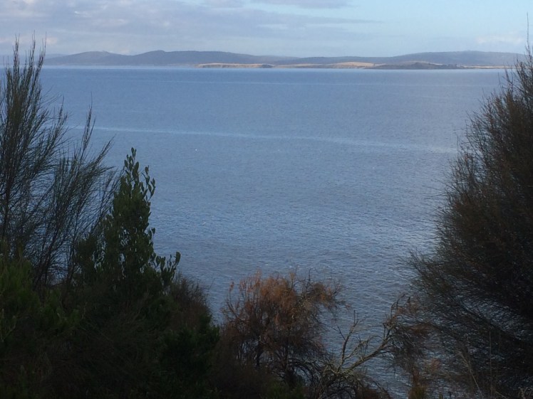
This day there was a lot of canine energy going on as we three urban explorers (two of us canine) headed off along the track, starting on Boronia Point behind the Kingston Sailing Club, where Boronia Hill descends down to the water.  They pulled me along, at first along the cliff top path under gums and casuarina trees. There are paths and wooden steps leading down to the track from gardens and hill top roads, and there is a small wooden bridge. On this day music drifted out an open window.  Someone was practising at their piano, and an elderly man sat on a bench where trees give way to a swathe of grass, absorbing the long views north over Kingston and Tyndall Beaches and across the river to the South Arm Peninsula.  The river gleamed with patches of white foam and still water. (It’s worth mentioning that rather sadly the bushland of the point is separated by a thick strip of houses and roads from the lovely top of Boronia Hill where there are tracks through remnant dry sclerophyll forest and delicious views from a grouping of large lichen dappled boulders beneath the trees.)

Soon we arrived at a fence, a gate and a sign saying reserve; no dogs, not cats, no camping – and there we turned back. I’d known this would be the case and I didn’t mind at all. This track was a real find. It made me feel expansive.  I  was happy to walk it any time.

THE SECOND EXPEDITION

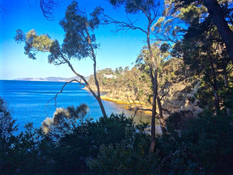
Snow was forecast and although the wild wind had calmed  it wasn’t until I reached Kingborough that the sky turned blue. Again the beauty. Again the piano music . I had a vague notion of what to expect beyond the gate because I’d explored the point using Google Earth the previous night, seeking a connecting path to Blackmans Bay further south but it was still a surprise to find that quite quickly after the gate the path started to descend. There are cyprus pines, the small cove of Boronia Beach opens up and the cliff line comes into view. Honestly, my first thought was Mama Mia! This could be a beach on a Greek island. Clearly a conventional thought – I’ve now seen is described this way many times. (But the sky has to be blue. I brought my sister here one overcast day not so long ago and it felt uncharacteristically sombre.)

From Boronia Point
The great view east:  South Arm Peninsula hiding Ralphs Bay from sight
Boronia looking south down the cliffs
Looking south with the Tinderbox Peninsula in the distance
The cliffs at Boronia Beach
Boronia’s cliffs.  Not short on character

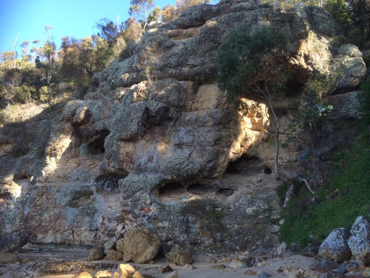
Some of the beach was in shadow but I had it all to myself (not a nudist in sight) as I wandered around absorbing its serenity. I discovered a manmade rock wall, quite low, just where there’s a rock platform, and I praised the cliffs for their beauty but mostly I was trying to find a way to walk to Blackmans Bay along the rocks.

There’s a small overhang below these cliffs (which are themselves full of incipient caves) and a crevice which stopped my progress.  No route south, it seems, but as I walked back through the clearing I saw I now had company. Two people were walking stealthily and silently across the slope, bending down periodically to peer at the ground with torches. On their advice, I took a path that led me through a small gate, past a tap and into someone’s garden. Dead end. I turned back and discovered they had gone. Next I tried the path that led directly up the hill. It emerged through another gate (a weakness for this reserve – two gates) and onto a long dirt road, rather beautiful.

IMG_3445
This sign reads no dogs, no cats, no camping… and people!  Shut the gate!
Jindabyne Rd entrance to Boronia Beach
Jindabyne Road above the beach.  Pony trap and picnic basket required.

I met a man collecting armloads of eucalyptus bark in a paddock on the other side of the road and somewhere around here the Boronia Country House Hotel once stood. Curzona Allport sketched it. You can see this print and a couple of postcards at the State Library of Tasmania. Back in the early 1900s people liked to take the ferry that docked at the Kingston Beach jetty and visit this hotel for refreshments, just like at Crayfish Point. A garden with rhododendrums and dreamy views.  But I was more conscious of the cyprus pines and the casurinas that had dropped curled tendrils all over the paths,  the wallabies that scattered as I made my way along the paths and evidence of middens, testifying to a pleasantly sheltered spot to light a fire and enjoy the river’s bounty before ships began coming up the river.

Easy access for scuba diving
Making like a swimming pool

Boronia Beach

Looking north to Hobart and across the river to the eastern shore.
Looking north up the Derwent River from Boronia Beach

It was only when I was heading home (through that first gate into this reserve – left open by the party of three I’d just past – that I remembered that the ornithologists had told me that Boronia Beach is the home of one of the last remaining rookeries of little penguins on the Derwent.  Even the sight of that suspicious couple with their tiny torches, walking where, ethically, they should not have been, peering down burrows, risking putting their troublemaking feet right through them – even this had not triggered memory. But what I did remember more clearly was a blog post written by Mike Litzow, an Alaskan cruiser who liked visiting this beach with his family while living in Hobart for a year. Someone had not shut the gate, he wrote  – and here I just have to say how sickened I am by how many gates to reserves along the Derwent I find left open. Who are these people??  

I’m letting Mike tell the story of blood and carnage.   His story testifies yet again to our great disconnect from nature. Here’s the link.  It starts with the death of one little penguin, ends with the death of more than 20 and the comments are worth reading too.

The rookeries around the Derwent are very small and very endangered.  At Boronia I’ve witnessed the gates left open, human feet trampling and, on my visit there earlier this month, people camping.

And all this is just  so not okay.


Derwent River: A Short Walk with Mr Brown

Taroona to Brown’s River

Looking north towardsHinsby Beach from the Alum Cliffs track

I had an assignation with Mr Brown’s River and so it seemed quite appropriate to invite him to accompany me, if only in mind, on the cliff top walk above the Alum Cliffs one day late last year.

IMG_3494

That day I’d paused at the beginning of the track, surveying the view from a picnic table above the cliffs while chatting to locals, but mainly, I was quizzing Mr Brown, a drop out medical student from the University of Edinburgh who was thinking about all things floral while his fellow students focussed on cadavers, and whose enquiring mind and botanical obsession had, with a little help from Joseph Banks, brought him here aboard the Investigator in 1801, on Matthew Flinders expedition to discover whether New Holland was  one island or many.

There was a breeze, I was ostensibly alone and a single yacht had the white capped river to itself as it headed up river just like the Investigator, which spent some time in the D’Entrecasteaux and the Derwent. Accordingly, Robert Brown spent a lot of time collecting plant specimens from Table Mount (aka kunanyi / Mount Wellington) and along the river, encountering and following the course of Brown’s River in the process. These are my tramping grounds, but on the voyage out he’d visited another of my favourite haunts – Cape Town, where he climbed Table Mountain several times and enjoyed botanising in the fynbos and across the surroundings slopes, including Devil’s Peak.

Defeated by the boulders below the cliffs (see previous blog) it was a whole lot easier rambling along a well formed path that often felt more bushland than clifftop as it wove through eucalypts (silver peppermint and blue gum) and banksias, past epacris in bold red flower, with the companionable little sounds of small birds calling. It’s a sunny and shadowed path with a faintly minty fragrance in places, that occasionally deposits one at the cliff edge for filtered views across to Trywork and Gorringes Points and the long vista through the gap into Ralphs Bay as well as north and south along the river’s two shores. The Iron Pot was visible out towards Storm Bay. I had no doubt that samples of the plants I was walking amongst were included in the 3000 specimens my companion collected and that made their way back to the UK on the very damp Investigator. A conversation between Robert Brown and Charles Darwin, I decided, would have been interesting. They were both lateral thinkers with acute observational skills of the natural world, including geology who spent time here that led to new insights.

Perhaps this is the rocky platform you can reach from Taroona?
Rock platform below the cliffs

These cliffs, where Bonnet Hill abruptly meets the estuary, are unstable and prone to collapsing into the river along their fractures and faults. They’re siliceous and weather from their greenish-grey to a far paler white, patterned with hues of oranges and lemons. Sometimes oxides and pyrites stain their fractures and as they’re composed of Fern Tree Permian siltstone they occasionally bear fossils. I sauntered over all this rich geology not much thinking about it except to wonder, as I walked by the junction of the Brickfields Track, whether the alum they hold ever found its way into the tanneries that used to line the Hobart Rivulet and made it whiffy back in the early years of settlement. Robert Brown came from Edinburgh, that cold city of stone and so it’s not surprising that geological samples, the substrate on which plants grow, and which moss, a favourite plant of his, is prone to nibble, were among his samples too.

Crossing bridges

I crossed three small rivulets by way of wooden bridges and passed a few other people out walking that day but otherwise had the friendly solitude of the forest all to myself until, quite unexpectedly, I was out of the forest and crossing a broad and sunny expanse of grassy reserve with lovely views from the bench down to the beach where people walked their dogs oblivious to the fact that they were being observed from up on high. I clambered down the steep steps to the beach. I had left Taroona behind and was now in Kingston, originally known as the Brown River Settlement.

On Tyndall's Beach

Brown’s River, or Promenalinah, as it was named by the Aborigines who enjoyed its bounty before their lives were rudely disrupted, divides Kingston Beach into two shifting halves and although it’s really a single beach the northern section that has gone to the dogs in the best possible way (although shorebirds would disagree), is known as Tyndall Beach. This section is  continuously shape shifting in the most beautiful way. There’s a small cove in the northernmost corner tucked behind a lovely rock formation, it is fringed by vegetation and eucalypts as opposed to the houses and shops along the main beach but we walk it with a heavy footstep and so there are few shorebirds.

Brown's River
Brown’s River (upstream)

Tyndalls Beach looking northTyndall Beach looking north

After  lingering at the cove, I chose the narrow path that winds through the strip of vegetation at the foot of the cliffs in deference to my companion. A fair number of his new discoveries from this area turned out to have been discovered already by La Billardière on D’Entrecasteaux’s 1792 expedition. The two men didn’t just have botany in common. Conversely, La Billardiere started off with botany but later qualified in medicine.

I crossed the casual parking area between park and beach. Time was against me but the northwesterly was due to swing south westerly so at least I’d have the wind at my back on the return walk. And so there I paused on the footbridge over Mr Brown’s River contemplating both it and the floodplain it has carved between Bonnet Hill and Boronia Point. The tannin in the river makes it whisky coloured. It rises on kunanyi and I’ve followed much of its course, from above Silver Falls, down to the estuary. It runs narrow and free down the slopes (although some of its water is detoured into Hobart’s water supply) and then it weaves through its floodplain.

Robert Brown found the river when Aborigines still camped here and enjoyed the river’s largess and the hunting to be had behind the beach. There’s still a remnant wetland and there’s still the remnant bush I’d walked through, but my eyes took in an urban landscape – houses smothering the floodplain, and houses on the surrounding hills with their gobsmacking views.  Looking down from the Channel Highway, the clubhouse of the golfcourse is the Red House built by John Lucas way back when.  He was a a member of the first settler family to acquire land here.  They picked up several hundred acres of land around Brown’s River and it’s on this land that, in about 1808, Kingston began to take shape.  (For a historical perspective see the photos below).  He found other things to, being the first person to describe a living cell nucleus and observing the tiny random movements of miniature particles down his microscope.  You learned about this in Biology.  It’s named after him – Brownian motion.

I retraced my steps, trailing my companion but mingling with modern day locals using the track. With the arrival of the south westerly the river grew wilder and the forest canopy transformed into an orchestra of wind instruments. I hoped the trees would hold.

I once took a walk  in Eastern Turkey with a friend. That path was the only link between two villages. It crossed a shallow river that my friend traversed on a donkey.  There were   caves where hermits had once meditated; the way we were walking was thousands of years old. The Alum Cliff track links Taroona and Kingston but it is purely recreational. It’s quite possible that Aboriginal feet originally made it but I don’t know this to be a fact. Even though these days the purpose of footpaths has diminished, in the same way that arriving at an anchorage by boat is so different in feeling from arriving by car, so is it different arriving at a well known destination by foot.

There are at least two suburban developments in Hobart that would have thrown Robert Brown into an apoplectic fit behind his desk in Joseph Banks’s library (he became its librarian). One is Tolmans Hill, completely natural not that long ago. The profound shock when the first house appeared up there! The dismay as the suburb grew. The other is the small enclave above Tyndall Beach that doesn’t really belong anywhere but has further eroded the landscape Robert Brown found so rich and strange. This used to be native bush but subdivisions continue to happen on Bonnet Hill and in the fullness of time the land still open land looks set to disappear.

Historic Photos of Brown’s River (Source: LINC Tasmania)

With Mount Wellington in the background

The Red House, cleared land and jetty

Bridge across the river

Brown’s River: looking across the river to Boronia Point

Entrance to Brown’s River (Mary Morton Allport)

Further Reading:
Leaman, David. 1999. Walk into history in Southern Tasmania. Lehman Geophysics, Hobart
Brown’s River History Group
Kingborough Council website
Australian Dictionary of Biography