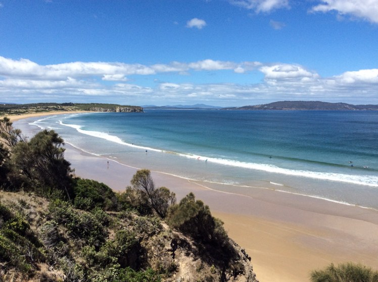
Clifton Beach and Pipe Clay Lagoon viewed from Cape Contrierity
Tiptoeing Along a Cliff Edge
Zooming in with Google Earth I thought I spied a couple of small beaches north of Smugglers Cove and the light tracing of a path through what looked to be a nature reserve. It was enough to convince us that it was worth trying to tackle the cape from Clifton Beach on the northern side and so on a sunny day at low tide, while people swam between the flags and surfers lolled on their boards beyond the break Cathy and I scrutinised the dunes and the cliffs at the southern end of the beach and found a path that led up a steep gully. With an eye out for snakes, we scrambled up it, trusting our weight to the branches of a couple of conveniently located bushes.
There was a narrow strip at the top between the ‘keep out’ barbed wire fencing and casurinas rimming the high cliffs, some of which had fallen away. Peering over the edge we could see their broken pieces tumbled down against the sea.
We found a path, but it looked wallaby made and we meandered on and off it making a difficult passage over and under vegetation, sometimes trusting to the generosity of land owners by slipping over the fenceline to where the walking was easier. In one memorable spot, we had pretty well a foot wide space of sky we needed to cross. I avoided looking down. The drop was horrible, but Cathy skipped over it oblivious to Death’s outstretched hands.
Our tardy progress was made even slower because the views were compelling and so we’d stop, point out landmarks we were confident about and speculate about those we weren’t.
Clifton Beach and Cape Deslacs. Tasman Peninsula is visible across Frederick Henry Bay
We finally found ourselves on the far end of the casurina copse, gazing down a long slope of golden grass and up the slope on the other side. There was no clear path and it had the look of large expanses of private land. With a couple of households dotting the cape, we decided to avoid rebuke and reluctantly turned back, walking single file. Cathy quietly observed the tail of a snake disappearing down a hole between us, so we were pretty pleased to reach the beach unbitten, and as the day was still young and the beach glorious, we decided to take an amble to the cliffs below Cape Deslacs.
The interplay of land and water made the walk worthwhile
Not much has been written about this cape, but on Placenames Tasmania I discovered that D’Entrecasteaux had noted this name on his voyages of discovery and that it had another as well – Watsons Bluff. Watson was definitely no lady because it’s my observation that places get named after men, rarely women. No doubt he was merely an earlier landowner whose name buried earlier ones tangled with mythology,
I dug about on Trove as well and discovered a 2000 fisheries arrangement between the Commonwealth and Tasmania that referred to a shark nursery in the ‘area known as Frederick Henry Bay and Norfolk Bay being all waters within an imaginary straight line between North-West Head and Cape Contrariety’ and in an article on geology in the Sanford area, Green (1961) mentions dolerite intrusions into mudstone as well as landslips in the cape’s basalt soil. As he also mentions lavas here, this little cape has some complexity but keeps a low profile in the island’s literature.
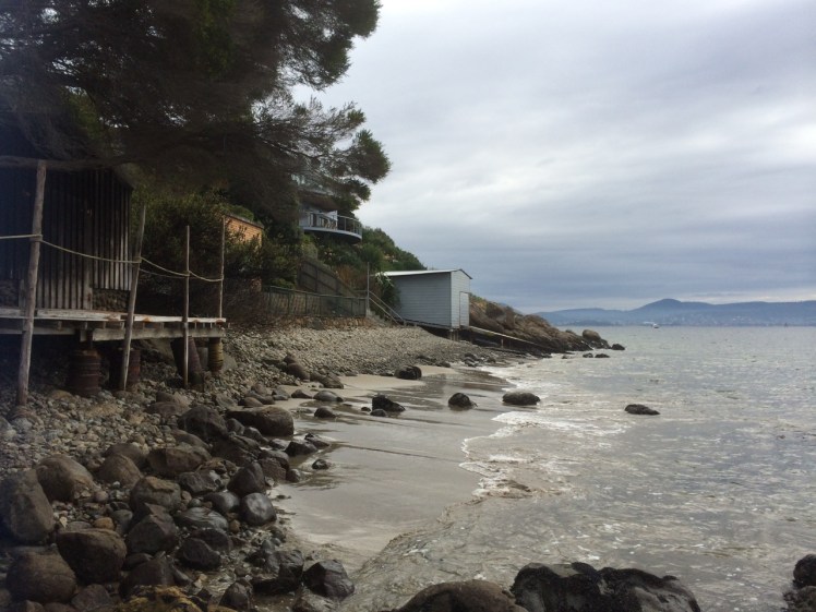
At the end of the beach I had to hop onto rocks and make my way between the river and a concrete wall. Around the corner a wooden boatshed looked as though it might end my walk but I found a way around it and although my walk felt seamless this is where I regard the Blinking Billy Beach 3 section as beginning. Just look at this picture. Who’d think there was a city here?
As you turn the corner at the point at the southern end of Blinking Billy Beach 2 (aka Half Moon Bay) you see this structure.
The same subjects preoccupied me as I walked along – the geology, the history, the structures – and, specifically, locating myself on this piece of shoreline. I kept changing my mind as to where I was in relation to the road above me but I wanted to do this walk without the help of Google Maps so that I had a real sense of (urban) adventuring into the unknown.
As you turn the corner at the point at the southern end of Blinking Billy Beach 2 (aka Half Moon Bay) you see this structure.
In wild weather this would be a windswept stretch of rocky coastline with views north to town, south into Storm Bay and across the river to more loveliness along the southern section of the eastern shore. On the day of my walk these lonely stretches felt pensive, secret and self-contained, and I felt myself more likely to encounter a nineteenth century smuggler along here than back at Red Chapel Beach or Blinking Billy Point. At the same time I felt as though the shoreline was as aware of me as I was of it.
I figured I was out of Geography Bay and this new perspective of the river renewed my feeling of exhilaration in the landscape and perplexity about ourselves – that we Westerners have been here since the beginning of the 1800s and yet, so close to the city centre, the nomenclature is still so sparse as to be mostly non-existent and so slippery where it is there at all. Many of us know more about London, Paris and places overseas than we do the intimate nooks and crannies of the river, the mountain and the great rifted catchment.
A few months after this walk I had a debate with a friend over just this issue. He’s a man that does real adventuring and exploring – the further off the beaten tracks of this world and out of communication the better. He is against nomenclature. He wants the earth’s places (mountains, rivers) left untainted by names but is prepared to compromise on a latitude/longitude co-ordinate.
I feel differently. As I walked along this stretch of coast wondering about the original aboriginal names for the places and features I was passing – names that over 30,000 years just have to have been rich, dense and redolent with mythology – it struck me like an epiphany, the extremely serious and overlooked disconnection we have with the earth. A shrieking Disconnection. A Disconnection so profound we’re trashing the planet beyond redemption and losing ourselves. No names – no recognition. No relationship. No honouring. No sense of gratitude. I looked at the magnificent, powerful river that I love so much, as much a goddess as the Ganges, and wished ‘sacred’ had not become a disparaged word because if anything felt sacred it was the animation I perceived in this river and its shoreline, so dynamic and timeless despite our culture turned beautiful parasite glued to its side. At the most profound level this existential disconnection is manifesting in more damaged psyches as each generation becomes less connected to the earth because how do you honour yourself if you can’t relate to and stand in awe of the greater entity you’re part of? As I wandered along the rocks, pausing to ponder their origins, diversity and beauty, I felt so utterly enthralled at the profligate beauty about me and a real grief that so many other compelling distractions have made it difficult for us to immerse ourselves in a landscape unfettered by human notions of time as was the case before our cultural evolution careered us away from hunting and gathering.
I had begun to pay more attention to my thoughts and less to the landscape when a sloping and strangely familiar boulder blocked my route.
Hello, Boulder.
About two feet of estuary rose and fell about its base. I didn’t want to take off my shoes and wade, the river’s temperature making it somewhat untouchable. On the other hand, my first strategy for climbing up the boulder’s side was hampered by the fact that a few weeks before I had dislocated and fractured my little finger while working on the boat with our mechanic, who I think of as being to engines what Leonard Cohen is to music.
I put my hands on the sloping rock. ‘I know you, Boulder.’ We had not met for a Very Long Time. Looking up I noticed a huge house with enormous windows. Now that was new to me.
When we were a whole lot younger we had come to look at a house – a beach shack really – at the bottom of Mitah Crescent. The owners walked us through their cacti and succulent garden down to a large boulder. The river lapped around its base but they assured us there was sand when the tide went out. We desired that boulder and that river access but knew that once we had paid for the property we would not be able to afford renovations for a while to come and so we sadly and stupidly decided not to make an offer.
I leaned my back against the boulder for a while, thinking that on this walk I’d barely noticed the Eastern Shore – I was so busy ‘paying attention’ (my current mantra) to the rocks about my feet and the all enveloping personality of the shore. My iPhone was losing power rapidly because of happy snapping and jubilant voice memos. I looked back along the way I’d come. I tested my finger’s capacity to help draw my weight up the side of the boulder. Not looking good.
Looking back at Blinking Billy Beach 3 from Mitah Crescent
My options were limited – I could fall, climbing that boulder. But if so, there was reason to hope that I’d be spotted sooner rather than later by the big windowed houses above me because at this point of the walk they had drawn closer and lower to the shore and so I took my chances, shifted my weight from disabled finger to used-to-being-bruised knee. Trying to be discrete, because I could not definitely recall whether the boulder was a right of way, I crept across it, slithered down over the boat shed’s jetty and found myself in an intimate and beautiful sandy cove. If the tide had been out when we’d viewed that house, we would both have lost our heads and hearts.
Looking back at Mitah Crescent cove
More rocks, more pebbles, the occasional rivulet and astonishing discoveries. I sometimes thought that paying too much attention to where I was about to place my feet I was missing out on rivulets, but in fact the way you find a Hobart rivulet is to use your nose. As they emerge dishevelled and emaciated from their concrete prisons they bring with them a distinct smell: stale old detergent. Yep. The cleaner we are, the dirtier we make the environment.
Then I encountered another boulder and, with an awkward gap, a double set of rails leading from boat sheds to the water. I slithered down to the base of the boulder and timed my scramble for a gap in the waves – and made it under the structure.
Double boat shed
I was about to leave Sandy Bay and enter the suburb of Taroona. but a little way around the next corner I found some more appealing structures and to my surprise, a sphinx like rock gazing out to sea. It’s waypoints like this that would undoubtedly have carried names earlier in the Holocene and I paused, feeling the loss of the language that once sung this landscape into being, the loss of a way of being in the landscape and interpreting the subtle nuances our less sophisticated gaze misses. I work with people who have dementia. In a more holistic way I think we have robbed the landscape of its earlier identity and a significant part of its memory.
As you turn the corner at the point at the southern end of Blinking Billy Beach 3 you see this structure. In the absence of official nomenclature, my personal name for it is The Mouheenener Sentinal
And it was along this stretch of shore that I nagging awareness came to the fore – one huge river, but only a handful of avian wanderers.
Where the hell were the birds?
Next blog entry: Photographs – Blinking Billy to the Sandy Bay border
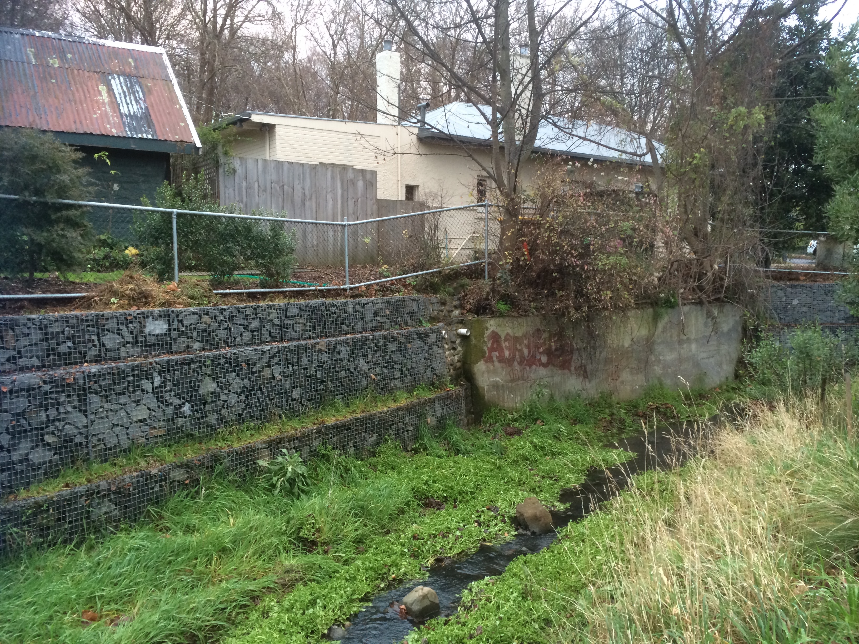
South Hobart, Dynnyrne, Sandy Bay – the suburban route began with a nondescript path outside the park gates that ran downhill to the rivulet, returning in a rush to its natural bed. I explored a bit, then crossed it to reach the forest track above it through to Romilly Road.
So here’s the sobering truth. The houses begin and the rivulet gets roughed up. A sign of worse to come, it travels between banks entangled with blackberries and forgot me nots, lawns and paddock. Some gardens make it their focus, others shun it. Regardless, it sounded almost cheerful flowing thin and narrow at this interface between forest and habitation. I had a good view of the state of affairs; this path follows a higher contour just below Stony Steps, another of Hobart’s secret places. There were cliffs; I reflected on how this rivulet, eons ago, before its landscaping capacity had been thwarted by us newbies, had carved an impressively deep valley.
I arrived at Romilly Street. After my wanderings the concrete seemed cold, shadowed and unforgiving. I, myself, mentally immersed in the rivulet, felt out of place as I paused to take some photos from the bridge. I could see no way of getting to the bottom. It was the domain of the ducks.
You barely catch a glimpse of the rivulet on the last stretch of Waterworks Road and what you see is hardly edifying. By the time it gets to Linton Avenue it looks scruffy and unkempt – and then it’s gone! it simply disappears beneath the road.
With a sense of anticipation, I took the little path I’d discovered at Linton Avenue on a previous sortie, full of anticipation that I would burst through into the park but my conjecture was wrong. It led me through to an enclave of flats. Back on Linton, I peered through a wild tangle of tall, dense brambles and weeds, a sign of neglect that indicated a rivulet could well be travelling underneath. There was nothing to see, nowhere to go and so at the Foodstore on King I turned into Overall Street, braving a soapy smelling periwinkle clad bank, down to the rivulet, where I stood over it taking photos of where it emerges from its tunnel and its route down through the park. Then I chose to walk the road rather than that sodden weed infested bank and encountered it at Parliament Street where it travels beside the oval. I was retracing my steps from a brief exploration of this area the previous week.
That morning frost had crunched under my shoes as I walked upstream along the rivulet flowing between gardens and park. I’d tiptoed past a tiny tent in a hidden glade (someone sleeping rough) and had expected to emerge on Linton Avenue but had arrived, instead, on the freeway, quickly ducking back down lest I be noticed by the morning traffic.
Again I crossed the road. There was the place where I’d stopped to chat with a man who directed my attention to a house, once a mill, on the banks of the rivulet, and there again, down a steep descent, was the end of Fitzroy Place and the woebegone rivulet now in a stormwater drain heading beneath Regent Street. I sauntered down Queen Street and detoured into Lincoln Street to meet it again where the story was one of ducks and daks – ducks fossicking on the bank and old underpants caught on a rock.
I walked down Jersey Street and found the rivulet carrying a plastic bag. I was there to greet it at Dr Syntax, where it had accumulated plastic cartons and I was there as it entered another stormwater drain (yep, we really esteem this rivulet) and was there to witness it running down its gutter behind the back gardens on Osborne Road. Sombered, I headed down Quayle Street.
Down near the beach the rivulet gets some recognition but litter marrs the scene – spray cans, McDonalds takeaway products, trapped by a buffer – Mary Ann Bay Beach is grateful. What a terribly filthy, crass minded species we are, I was thinking, and then a welcoming tide came rolling in, and the rivulet, once fragrant, now toxic, depleted itself into the Derwent. My dogs rushed to greet me and the geologist waited. Short Beach was lit with slow afternoon activity and the light was mellow. Feeling like a traveller arriving in another land, I was both buoyed by the loveliness of the walk to Romilly, the activity on the Esplanade and sobered by how quickly the rivulet had been ravaged.
We found a bench, we spread a cloth, we poured puerh tea, and sitting side by side eating chocolate and imbibing this smooth antique tea, I told the geologist of the places I’d been and the things that I’d seen.
Meeting forget-me-nots, top of Waterworks Rd
Sandy Bay Rivulet running past Pillinger RoadSandy Bay Rivulet from Dr SyntaxSandy Bay Rivulet mouth, Short Beach Sandy BayTea time after the rivulet walk
Part 3: Hall’s Saddle to Waterworks: A rivulet’s point of view
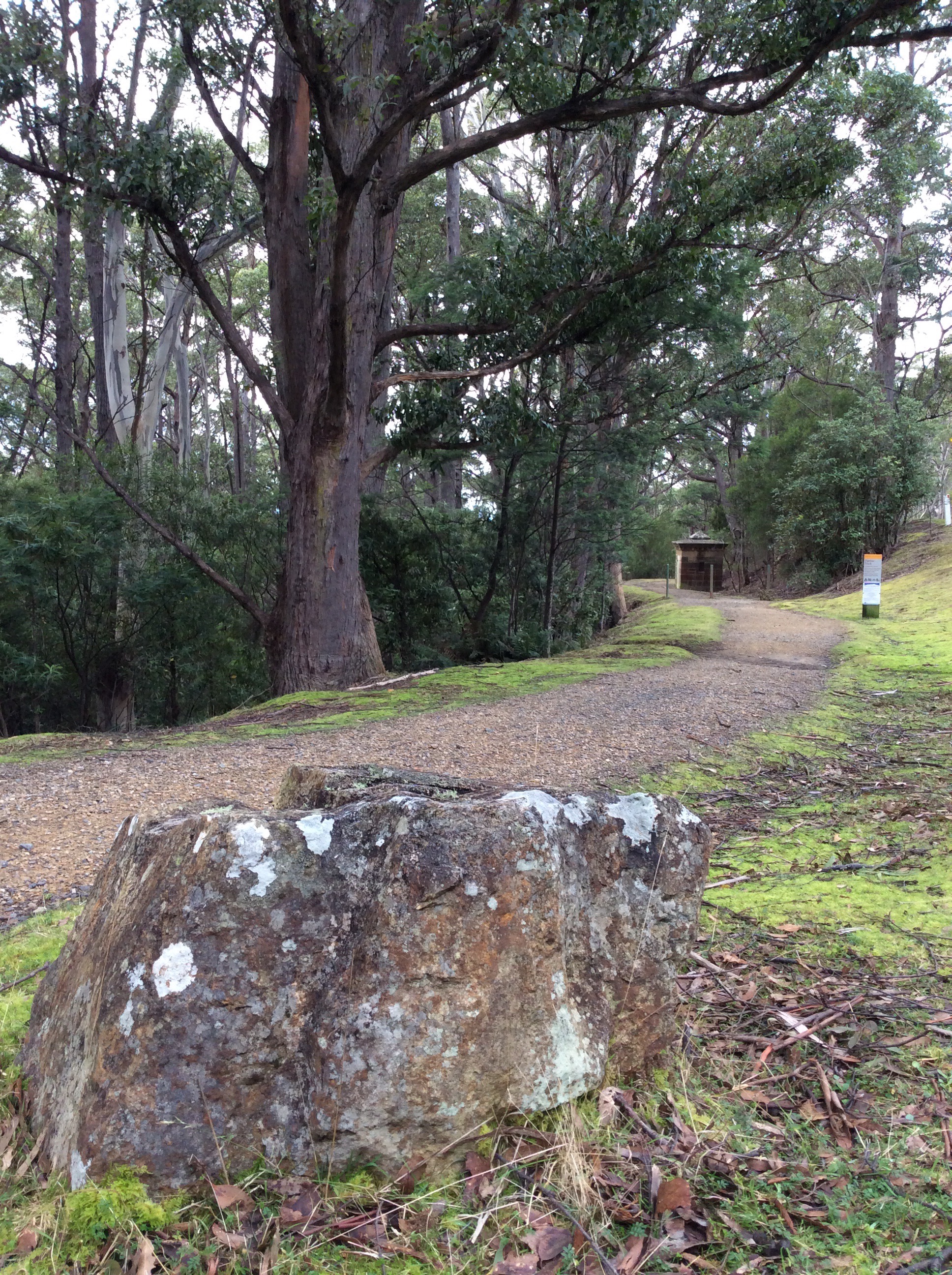
The third stage begins: Hall’s Saddle
I was strolling a high contour, the tiny cluster of houses at Finger Post on the far side of the valley. Far below, the rivulet flowed beneath the forest canopy in the Turnip Fields valley and as I walked I tried to hold its presence in my mind. Turnip Fields
The houses on Huon Road hove into sight and the Derwent River in the distance. Gracious eucalypts beside the path had bark I had to stop and admire, she-oaks, orange banksia in blossom, and closer to my feet the tiny red flare of epacris impressa. I was relishing my solitude, enjoying the rhythm of my stride but making slow progress – there were a lot of little water courses I kept stopping to examine. Alone with my thoughts I faced the same question with the rivulet that I’d had when walking above Mitchells Beach on the South Arm Peninsula: how close must you physically be to something to be actually walking it? And in what way can you be said to be walking something when you don’t know it’s there? (I was thinking particularly of rivulets in the city and how, walking down a road we are most of us unaware that a rivulet might be flowing beneath us, imprisoned in a drain.)
Near McDermotts Saddle
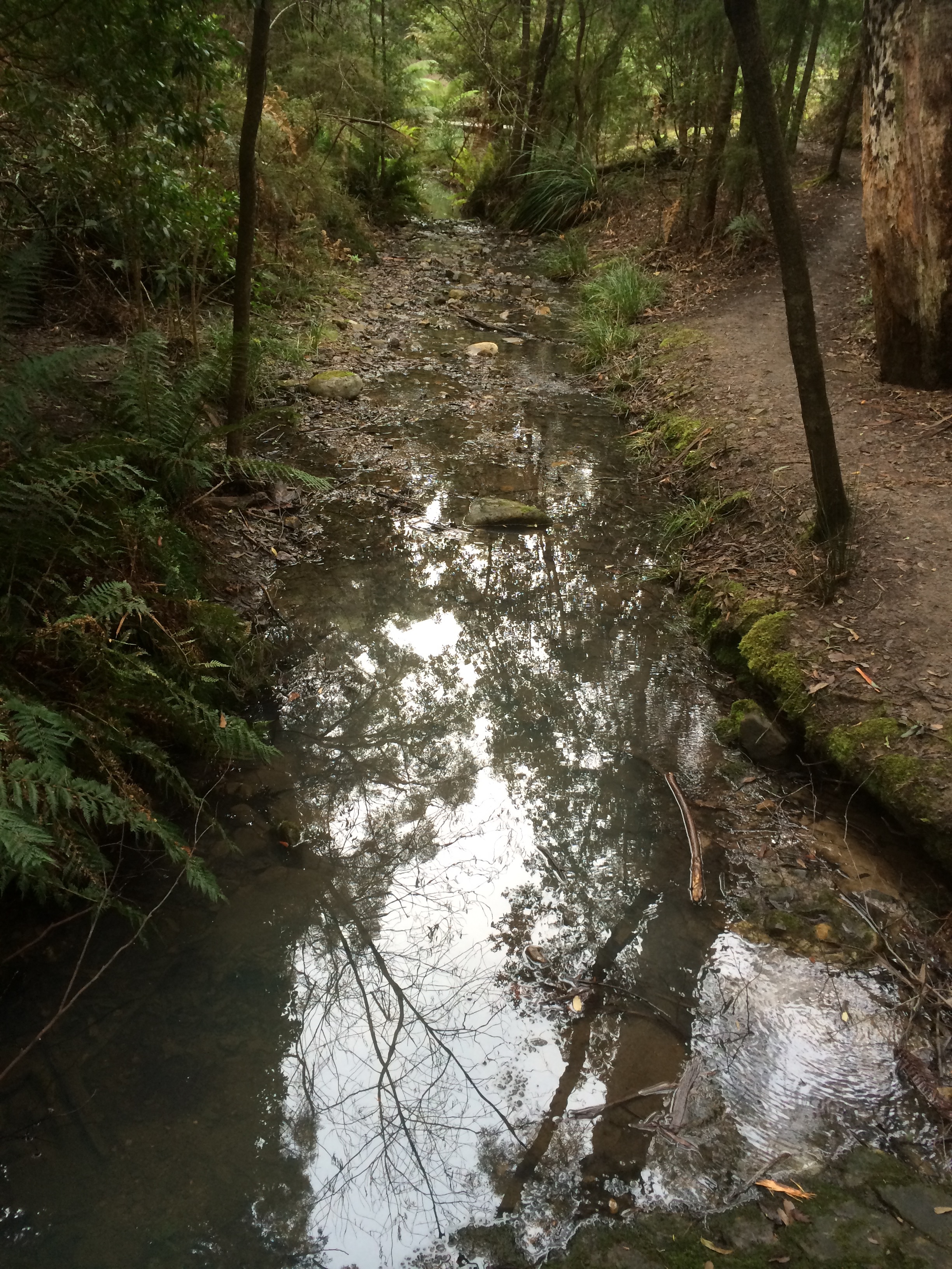
I reached the abandoned paddocks of McDermotts Saddle, the lumpy land that bears old traces of a building. Superb blue wrens flitted ahead of me and a raven called lazily. A little while later I got a view of dark water down at Waterworks. I came to the steps and descended, then lingered. Gentle Annie Falls and a series of cliffs demanded exploration – their’s is a long quiet dreaming up here in the eucalypt forest. Contemplation over, I followed the Circuit track, paused again at a poignant memorial seat to young life cut short, then finally arrived down at the rivulet at last, just where it emerged from the forest running small and shallow, slightly cloudy, over its dark forest bed, a stride wide, meandering around boulders. I walked beside it companionably, stopping to capture its voice at a cliff and again where it runs over pebbles.
The rivulet enters Waterworks
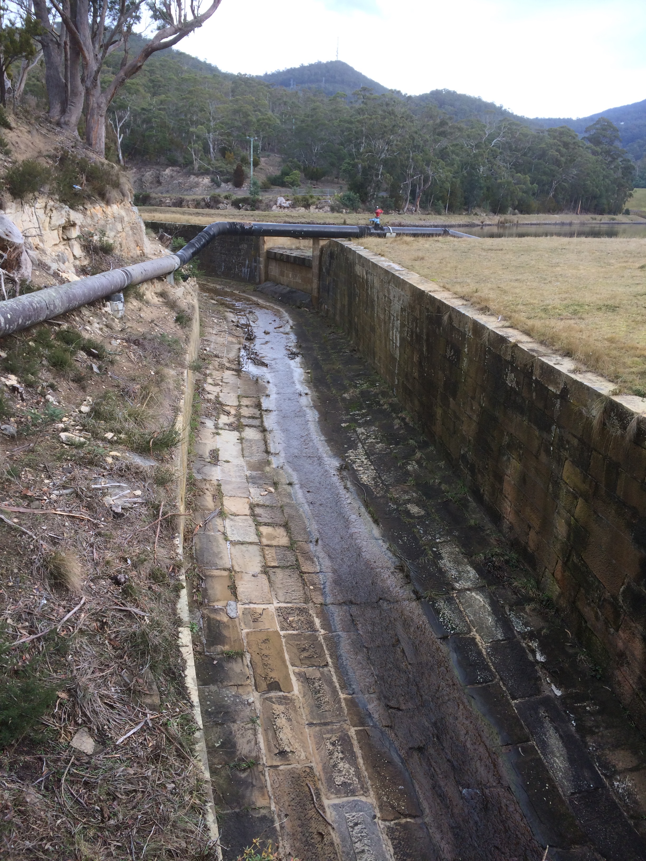
Shortly after this I had a choice of path but the rivulet had none. The rivulet is tricked as soon as it enters Waterworks, apparently for the misdemeanour of flooding (or landscape building, depending on your perspective) in earlier days. It is sneakily led into a moat that runs around the reservoir to the right while the usurper, the reservoir, inhabits the bed the rivulet made like a gigantic cuckoo’s egg.
Cuckoo’s egg: The Reservoir
I could have walked beside it, commiserating, but having been that way so many times before (the bitumen, the picnic tables), I went left and walked a forest trail. As usual the gulls were hanging out on the water and when I crossed over between the upper and lower reservoirs there was a raven grubbing for food, some tassie hens, ducks and plovers. Munching on an apple, I rejoined the disheartened rivulet as it moved unwillingly down its moat, squeezing itself into the very centre as though it didn’t really belong there. I passed a bbq in action and a couple arm in arm enjoying the view. Two ducks, flying low, winged pass me on their way up to the top reservoir and as I approached the gate I spotted the first exotic plants: an escaped agapanthus. It was a harbinger of things to come.
Displaced rivulet: the ecosystem blanks out. No life to foster, no landscape to build