Frederick Henry Bay: Seven Mile and Five Mile Beaches

Most of the sand on the world’s beaches consists of two minerals, feldspar and quartz.   They are particularly stable and that makes them especially durable.  Take a peek at sand through a microscope and you’ll see that the grains look like tiny pebbles bigger than silt, smaller than gravel, many hued, transparent quartz, weathered smooth, pulverised and polished over the millenia.  They form the unique, mobile fingerprint of the beach, created by the swish and swash of waves, tides and seafloor shape, gradient and cover.  They may wash more or less straight up on to the beach or away from it, or be carried there by longshore drift, arriving at an angle, a part of the shifting sediment carried along by the coast-shaping sea.  

***

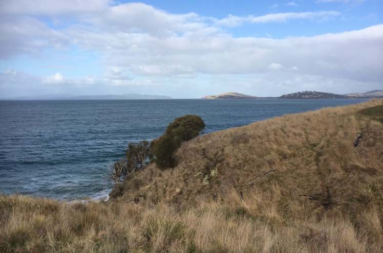
Seven Mile Beach (T397) 

Seven-Mile-Beach-and-Acton-Creek-1.jpg
Acton Creek meets Seven Mile Beach

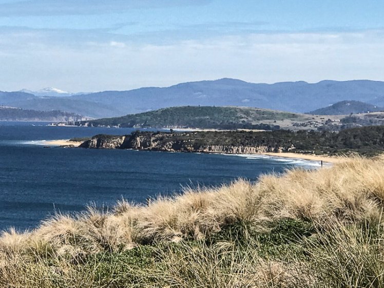
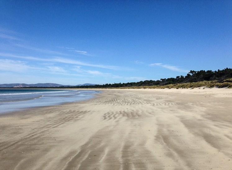
Seven Mile Beach, mostly southeast facing, is 15 km from Hobart and is pretty much the closest surf beach to the city.  The waves aren’t usually much more than a metre here, but they’ve travelled across about 20 km of Frederick Henry Bay to break on this seven mile long beach backed by homes at the western end and a beach reserve further east.  There’s a road behind the dunes and the reserve.  It’s dirt up the eastern end, bitumen down west.

One of the most obvious features of this beach is the unhappy pine plantation that extends behind it and encroaches on the dunes but if you’re standing on the beach it’s the great sweep of sand and the views across Frederick Henry Bay that are the most compelling.

What’s not so obvious when you’re on the beach itself is that it is a massive ‘sand spit that traverses the axis of the eroded Coal River Valley rift’ (Leaman, 1999), where once back in time there were twenty active volcanoes.  In this valley early settlers found skinny seams of coal, enough to inspire hope that quickly collapsed into disappointment.

We’ve come to this beach when the tide has been so high it’s been right up to the marram infested, undercut dunes and there’s been insufficent beach for a walk.  We’ve come on extreme lows when the beach’s width and a sunny sky has made it particularly inviting and horses, dogs, swimmers and beach umbrellas have given it a festive air. You don’t want for space here.  This beach allows everyone to disperse along its generous length.  Some people seem to make use of the dunes to disperse with clothing altogether, but in Tasmania the sun has a sharp edge and can end up being a painful experience for delicate extremeties.

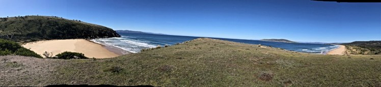
This is a go to beach for cycling at low tide when the sand is hard and you can fly along its length all the way out to Sandy Point where Pitt Water, a 3,500 ha barrier estuary spills into the bay and Seven Mile Beach and Five Mile Beach meet.  This beach system they’re both a part of has actually built out 1 to 2 km seaward, according to Short (2006), ‘as a series of more than 50 low foredune ridges which have subsequently been transgressed by dune activity that increases to the east.’  It’s on this barrier land feature that the pines were planted and Hobart’s airport built, so a particular Seven Mile Beach experience is planes landing and taking off low overhead.  Pitt Water-Orielton Lagoon is one of Tasmania’s ten Ramsar wetlands and provides refuge for threatened species, both avian and botanical.

Sandy Point and Five and Seven Mile Beaches
Looking across Pitt Water to Sandy Point where Seven Mile and Five Mile Beaches meet.  Photo taken on  Tiger Head Beach, Dodges Ferry

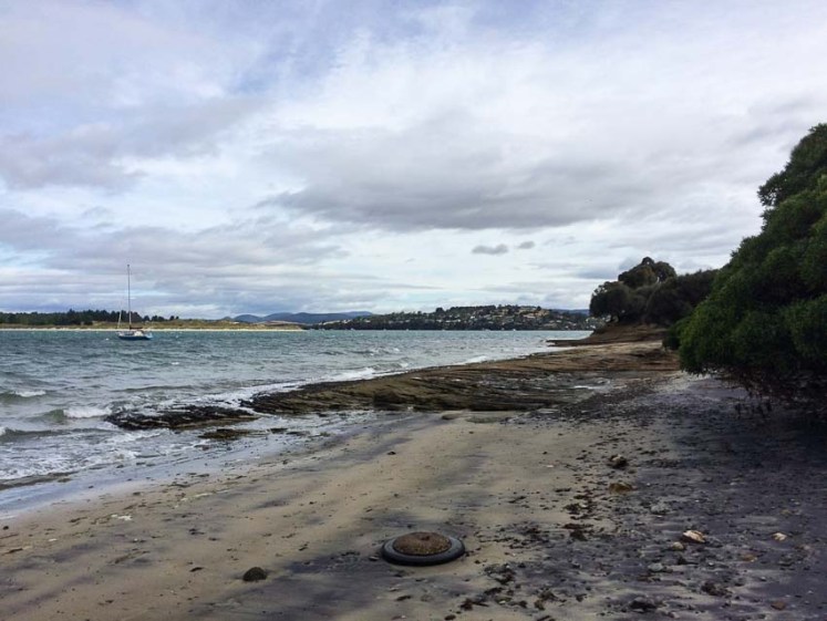
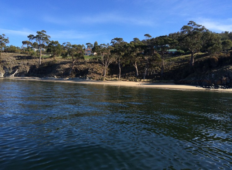
From Sandy Point you can see Lewisham on Pitt Water’s eastern shore, a skinny community of houses that traces the shoreline of this estuarine lagoon with the community of Dodges Ferry at the mouth. Looking west to the far end of Seven Mile Beach where the walk around Single Hill ended is actually the best known part of the beach.  The hill, the houses and Acton Creek give it an intimacy the rest of the beach lacks.  The thin western finger of the small township broadens out eastwards and the houses start extending inland across that ancient but shallow barrier dune system.

Seven Mile beach from the Sandy Point or eastern end
Ripple marks on Seven Mile Beach.  The darker lines are caused by heavier minerals or organic matter trapped in the shallow troughs

Five Mile Beach

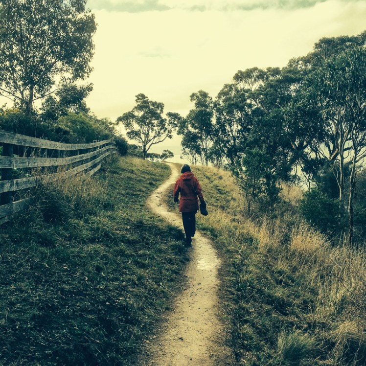
This is no beach for a bike.  As a Ramsar site it’s the domain of shorebirds.   I came here with the geo on a spring low tide that hadn’t receded as much as we’d have liked. There’s a track behind the beach that meanders through pine forest, then turns to follow the Pitt Water coast.  True forests uplift and Tasmania has magnificent ones that provide this kind of experience, but plantations cast a desolate atmosphere both sad and disturbing.

In his book The hidden lives of trees: what they feel, how they communicate – discoveries from a secret world, forester Peter Wohlleben  discusses the various ways trees suffer in plantations. Communicating via electrical impulses and chemical messages with various fungi as support networks the lives of trees is worth getting to know about.  A monoculture isn’t healthy and doesn’t make for happy, healthy trees.

Five Mile Beach on Pittwater Lagoon, looking towards Sandy Point

We didn’t complete this walk.  I hadn’t read this book yet, but the atmosphere was so unedifying that it stilled conversation and dampened our mood.  At a certain point we stopped and reluctantly agreed that we found the damaged dunes and miserable trees (upended in places, and ravaged by the sirex wasp)  too disheartening, particularly when we imagined what the dune system was like before human interference.

We found a way on to the beach via a pathway through the eroded dunes and because the tide had receded further out by then we could walk along the shallows enjoying the occasional presence of a few shorebirds.  Crabs beginning to emerge from their burrows and apart from the sad sight of  trees that had fallen with the collapsing dunes the view of Pitt Water was a whole lot better.

A combined Seven Mile and Five Mile Walk: CCC brochure

Tip:  If you’re planning on walking Five Mile Beach, wait for a spring low tide.

Frederick Henry Bay: Lauderdale’s May’s Point to Seven Mile Beach along Roches Beach and Single Hill

Roches With Gritted Teeth

We couldn’t have chosen a worst day for our walk.  It was snowing on the mountain, raining in town and the best the temperature could manage was a measely 7 degrees centigrade.

Cathy reminded me that we had stoic Scottish blood coursing our veins; I kept secret my preference for a sauna.  Our hardiness extended only so far and we agreed to leave one car at Seven Mile Beach.  That done we sought out a Lauderdale cafe to psych ourselves up for the miserable walk ahead.

Our cafe on the western side of the suburb had a view across Ralphs Bay on the Derwent River  to the city and the mountain and from the table we’d chosen beside the wood heater we looked out at water chaotic with white caps.  Kunanyi, normally dominating the western horizon, had vanished,  the wind was loud and I was pretty damned glad I wasn’t sailing.

‘We had hardy ancestors,’ said Cathy firmly.

‘There might not be much beach to walk on,’ I suggested in a faint voice.  It looked to me like the conditions had whipped up a higher than usual tide.

Lauderdale is a largely low lying suburb that takes in the isthmus where the South Arm Peninsula begins and straddles Frederick Henry Bay in the east and the Derwent River in the west. Back in the early 1900s there had been enthusiasm for a canal that would reduce the distance to Hobart for the shipping of farm produce, much like the Dunally canal further north saves yachts the trip around the Tasman Peninsula today.  But work was hampered by the First World War  and when they got down to business in 1924 storms made it apparent breakwaters would be needed on Roches Beach to prevent silting.  Too expensive, the decision makers concluded and the project was abandoned, leaving a 1 km canal that doesn’t quite reach the beach and is hardly visible at the Ralphs Bay end (Alexander). Later I discovered that the layer of sand in this area is skimpy.  It covers over two hundred metres of clay, sandy clay and boulder beds that filled in the ‘eroded, ancient rift valley landscape as sea level rose.’ (Leaman, 1999).

The two most significant bumps in its landscape are Richardson’s Hill with May’s Point below it at the southern end of Roches Beach and Single Hill to its north.  Our walk was to begin below the first and take us around the second – but the weather was so truly terrible that we prevaricated by driving slowly up Richardsons Hill and then slowly back down to Roches Beach, slowly parking the car close to May’s Point and slowly donning extra thermals and wet weather gear before braving the lashing rain.

We began walking down the beach in a most unhardy manner.  The tide was indeed high, the work of the stormy south westerly, but at least the wind was at our backs. Slowly our Scottish blood began exerting itself and snug in all our layers we got our stride up and congratulated ourselves for defying the weather.

Lauderdale takes its name from Ann and Robert Mather’s Ralphs Bay farm, Lauderdale Park.  They were early settlers and their inspiration was Lauder, Robert’s birthplace near Berwick-upon-Tweed in Scotland. When it comes to hardiness Ann totally put us to shame, ‘raising her children and managing an unwilling convict workforce’ on this isolated farm (Clarence City Council).  By the 1950s settler hardiness had given way to hedonism and holiday shacks began filling in the landscape.  These days it’s suburban homes fronting up to the dunes along this 3.5 km section of the beach, their gardens spilling out into the public reserve.

Shells on Roches
Beach assemblage both human and natural

The narrow beach sloped steeply that day and the waves were slapping at the dunes in some places, undercutting them and threatening to saturate our ankles, so we decided to see if we could find a track behind the beach and for a while picked our way through undergrowth and escapee plants. This high sea also had us discussing Lauderdale’s vulnerability to storm surges and sea level rise, much like its southern neighbour, Cremorne.  The isthmus isn’t much above sea level and the small dunes along Roches are already compromised by human impacts.  We also spent considerable time discussing whether we were walking one beach or several and what, if anything they were called. Later I referred to the guru, Andrew Short, who in his inventory referred to Roches Beach as a 5 km stretch of increasingly wider beaches lying between Mays Point and Single Hill, although actually 3 and 4 narrow again, we found. For the record, he called them Roches Beach and then Roches Beach North 1, 2, 3 and 4 but the locals probably have different names for them.

IMG_4500.jpg
The beach makes another curve at Bambra Reef and begins to broaden

We passed Bambra Point and its reef as the weather began clearing and reached the part of the beach that Cathy most loves because it holds memories of regular visits with her children when they were little.  She pointed out the shelter provided by the trees and Epping Park Reserve behind the dunes and took me up there to take a peek at Lauderdale Yacht Club, the base for catamaran sailing in Hobart.  Later, reading David Leaman’s Walk into History (1999) I learned that there are some brilliant examples of Permian rocks in this area.  Also, right at this point on a low tide you can see the irregular roof of the main Jurassic dolerite intrusion.  (If you want to know why the dolerite in this area is great for giving you an idea of the gigantic intrusions dominating central and eastern Tasmania  pick up a copy of this book and take a stroll here – it’s definitely worth it.)

IMG_4655
Not just any old rock.

Single Hill and North Roches Beach (T 398)

We passed the sailing club and the boat ramp and took the path leading up Single Hill, that singular landmark as you fly into Hobart. Initially we walked below big houses I hadn’t known existed and at the base of the hill Roaches Beach (N3) aka Short’s T399, a narrow 50m ribbon of sand and rock, that is a continuation of Roches Beach N2 aka T400 was being bashed by waves.

View from Single Hill.jpg
On Single Hill with Richardson’s Hill, Cremorne and Cape Deslacs in the distance and the Tasman Peninsula in the distance

We were walking amongst eucalypts and she-oaks following  what is really pretty much a contour path with a lovely sandstone bridge.

IMG_4510.jpg
Walking Single Hill

Cathy pointed out the most northern beach below us (T398). There were steep steps leading down to it but we continued on around the hill, stopping every now and then to take in the sweeping views of Frederick Henry Bay and the Tasman Peninsula.   But if you’re keen on geology this little beach is definitely worth a visit because according to Leaman the Permian rich siltstone here is rich in fossils.  Far away over the bay we saw enormous waves breaking on a point we struggled to identify. Eventually the path turned towards Seven Mile Beach and we gradually descended on to the sand.

T 397 Seven Mile Beach (southern corner)

There are shacks clustered in the corner beneath the hill south of where picturesque Acton River enters the beach.  A small flock of ducks were enjoying it as we crossed the wooden bridge.

The walk had taken roughly 3 hours but I was enthralled by it and so the next Saturday I was back with my friend Rosemary White, who had sore knees and wanted an easy walk.  This time, with an impeccable blue sky and far kinder weather we walked it the other way around, from Seven Mile to Launderdale.

Again, the beautiful creek at Seven Mile, and again the expectant flock of ducks.  Walking this way there were points where it seemed we were trailing the edge of a great bay with a relatively small opening.  Identifying landmarks was difficult but our geographic guesses were confirmed by a local we encountered, walking alone with his radio tuned in to the racing.

Reaching Roches we turned and walked Roches N3, pausing to examine the small butterfly shaped shells that had washed up everywhere on the sand.

Kayaking Single Hill

Still not done with this area  I brought others to walk it and keen to explore Roches N4 I paddled around Single Hill from Seven Mile Beach to Lauderdale.  It’s a short paddle but (small confession) when the wind came up my enthusiasm for paddling to May’s evaporated and I pulled in early.

Kayaking Single Hill.jpg
Calm moments off Single Hill and Roches Beach N4


Frederick Henry Bay: Goat Bluff to Cape Contrariety – Calverts Beach

CALVERTS BEACH (T411)

The moon had given us a low tide and with a slender window between cold fronts Cathy and I whipped on our walking gear to continue our saunter along the coastline.

We paused on Goats Bluff to look across the long expanse of Hope Beach before making our way down the narrow path through native bush to the beach. The last time I’d come here it had been 25 degrees and people, heavily tattooed, were lounging under umbrellas beside the sedimentary cliffs.  Today was crisp but sunny. Ever since the geo and I had driven off the ferry after a couple of weeks spent in shorts and t shirts on the mainland, Tassie had been lashed by a bout of wild, wintery weather, so this was a brilliant reprieve.

FEATURE BENEATH GOAT BLUFF.jpg
This feature in the cliffs below Goat Bluff may be linked to its history (see previous blog post)

Calverts had been our ‘go to beach’ when we first came to Tasmania.  Every time I walk it I remember a tiny kelpie x border collie puppy from the Stirling Ranges in Western Australia. Along with two of his siblings he’d been bundled into a box and on to a plane in Perth. Several hours later I plucked him out of that box at Kununurra Airport in the Kimberly region of WA and for the next two years he enjoyed field camp living with us. The creek, the waterholes, the fishing expeditions and the parties in the annex, the walks down to the chopper to meet the guys returning from another blisteringly hot day doing mag anomalies. Two years in a caravan in boab country, living small. Two years in a tiny field camp in all that wild, vast inaccessible space. We were lucky though, because sometimes, in the chopper, we got to explore caves rich with rock art and canyons with verdant microenvironments that felt way off the map, far from roads or even a track, that you wouldn’t know were there unless you could spot them from the air.

This puppy, born of working stock, climbed trees (sort of). His acrobatics intrigued children. His speed was astonishing and Calverts was a beach he raced along, trying unsuccessfully to round up seagulls. He drove around Australia, squeezed on top of a mattress that was wedged on top of a motorbike, that weighed down the already sagging boot of our Holden station wagon.

Cathy and I walking along discussing economic conundrums, saw a spout of water off Betsey Island, just as two birds lifted into the air close by.  Further down the beach a lone man stood on the sand dunes assessing the swell on this rip-prone beach. Behind him, the dunes sloped down to Calverts Lagoon, a change in the vegetation and a quieter sort of environment.

We reached the opposite headland. This is where the geo and I have always turned back, but had occasionally noticed people making their way down it and had puzzled over where they were coming from. Cathy was the person who let me in on that secret, but before we set off up that path we explored the rock platform that slants upwards around its base because another beachwalking friend had told me that if you climbed to the end of it and peered around the corner you could see a little cobbled beach. But what we saw when we reached the end was the narrow shape of a gulch that at low tide probably did leave cobbles and rocks exposed. While I stood there musing, Cathy bounded up the daunting cliff face and when I looked up I could see her standing on the headland enjoying the view.

I followed slowly up that steep side. There was only marram grass to grab hold and it looked rather puny. Besides, it’s hostile and I wasn’t wearing gloves. I surveyed the big drop beneath me and the hard faced rocks. Those I was clambering up were damp and my shoes lacked grip. One up to Cathy, I decided, and slithered slowly down to a more welcoming ledge before seeking out the little path further back along the headland.

From the top we could see Calverts Lagoon, fingers of land and stretches of sea. The best was yet to come, because on the other side of the bluff lies a hidden beach, outstandingly beautiful. I’d been here once before, pretty much as soon as Cathy had told me about it. It had been a hot day and our party had disturbed a lover’s tryst. ‘Beware the snake,’ the man had yelled at us, jumping up to shoo us away. We had clearly destroyed their moment because it wasn’t too long before they were trailing us back along Calverts.


Smugglers Cove and Calverts Beach agn-1
Smugglers Cove and Calverts Beach


Smugglers Cove (Beach T 410)

We descended through soft sand, stepping over dead birds and a dead sheep to reach Smugglers Cove. It’s seriously lovely and is cupped by the steep headlands of Cape Contrariety. It’s also seriously private and intimate even though it’s spacious enough to accommodate several parties of beach goers. Two eagles wheeled above us and a pied oyster catcher stood on the rocks regarding us.

After a while we followed a fence line up the bluff on the other side, keen to reach the other end of the Cape. I’d tried hunting down the owner of the private land without any luck, so we didn’t like our chances. There were mutton bird burrows. There were sheep, happily alive. We followed their tracks until we reached a fence that crossed our path.

This was as far as we figured we could go. From there we could see the spot we’d reached on an earlier expedition, when we’d attempted to cross the Cape from the Clifton side (see next blog post), so that long slope separating us from that point near the top was frustrating. We knew there was a nature reserve along the tip of the cape and that another beach (T409) was down there too.

On the Beachsafe site its described as ‘a 150 m long high tide cobble beach located along the western end of the cove, with a sand and rock low tide terrace. Waves averaging about 1 m break across the 50 m wide bar and surge up the cobbles, with the steep slopes right behind. The 4 ha tip of the cape is a private wildlife sanctuary.’

Cape Contrarity Calverts side.jpg
Walking Cape Contrierty

We’d been defeated but the walk back was uplifting. A yacht was crossing Norfolk Bay, a north easterly filling its sails. That whale breached and blew again. We saw Little Betsey Island tucked away behind Betsey Island, Black Jack Reef and the great sweep of Hope Beach beyond Goats Bluff.  We saw the Iron Pot at the entrance to the Derwent and snow on kunanyi and the Snowy Range.   And as we clambered back down the path to Calverts there were seven surfers in the swell beneath us, where originally there had been only one. You’ve got to have ichor coursing through your veins to take  on Tasmania’s winter ocean. I lack even a single drop and just the sight of them had me zipping up my down jacket.

Cape Contrarity Calverts side - snow.jpg
Calverts and Hope, with snow in the background


This walk: 1 September 2017. If you’ve walked this cape or know the contact details of the farmer, please let me know so we can try again.