Frederick Henry Bay: Lewisham and Okines Beaches

Walking with Matisse

Sundra and I had decided to walk from Lewisham to Dunally and for these walks her best friend, Matisse, invariably came too.  Despite his venerable age he always kept up with us and chose to stick with whoever might be lagging, although sometimes he’d set off alone to find a different way around an obstacle.  And ever polite, he accepted us picking him up and passing him over hazards he couldn’t manage alone.  He’d pick up his dignity and continue lightly finding his way.

Rest in peace, gentle Matisse.

Dodges Ferry and Lewisham:  Sharing a Magnificent Landscape

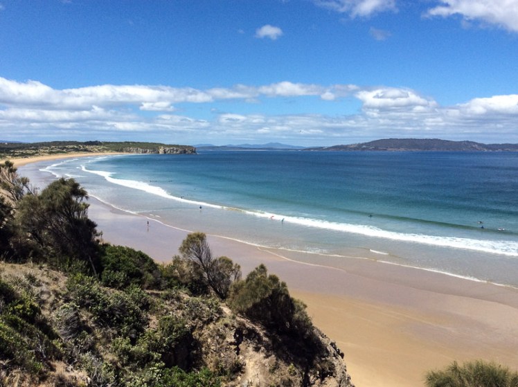
Long ago I met a writer who lived at Dodges Ferry. It was considered an odd choice by my friends, all better acquainted with Hobart than I was at that time, but walking this area I realised the writer was prescient. Its proximity to  vast Pitt Water Lagoon, quiet coves, a string of sheltered beaches, a magnificent headland, beautiful surf beaches and a photogenic river give it an enviable natural richness.

Lewisham consists of a thin string of houses that extend along the eastern shore of the inner entrance to Pitt Water Lagoon just north of Dodges Ferry and so it isn’t physically on Frederick Henry Bay although its watery landscape is intimately connected to the bay.  It strikes me as an under rated place, perched as it is above the water with access  to some lovely beaches via a rambling path.

Dodges Ferry and Lewisham probably don’t want their natural wealth proclaimed to the world less the financially obese rush in and take over.  For the moment laid back Dodges in particular still has enough shacks and rutted roads to keep it feeling like an authentic holiday village.

It’s about a 35 minute drive from Hobart to Lewisham and Dodges Ferry and it’s rich with water views  if you choose to take the Lewisham Scenic Drive turn off.  It’s my firm belief that one should always take the scenic route and  for this series of walks it was such a no brainer that without fail we did.

Walking the Lewisham Reef

There’s a boat ramp at Lewisham and moorings offshore, and the spit that is Five Mile Beach with its bright white dunes  backed by pine forest forms the opposite shore.  Water flows in and out of the lagoon to Tiger Head Bay and larger Frederick Henry Bay through a narrow channel at Sandy Point on the Five Mile side and Dodges on the northern, and responds to the lay of the land by swirling and rippling in interesting ways.

After considerable discussion we began our walk at the boat ramp and chose to go boulder hopping in preference to taking the path a sailing friend had told me hugged the shore.  Sundra’s miniature poodle, Matisse, hopped from one lichened rock to the next with a grace and dexterity that belied his venerable twenty something years.

Lewisham reef and lichen with S and Matisse
Along the reef at Lewisham: Sundra and Matisse


The lichens, in various hues, indicated the highest reach of the tide.

Lewisham reef and a paler lichen

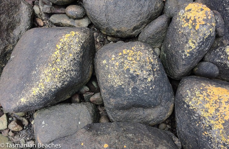
As well, there was dolerite weathering in interesting ways.

Lewisham rock formation along the reef


Quiet place on Lewisham Reef
Quietitude along the reef

Boat Houses

Eventually we climbed up to the path and discovered that one of the particularly  enjoyable aspects of this walk is the number of boat houses tucked into the cliff, each quite idiosyncratic.  Boats lie about on the shore, silently emanating the richness  of their mysterious lives, and jetties are also stop-and-enjoy features along this varied track.  Just like on the Derwent and the D’Entrecasteaux, casuarinas (she oaks) fringe the shore, providing light shade and there are three or four ‘covelets’ depending on how you want to define stretches and pockets of sand divided by man-made features or natural indentations.  Where these exist, so do the boat houses, which in many cases look to be tiny weekend beach shacks.

Lewisham and the view broadens
The tide was not yet out when we reached this vantage point
Lewisham, boat house and boats
After the jetty we came across this  cove.

Lewisham Beach  & Okines Beach (T396)

The path led us  to a beach that a passer by told us was called Lewisham Beach. Sundra was struggling to pronounce the word ‘Lewisham’ and so we agreed that we’d call it the Hamlet of Lewis, which made the place feel pleasantly foreign. I’d thought this particular beach was called Okines but one thing I have discovered about walking beaches is that both they and their names can be transient and confusing.  Sorell Council refers to a Lewisham and an Okines Beach and they should know.  Short (2006) doesn’t reference a Lewisham Beach.  I expect they simply segue into each other and did so without us noticing.

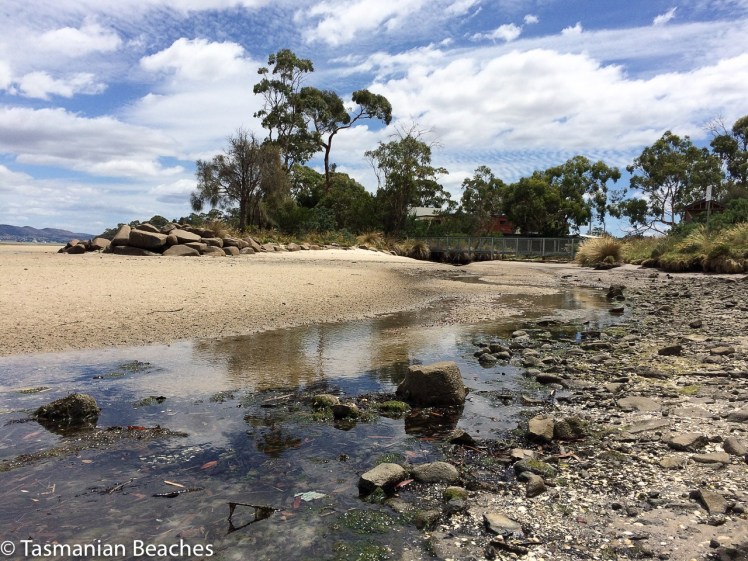
As the tide receded the landscape transformed into vast stretches of sand  interleaved with shallow fingers of water, leaving a deep channel over on the Five Mile Beach side of what a little earlier had been a single stretch of water.   A few groups with fishing rods  had strolled over there  and tiny clicking noises emanated from the entrances of a million tiny tunnels as the more permanent inhabitants of this  sweep of fabulousness, the soldier crabs, began popping up everywhere and marching off together across the watery stretches of sand like endless pink ribbons.  It was hard to find any vacant land on which to place our Gulliver-like feet.

Lewisham Beach and cloud street
Cloud street over Lewisham beach

Lewisham Beach and clouds, shells and water

Transcient Landscapes

We looked at the ripple marks in the sand, practising our reading of tide and current. There were other clues to the life of the beach.  Groins indicated local concern about beach loss and the wrack line showed that this was valid.  It was right up against the base of the dunes and we wondered whether the marram grass and the houses themselves had affected beach replenishment.  Sundra exchanged pleasantries with a landowner industriously chucking branches down to the base of the dune to join the others strewn there in an effort at holding back the weight and determination of water.

We met some walkers who told us they’d seen a large fish head with a protruding tongue and odd curls on its face and although they told us where to find it we never encountered it, just a hoard of jellyfish patiently waiting for wind and water to carry them back out to sea.

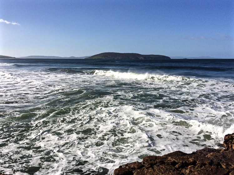
Sometimes the weather and a beach are so compelling that it pays to dawdle and lose yourself in the interesting lives of crustaceans, invertebrates, boulders and curly faced strangers from the watery depths.   We idled and we lingered until at last we reached the rivulet.  We had taken hours, but Dodges Ferry and Spectacle Head were still simply a distant view. and so we agreed we’d come back  on the next good low tide.


Lewisham Beach coastal erosion
Beach erosion at Lewisham
Lewisham Rivulet
Lewisham Rivulet

Okines Beach History

I discovered a little  history on the Southern Beaches Historical Society website.

There’s a natural spring and a wetland behind the beach, which would have once been handy for the Moomairemener who had been pushed out of their country by the time Ralph Dodge, born on Norfolk Island (and one of the group of settlers who came to Van Diemen’s Land in 1807/1808) was granted this land in 1864.  He and his wife Charlotte called it Lagoon Farm and in time it passed to their youngest son, Robert, who with his wife Harriet raised nine children here, before selling the farm to the Crown for the new Soldier Resettlement Grants Scheme that was set up for the soldiers back from World War I.

Ernest Okines was the lucky recipient and as with many beaches the foreshore’s name became linked to the owner.  Today the Dodges Ferry Primary School stands on this land – the old homestead was demolished in the 1990s.


Frederick Henry Bay: Clifton Beach (T408)

Cape Contrariety to Cape Deslacs


Clifton Beach LOOKING TO CAPE DESLACS
Clifton Beach

After slithering down off Cape Contrariety we took off our shoes, Cathy and I, and walked barefoot along the swash, quickly leaving behind the small groups of swimmers and surfers taking advantage of sunny weather. Soon we had the whole beach to ourselves and forgot completely about the existence of the low lying houses between the beach and Pipe Clay Lagoon, except for when we paused to study the sand dunes, their shape steeply altered by marram grass, their mass being gnawed away at by the sea. The dunes extend about 300m inland and reach a height of about 20 m (Short, 2006) and amongst the native bush growing on their backs is Acacia longifolia and the threatened species Cynoglossum australe.  These Cape Deslacs/Clifton Beach dune fields are a geoconservation site of state significance, and Clifton’s Frederick Henry Bay beach alignment is also considered significant.

Especially along some parts of Bicheno Street the houses here are regarded as being at early risk from sea level rise (Sharples, 2009) and sea level rise will of course impact coastal values too and destroy the dune habitat the Clifton Beach community is currently working to preserve.

We studied the ripple marks and read the southerly swell, counting numerous rips and we observed that apart from a lone juvenile Pacific Gull studying our progress this popular beach, facing south- southeast into Frederick Henry and towards Storm Bay was  that day devoid of birds.

When we reached the end we lingered and with a little assistance from Memory Maps pointed out to each other the landmarks we were observing to the south and then we turned our attention to the cliffs at the base of  Cape Deslacs taking stabs in the dark about the pale rock, before guessing at sandstone.  Later I read that there have been numerous drownings at this northern area of the beach, so it’s a wise swimmer who stays within the flags down the southern end.

Our efforts at amateur geology ending in uncertainty, we walked back down the beach contemplating a stroll around the lagoon on a future low tide and pondering the difficulties Cape Deslacs might pose for our exploring.


Further Reading:

Sharples, C.  2009. Climate change impacts on Clarence coastal areas.  Clarence City Council, Clarence.

Short, Andrew. 2006.  Beaches of the Tasmanian coast & islands: a guide to their nature, characteristics, surf and safety.  Sydney University Press, Sydney.


Tasflora. 2012.  Clifton Beach Coastal Reserve: reserve activity plan 2012-2016, draft  (revision 3): advice prepared by Tasflora for Clarence City Council. Unpublished report.

South Arm: Betsey Island: mountain in the water with many names

Betsey Island viewed from Mount Nelson.jpg
‘The Mountain in the Water’ viewed from Mount Nelson

Who are you really, Betsey Island?

Betsey is a hump of island, the largest of the three in the Betsey Island Group and although it is visible from a number of Hobart suburbs, because of the hilly landscape and the peninsulas that surround the city, it often disguises itself as just another bump in the landscape.  Like Tinderbox Peninsula, its reefs were shaped by volcanic activity and on three sides cliffs rise steeply.  It has a small pebbled beach, Black Jack Reef lies between Betsey and Hope Beach and if Tinpot Island, also a member of the Betsey Group, is the sentinel for the Derwent River, then Betsey Island in Storm Bay is a sentinel as you sail towards Frederick Henry Bay.

2 Hope Beach betsey and little betsey.jpg
Betsey Island and Little Betsey Island viewed from the Hope Beach reef

Sailing Betsey

I was pretty excited the first time I took part in one of the 29 nm races from its start at Castray Esplanade in the Derwent River, out around Betsey Island and back to start on a Trad 30.  It remained a favourite race because it left the confines of the river and took in  a stretch of coastline I walked but rarely sailed.

It was on race that I discovered that Betsey Island had a tiny companion, Little Betsey Island, tucked under its southern shoulder and that this little island trails a reef too.  On the lovely Birngana, we came in tantalisingly close beneath Betsey’s eastern cliffs on one race (seabirds swirling above), seemed just behind Hope’s breaking waves on another and, each time I’ve done this race, it’s proved long enough to glide to a halt  on a mirrored surface in the river, to enjoy a reach exhilaratingly heeled, to watch the sea state change time over time with the arrival of catspaws or wild gusts.  Spinnakers up, or reefs in, maybe romping back up the river or stuck at the back of the fleet, the sailing on Birngana was always convivial, the rounding of the two Betseys full of curiosity and wonder, and the fun of the race always continued through drinks and snacks back in the berth.

Confused Identity

Names come and go and play a role shaping  identify.   For the longest time Betsey Island is understood to have been called Teemiteletta or Lore.by.larner.wa.  There is a record of both names, presumably given by different tribes – the latter name seems linked to the Moomairremener, who had a myth about a group of girls who went across to Lore.by.larner.wa to enjoy themselves, but were chased by some men.  To escape them they leapt into the sea and a spirit, Rageoropper, who judged in favour of the girls, turned the men into rock, while the girls swam back to rejoin their tribe. (Go girls! #metoo.)

 Those name givers that made their way over the water to the island as wild swimmers or in their bark canoes left memories of their journeys by way of scatters of shell and stone.  They’d have been seeking mutton birds, shellfish and penguin eggs.  Bruni D’Entrecasteaux, the French explorer, called the mountain in the sea Willaumez Island after Jean Baptiste Willaumez, who was on board the  Recherche with him.

In the 1800s the British came with a heavier footstep and in short succession the island gained a string of new names – Lady Franklin Island, Franklin Island and these days Betsey Island.  It’s possible it may have been named after Betsey, the daughter of Sergeant MaCauley and his wife Maria, who farmed in the Clarence area and were friends with the Reverend Knopwood.

The island was still being used by the Moomairremener in the first years though, because in 1804 an aboriginal man was taken from the island into Hobart and the governor ordered him to be dressed in European clothes.  Luckily he was able to escape that night (Nicholls, cited by Clarence City Council).

In 1814 another group of aborigines were found sitting around a fire on the island and encouraged to visit Hobart.  Again they were inspected by the Governor and given clothes.  After being offended by a local it is unclear whether they were taken to Bruny Island or drowned as they tried to reach it.

Betsey’s Many Uses

In the early days of the colony two convicts were placed there to signal when a ship was sighted, either by firing a gun by day or lighting a fire by night. It was used  as a lookout by whalers.

It also became the home of the offspring of  five rabbits who were on the First Fleet to Australia.  In the 1820s, when the island was bought by a Mr James King, he built himself a stone house, took his water from a couple of fresh water springs and set about  breeding rabbits for the Chinese fur trade, a profound shock to the island’s ecosystem.  His endeavours were quite successful but he sold the island on for 470 pounds to Captain John Bell and Mr Crombie, who continued this business … and while the men sold rabbit pelts to China, the rabbits nibbled steadily through Teemiteletta’s pelt.

By the 1840s the dishevelled island had been bought by Sir John and Lady Jane Franklin for 910 pounds and one of her many creative notions was to establish a botanical garden or game reserve there.  The plan never came together and the island was left to itself, although it was visited occasionally by fishermen and was the temporary hang out of  a handful of deserters, feasting on rabbits and birds, no doubt, while they patiently waited for their ship, the Cicero (American) to leave Hobart.

Then, in The Mercury of 24 May 1876 there’s this intriguing report:

Land Slip at Franklin Island.

A letter received by Mr. J. W. Graves from’James Alexander, better known as ” Old Alick,” who has for some years resided on Franklin Island, recorded an interesting occurrence that occurred there on the 18th inst. Alick states that himself and the boy who resides with him were at the back of the island about four o’clock in the afternoon, when they had a narrow escape of being buried alive.
They had just crossed the flat ground at the back end of the long hill, when the land began to move steadily, ” the same as a ship being launched.” In a few moments an immense mass of earth,’ the best piece of land on the island, fell into the water, leaving, as the writer describes it, “a great gulf.”
Alick seemed very much concerned about it, probably from an idea that at any moment the whole island may disappear in a similar manner.’ He says it does not look like the same island, and wants Mr. Graves to go down and see it. Franklin Island, as is well known, was named after that noble lady who passed away last year;  but the native name of it was Teemiteletta, or, mountain in the water. It was given by Lady Franklin to the people of the colony, and has always been looked upon with great interest. It would be a thousand pities if it was swallowed up in the Derwent.

The Real Owners

Forget the affairs and acquisitiveness of men.  These two islands and the Betsey Reef are now part of a 176 ha nature reserve which somewhat protects its natural owners.  On its rocky dolerite cliffs, with outcrops of sandstone, on its scree slopes, sedgeland and saltmarsh life exists.  White’s skink and the she-oak skink live here.  Birds add colour and music to the open eucalypt woodlands and burrow into the sandier soils but there is only one mammal – the silver-haired rabbit  – that erodes Teemiteletta still – well, at least up until 2002 – but let’s hope the Tasmanian Parks and Wildlife Service has rectified this by now.

In  1985 and 1999, when Nigel Brothers and David Pemberton surveyed the island there were over 15,000 little penguins living there, joined in summer by approximately 150,000 shearwaters.  The penguins, arriving and departing the island risked their lives because both professional and recreational fishers set nets just offshore. It is  outrageous that nets were not been banned decades ago.

232 black-faced cormorant couples also lived on Betsey then.  Kelp gulls were outsiders – only 3 pairs and 11 individuals set up home here.

They saw a white-faced heron.  A pair of sea-eagles had a nest in the eucalyptus forest but wedge tailed eagles also had a presence.  Other raptors included swamp harriers and the brown goshawk and in the Eucalyptus globulus woodland there were spotted pardalote, noisy miners, various honeyeaters, the grey butcherbird, the forest raven, the nankeen kestrel and silvereyes.

The thunder of the human footprint also exists in the weeds that limit Teemiteletta’s life giving generosity.  Boxthorn and Cape Leeuwin wattle restrict the natural habitat available to the amazing diversity of species this small 175.13 ha island supports.

Beautiful Graveyard

I didn’t know when we sailed by Betsey that beneath us lay wooden and metallic corpses, now bejewelled with marine flora.  Old ships need graveyards and since 1916 they’ve been dragged out to Little Betsey Island to create vibrant underwater gardens frequented by divers.    Two of the ships are flattened 1930s freighters now lying off Little Betsey Island reef and a number of harbour vessels lie out to the west.  There’s even a section of Hobart’s old pontoon bridge there.

(For more about the scuttled ships see these links:  Shipwrecks of Tasmania , Tasmanian Scuba Diving Club and the Marine Life Network

Black Jack Snaffles a Ferry

Black Jack Rocks, closely associated with Betsey Island snared a nautical prize in 1994.  Incat, Hobart’s ferry making success story, had been contracted to build Condor 11, a 78 m vessel, but on its trial in Storm Bay on 8 October 1994, there was a navigational slip up  and in the darkness of the night the ferry rushed a full boat length on to the semi-submerged reef – and stayed there for a good two months, its stern and portside hull clear of the water, while repeated rescues were attempted until finally it was freed.

Fish Farms

Change is coming again to the mountain in the sea.  Conscious of the damage done to the D’Entrecasteaux Channel and Macquarie Harbour, fish farms are moving out into Storm Bay.  The proliferation in this area will have a negative environmental and recreational impact on the bay and the island.

Sources:

Brothers, Nigel; Pemberton, David; Pryor, Helen; & Halley, Vanessa. (2001). Tasmania’s Offshore Islands: seabirds and other natural features. Tasmanian Museum and Art Gallery: Hobart.

Clarence City Council.  Aboriginal people and early European activity. n.d.

Clarence City Council.  2002? Early settlers (pdf)

Donnelly, Area.  Bunnies by the billions thanks to one gun-loving Englishman.  The Daily Telegraph January 12, 2016.

HISTORY OF BETSY ISLAND. The Mercury (Hobart, Tas. : 1860 – 1954). Hobart, Tas.: National Library of Australia. 14 October 1913. p. 4. Retrieved 5 January 2016.

Tasmania. Parks and Wildlife Service. 2002.  Small South-East Islands Draft Management Plan 2002, Hobart.  

Textual Silence Project. 2014. A brief history of Betsey Island

Wickham, Mark. 2005.  Entrepreneurship and the management of innovation in the global marketplace: the Incat story. The Management Case Study Journal Vol.5 Issue2 Nov 2005: pp83-93