Walking the Western Shore of the Derwent River: Taroona to Taronga
(This is a continuation from an earlier post)
‘There’s a new bit of track on the Derwent River,’ a friend told me earlier this week. ‘It hasn’t been open long at all and the council hasn’t advertised it yet.’
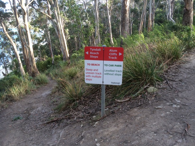
I realized that the trail she was talking about was the much needed link between Hinsby Beach and Taronga Road and so as soon as I had a moment, I went to see for myself. And it was true. The track now leaves Hinsby Beach, involves a short walk along Wandella Avenue, then ducks down into a stretch of forest before emerging at the Shot Tower, where the vegetation is compromised by weeds but the path enlivened by river views across to South Arm. This is a stretch I’d chosen to cycle because walking on major thoroughfares at a distance from the river is an unrewarding experience.
The Shot Tower, Taroona
A steep stretch of downhill comes next, and then an equally steep stretch of uphill. It’s actually not too much of a slog at all and I sat at the table at the top with the geo, enjoying the views before walking along the cliffs, then turning back and doing it all again from the other direction.
The steep section of the track
There’s a clue to why this short piece of track may have taken so long to come into being and my guess is that landowners needed encouragement. ‘Private Property – Keep out’ signs – even one ‘Bloody Keep Out’ sign, line the fences on either side, a small sadness really, when contrasted with the UK and some other European countries where rights of way across private land are well established, well accepted and enrich communities… and I speak as someone with a right of way across our land – it’s never been an issue.
Until you reach the bottom of Taronga Road where this track links in with the Alum Cliffs walk, it feels rather disconnected from the water. But it does provide continuity with other paths and coastal strips and so it is fantastic that someone with initiative on the council has managed to work with the community to create this short but pleasant path.
The path crosses two rivulets, but these participators in the making of this landscape had vacated their beds. The shapes of tiny waterfalls were visible on one, and the rivulet it flows into was napping in a few residual pools.
A stroll in the forest between Wandella Avenue and the Shot Tower
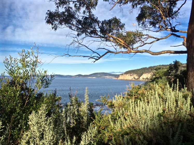
Looking north towardsHinsby Beach from the Alum Cliffs track
I had an assignation with Mr Brown’s River and so it seemed quite appropriate to invite him to accompany me, if only in mind, on the cliff top walk above the Alum Cliffs one day late last year.
That day I’d paused at the beginning of the track, surveying the view from a picnic table above the cliffs while chatting to locals, but mainly, I was quizzing Mr Brown, a drop out medical student from the University of Edinburgh who was thinking about all things floral while his fellow students focussed on cadavers, and whose enquiring mind and botanical obsession had, with a little help from Joseph Banks, brought him here aboard the Investigator in 1801, on Matthew Flinders expedition to discover whether New Holland was one island or many.
There was a breeze, I was ostensibly alone and a single yacht had the white capped river to itself as it headed up river just like the Investigator, which spent some time in the D’Entrecasteaux and the Derwent. Accordingly, Robert Brown spent a lot of time collecting plant specimens from Table Mount (aka kunanyi / Mount Wellington) and along the river, encountering and following the course of Brown’s River in the process. These are my tramping grounds, but on the voyage out he’d visited another of my favourite haunts – Cape Town, where he climbed Table Mountain several times and enjoyed botanising in the fynbos and across the surroundings slopes, including Devil’s Peak.
Defeated by the boulders below the cliffs (see previous blog) it was a whole lot easier rambling along a well formed path that often felt more bushland than clifftop as it wove through eucalypts (silver peppermint and blue gum) and banksias, past epacris in bold red flower, with the companionable little sounds of small birds calling. It’s a sunny and shadowed path with a faintly minty fragrance in places, that occasionally deposits one at the cliff edge for filtered views across to Trywork and Gorringes Points and the long vista through the gap into Ralphs Bay as well as north and south along the river’s two shores. The Iron Pot was visible out towards Storm Bay. I had no doubt that samples of the plants I was walking amongst were included in the 3000 specimens my companion collected and that made their way back to the UK on the very damp Investigator. A conversation between Robert Brown and Charles Darwin, I decided, would have been interesting. They were both lateral thinkers with acute observational skills of the natural world, including geology who spent time here that led to new insights.
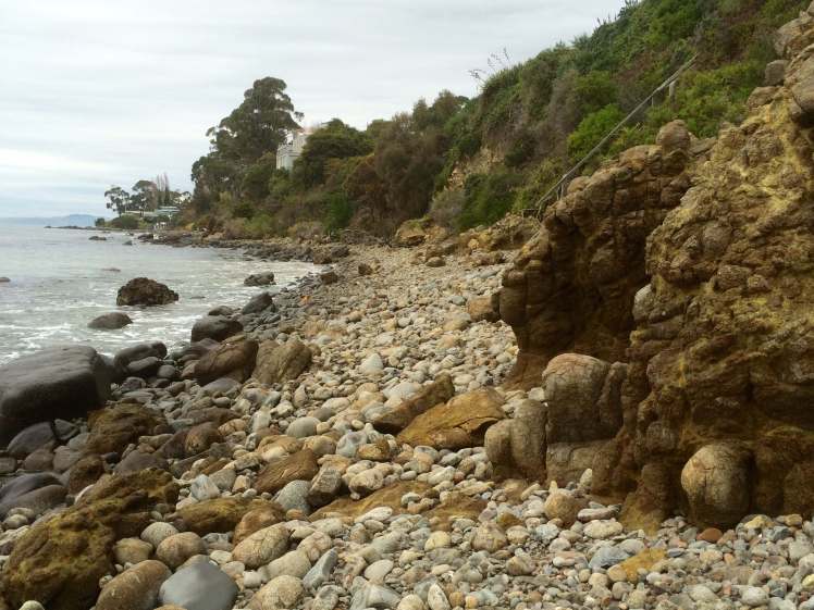
Rock platform below the cliffs
These cliffs, where Bonnet Hill abruptly meets the estuary, are unstable and prone to collapsing into the river along their fractures and faults. They’re siliceous and weather from their greenish-grey to a far paler white, patterned with hues of oranges and lemons. Sometimes oxides and pyrites stain their fractures and as they’re composed of Fern Tree Permian siltstone they occasionally bear fossils. I sauntered over all this rich geology not much thinking about it except to wonder, as I walked by the junction of the Brickfields Track, whether the alum they hold ever found its way into the tanneries that used to line the Hobart Rivulet and made it whiffy back in the early years of settlement. Robert Brown came from Edinburgh, that cold city of stone and so it’s not surprising that geological samples, the substrate on which plants grow, and which moss, a favourite plant of his, is prone to nibble, were among his samples too.
I crossed three small rivulets by way of wooden bridges and passed a few other people out walking that day but otherwise had the friendly solitude of the forest all to myself until, quite unexpectedly, I was out of the forest and crossing a broad and sunny expanse of grassy reserve with lovely views from the bench down to the beach where people walked their dogs oblivious to the fact that they were being observed from up on high. I clambered down the steep steps to the beach. I had left Taroona behind and was now in Kingston, originally known as the Brown River Settlement.
Brown’s River, or Promenalinah, as it was named by the Aborigines who enjoyed its bounty before their lives were rudely disrupted, divides Kingston Beach into two shifting halves and although it’s really a single beach the northern section that has gone to the dogs in the best possible way (although shorebirds would disagree), is known as Tyndall Beach. This section is continuously shape shifting in the most beautiful way. There’s a small cove in the northernmost corner tucked behind a lovely rock formation, it is fringed by vegetation and eucalypts as opposed to the houses and shops along the main beach but we walk it with a heavy footstep and so there are few shorebirds.
Brown’s River (upstream)
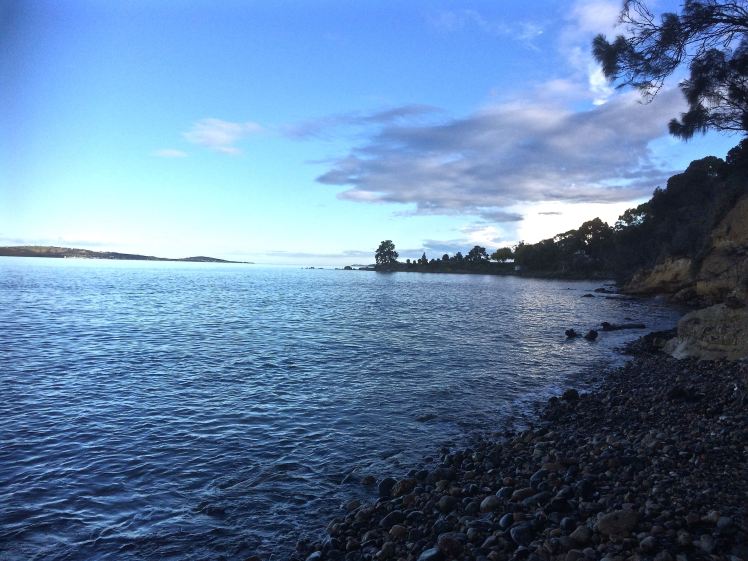
Tyndall Beach looking north
After lingering at the cove, I chose the narrow path that winds through the strip of vegetation at the foot of the cliffs in deference to my companion. A fair number of his new discoveries from this area turned out to have been discovered already by La Billardière on D’Entrecasteaux’s 1792 expedition. The two men didn’t just have botany in common. Conversely, La Billardiere started off with botany but later qualified in medicine.
I crossed the casual parking area between park and beach. Time was against me but the northwesterly was due to swing south westerly so at least I’d have the wind at my back on the return walk. And so there I paused on the footbridge over Mr Brown’s River contemplating both it and the floodplain it has carved between Bonnet Hill and Boronia Point. The tannin in the river makes it whisky coloured. It rises on kunanyi and I’ve followed much of its course, from above Silver Falls, down to the estuary. It runs narrow and free down the slopes (although some of its water is detoured into Hobart’s water supply) and then it weaves through its floodplain.
Robert Brown found the river when Aborigines still camped here and enjoyed the river’s largess and the hunting to be had behind the beach. There’s still a remnant wetland and there’s still the remnant bush I’d walked through, but my eyes took in an urban landscape – houses smothering the floodplain, and houses on the surrounding hills with their gobsmacking views. Looking down from the Channel Highway, the clubhouse of the golfcourse is the Red House built by John Lucas way back when. He was a a member of the first settler family to acquire land here. They picked up several hundred acres of land around Brown’s River and it’s on this land that, in about 1808, Kingston began to take shape. (For a historical perspective see the photos below). He found other things to, being the first person to describe a living cell nucleus and observing the tiny random movements of miniature particles down his microscope. You learned about this in Biology. It’s named after him – Brownian motion.
I retraced my steps, trailing my companion but mingling with modern day locals using the track. With the arrival of the south westerly the river grew wilder and the forest canopy transformed into an orchestra of wind instruments. I hoped the trees would hold.
I once took a walk in Eastern Turkey with a friend. That path was the only link between two villages. It crossed a shallow river that my friend traversed on a donkey. There were caves where hermits had once meditated; the way we were walking was thousands of years old. The Alum Cliff track links Taroona and Kingston but it is purely recreational. It’s quite possible that Aboriginal feet originally made it but I don’t know this to be a fact. Even though these days the purpose of footpaths has diminished, in the same way that arriving at an anchorage by boat is so different in feeling from arriving by car, so is it different arriving at a well known destination by foot.
There are at least two suburban developments in Hobart that would have thrown Robert Brown into an apoplectic fit behind his desk in Joseph Banks’s library (he became its librarian). One is Tolmans Hill, completely natural not that long ago. The profound shock when the first house appeared up there! The dismay as the suburb grew. The other is the small enclave above Tyndall Beach that doesn’t really belong anywhere but has further eroded the landscape Robert Brown found so rich and strange. This used to be native bush but subdivisions continue to happen on Bonnet Hill and in the fullness of time the land still open land looks set to disappear.
Historic Photos of Brown’s River (Source: LINC Tasmania)
They were mine for paddling, and kayak along these cliffs I did, before discovering sailing and long before embarking on this humble little project. Now, standing on Hinsby Beach gazing south along their tall and shadowed extent, I wondered about the possibility of actually walking along their base. I’d once assumed the Alum Cliff track that begins at the bottom of Taronga Road on Bonnet Hill was the only way. Now I was not so sure.
Alum Cliffs from the path above Hinsby Beach
The coastline south from Hinsby Beach to Kingston is known as Alum Cliffs; the hill’s abrupt and perpendicular descent into the river. There is no beach at its feet, just rocks and boulders, as well as a rocky platform containing fossils beneath Taronga Road (a cul de sac that runs from the Channel Highway down to the edge of the cliffs not too far north of the point where the highway – in reality a narrow semi rural road – begins descending down to Kingston Beach).
Rocky platform, Alum Cliffs
I knew about this fossilised platform from chats with locals on Hinsby Beach and from Sue Mount’s article. They said that once it was possible to reach it on foot but a local landholder had built a fence that now excluded the public. Did they mean from their beach, or, in hindsight, did they misunderstand me and mean from Taronga Road? Exactly how you accessed this platform wasn’t too clear but I was determined to try.
Many years ago, when I was deeply into archaeology I walked the Brickfields Track (also accessed on Bonnet Hill) with the Tasmanian Archaeology Society. The Taronga Road area has mudstone, dolerite and a patch of quality sandstone along its ridge and is strewn with evidence of early colonial activities.
On that walk we came across remnants of the Brown’s River Probation Station (1840s) where over three hundred predominantly road building convicts once lived. There were the remains of a kiln used for brickmaking. Bits of the station are scattered through local gardens now and there’s a house with a swimming pool built into the old quarry. As the years have unfolded some of the bricks once part of structures or left lying about have been removed and incorporated into new structures or lost altogether. Some have no doubt ended up in the river. On my earlier walks I’d encounter red bricks remoulded into satisfyingly round and textured shapes by water.
On the Channel Highway, close to Taronga Road, there is still evidence of an old convict built wall. Some of that high quality sandstone (by Tasmanian standards) from the Taronga Ridge became the Shot Tower, locally famous for being the last remaining circular standstone shot tower in the world, built in 1870, almost twenty years after the probation station had become redundant. It, too, eventually became redundant but in its heyday was used for producing lead shot.
Kayaking, you can get much closer to the cliffs than when you’re on a yacht, although it can be unpleasant when the waves rebound strongly off them. On a yacht it’s best to leave a little seaway, especially along a lee shore, and when I pass by Alum Cliffs these days I’m usually sailing, observing these dark cliffs rising from the water, more wildness in the city precincts, topped as they are by communities of trees and shrubs forming a satisfying stretch of bushland.
There was a strong north westerly wind blowing on the first day I first set off to uncover a route along the cliffs from Taroona itself and I was feeling uncharacteristically despondent, in need of an activity to blast that mood away. Sue Mount’s article seemed to be a hint that the Alum Cliffs track had once started at the right of way onto the beach at lllawong Crescent. I’d looked at other brochures and I’d looked on Google Maps. None of them show it starting at this point.
But still I searched. I returned to the start of the Hinsby Beach track at Wendell Crescent. I walked down it and saw that there was in fact a path to the right that went along the very edge of the cliff, somewhat steep and slippery. I got as far as a patch of escaped daisies from the garden above. They were growing over the track and to proceed I had to grab hold of vegetation to pull myself upward. It wasn’t clear that the path continued on the other side so I decided that as I was alone and the path a tenuous, unused one so hazardously close to the edge, I’d best go up to Taronga Road and see if I could meet up with it by heading north.
I was enthused by the discovery that I could indeed head north to Taroona on the Alum Cliff track but I was not far along it when I met a local walking her dog, one like Ash, and so we got talking. She confirmed what I had already learned: that once it had been possible to take a path down to a large rock platform at the base of the cliffs hereabout and continue along towards Taroona, but it had been closed off by a landowner. If I continued along this path I’d reach the Shot Tower.
‘And it’s steep,’ said a man I encountered a little further along, and he was right. I came to a point where I had a clear view of the path heading downhill and then up the other side. My focus is on beaches and the stretches of coastline between them, and with these beaches it’s on the river itself, particularly (but not only) where it interfaces the land.
I declined the path’s feeble invitation and turned back.
On the rocks below Alum Cliffs
This was back in June 2015. Since then, I’ve gone back to Hinsby Beach on five or six separate occasions, all on the most promising of low tides, sometimes in winter but also at the supermoon’s low last month (9 March), when, unfortunately, the seabreeze worked against me, hurling waves at my knees in a quite malicious fashion as I tried to negotiate a watery gap in the rocks close – very close, I feel – to the little turn the cliffs take as they head to the area beneath Taronga Road. You’ve no business to be here, I felt they were saying. You people have made your track, now walk it.
But that day beneath the supermoon, I sat for a long time enjoying my splendid isolation, looking back towards Hinsby Beach, marvelling at seeing the cliffs with so much more of their base exposed, and enjoying their powerful presence at my back. They are not the only cliffs in the world. They are not even spectacularly tall but all the silence of the ages they contain gives them an undeniable aura in which I basked while deciding that, feeling personally rejected by the cliffs and the river, reaching the rocky platform and climbing up to Taronga Road wasn’t going to happen. The track above the cliffs is there for a purpose, I could only agree, and it affords a different vantage point from my watery stamping grounds. I decided with regret that I’d be satisfied with that.
Dropstone and periwinkles
The rocks below Alum Cliffs
And so that walk along the top of the Alum Cliffs from Taroona to Kingston is the subject of my next entry.
The places I’ve identified have given me the slip so I’m mentally doing circles around High School Point and the beach some call Beck’s, some call Melinga and some call nothing at all to have a little think about the local expression of the human mind.
This is because in misleading myself when it comes to naming, I’m sure I’ve misled you. Perhaps the cartographers, surveyors and the Nomenclature Board have not chatted enough over tea breaks or scheduled sufficient meetings, given that for many years they’ve been part of the same division in the same government agency. This occurred to me because more research this past week indicated one of two things: 1. I’ve misinterpreted local writers’ beach identification or 2. The locals simply cannot agree, are occasionally geographically challenged and at other times are simply not precise enough to help confused readers out. A case in point, Karringal Court is not south of High School Point as one of the authors I read would have it. Whatever, the maps themselves have so very little to say!
Nomenclature, generally, is further complicated because where no formal name exists the Aboriginal community have naming rights. But they are made up of several communities and they don’t all know a place by a single name. Take the Derwent River itself. It has more than one Palawa name. According to a member of the Channel community, their name for the river is unlikely to be formally recognised. I was given this name on a small piece of paper I can no longer find, which is a shame. The name is beautiful.
The second point of difficulty is in negotiating on names with government. I had a chat to someone from the Aboriginal Community when I was at Risdon Cove. They said the government drags its feet. I spoke to someone in government. They said it’s hard to get representatives of the Aboriginal community to the table.
I revisited the foreshore and was pleased to encounter a local who told me he’d been walking these beaches since 1948. An expert, surely!
’Becks, Dixons and Retreat,’ I asked. ‘Can you confirm I’ve got them in the right order?’ He looked at me blankly.
‘I’ve never heard of them,’ he said. ‘The one you’re calling Beck’s I know as Melinga Place Beach. Why would it be called Beck’s anyway?’
I went home. I reopened my books and I clicked through web pages. I rediscovered an article by Reg Escott on the Taroona Book Digitised website, who in his article on Taroona’s boat sheds explains that Taroona has five beaches. Starting at Grange Point, they are:
Retreat Beach [my impression was that he means the whole long strip starting from Grange Beach (not named) and ending at Retreat Cove, the northern beach on ‘High School Point’]
Retreat Cove [the one I thought was Dixons, on the northern section of ‘High School Point’]
Dixons Beach [in front of the high school, south of ‘High School Point’]
Beck’s Beach [Melinga Place beach]
Taroona Crescent Beach [Taroona Beach]
Hinsby Beach.
Have a look for yourself. It’s an interesting read if you’d like to know more about boat sheds (of which there were many more in the past) – or are keen to stumble across a clue or two as to the interesting placement and formations of boulders / rocks around these beaches. They have been moved, post invasion/settlement.
I came to two conclusions.
Beach identity is (always) in a state of flux along this shoreline. For eg, Beck’s is named for a land owner (and perhaps before that was called Mitchells after an earlier owner bearing that name) but now it’s transitioning to being named for a street. Dixon had a farm somewhere in Taroona.
We keep messing with the landscape. Had the road not been built down to the shoreline, Beck’s and Dixons (if I’m identifying these correctly) would be one beach.
But, guess what? I probably still don’t have the order right. This morning I revisited the Taroona 1:25 000 map (no 5224) and this is the nomenclature that’s listed, north to south:
The Grange Picnic Area (at Cartwright Point! Go figure.)
Cartwright Creek
Cartwright Point
Dixons Reef (in the region of Karringal Court)
Dixons Beach (which I’d figured was Retreat Cove – see above)
High School – the site indicated but the point not named
Crayfish Point
Taroona Beach
Alum Cliffs
That’s pretty meagre and laxadaisical, if you ask me, given this map is supposed to be authoritative. What’s more, The Listmap, supposedly the most current source, given that it’s online, has even less information! And so I’m giving up. Here, in this city of 250,000 people more or less, we know and care so little about the coastline we haven’t named it up. The alternative view is that the coastline rejects our spurious naming methodology, if it can even be called that. Why name something so grand and long enduring after unexceptional land owners? Why name it’s spots but not it’s freckles?
I like the view of the coastline slipping free of its transient names, even though names would be so helpful when you want to text your lift your whereabouts. May it stay wild and secret in the city forever. And perhaps Andrew Short who numbers the beaches, and my friend, who is fine with degrees of latitude and longitude but not with names have a point because if we’re not in a relationship with the coast, and we don’t value it, then it’s nothing but a nameless stranger to us after all.
The moon rising over the boulder at Grange Beach
Apart from the links above, see the Place Names Tasmania database. Here’s the official document on the rules with regard to assigning Tasmanian place names.
A detail from this walk: mussels and limpets exposed by the tide
The eucalypt that had confused me as I approached Grange Beach a little earlier in the walk had done so because my next waypoint, already known to me, was another bleached eucalypt lying prone across pebbles and sand, supported on the tiptoes of its branches. But now, walking along south of Grange Beach I was still trying to clarify the coastline in my head. Where, really, did Grange begin and end? Why was what I was seeing not according with what I’d read in Short’s inventory?
I rounded a slight point and finally reached the eucalypt I’d encountered the previous Sunday, a day that had begun sluggishly because I’d been reading Cheryl Strange’s book Wild, about her long walk down the Pacific Crest Trail, well into into the early hours of the morning. It had made me itchy to get out and walk beaches again, especially as so much of my time had been spent on Samos, back in the water finally after a long time on the slip, but still needing new batteries and a new anchor. Down at the boat that Sunday, ready to do some work, the geo and I realised we could do nothing – the shipbuilder had one of our keys and we’d forgotten the other – and so, with just a short space in my day before heading off on a beekeeping course, I’d set off on my initial sortie into Taroona to identify beach access points.
I’d parked the car at the southern end of Flinders Esplanade and found a path that led down to the beach beside a double story house. This path followed the short, steep edge of a gully that was the home of a rivulet. At the bottom of the cliff a huge, bleached eucalypt tree stretched across the sand. On the other (southern side of the rivulet) another path ascended.
The prone eucalypt at the bottom of Karingal Court
I thought initially that I was on the beach that Short calls T458 (aka Blinking Billy Beach 3 – yep, I know; I was very confused!) because he describes that as being a narrow reflective sand and rocky beach that extends along the base of 20-30 m high bluffs for 200m. Only this wasn’t that long – or then again, maybe on a different tide it was? I also thought that it might be T459 which he describes as extending south of the sloping 20m high Cartwright Point. When I read this I still thought that Cartwright Point was actually High School Point visible in the distance, so it didn’t make sense. (He says of T459 that it’s a narrow eroding beach, is backed by vegetated bluffs that rise to 20m in the south, that there are houses on top of them and steps at the northern end. Not knowing the shoreline to the north at all that Sunday, I decided for the time being that this was the one I was on, not thinking twice about the steps at Grange Beach.
Welcome to my geographically confused world!
I hadn’t had time on that Sunday visit to walk north of the eucalypt, otherwise I’d have realised then that in the absence of a firm nomenclature there are different ways of viewing the coastline. Short, it seems, has taken a larger coastal/geomorphological perspective and identified longer strips – the three Blinking Billy Beaches with the third extending to Mitah Crescent (I think), and Dixons extending south from Grange Avenue to Taroona High School and High School Point. It was only when I revisited on a summer spring tide that I saw that on this strip Grange, Karringal and Dixons really do become one.
Karingal Court, Grange Beach, Dixon Beach merge on a spring low tide, Jan 2016
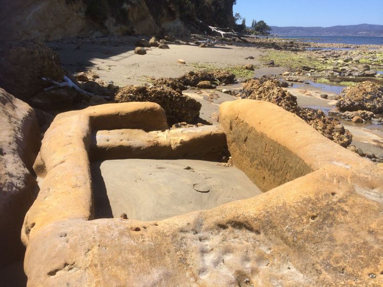
That Sunday, I simply walked about on the shrunken sandy portion of the beach as far as I could go, which wasn’t far as the tide was quite high. It was indeed narrow here, and as you can see, there are a lot of cobbles and sand and a reef. I found a quite astonishing square rock pool carved into a huge boulder that looked at first like a boat and then like a plane. It’s at the southern end close to the geologically interesting cliff that barred my way further south on that particular tide.
So on my long walk I sauntered along knowing that at some point I’d see the bleached and fallen eucalypt below Karringal Court and when I did the somewhat longer beach thrilled me just as much the second time, although I paused with concern to reconsider the dank little rivulet trapped behind a buildup of pebbles.
Revisited: The beach below Karingal Court on the spring low tide, Jan 2016.
From here I could see past the pebble strip I was on to how the beach I assumed was Dixon’s curves to the point at the High School and that, in fact, this wasn’t all that far away.
There is a path you’re encouraged to take as your near the high school, but I’d come back after my beekeeping course was over, and walked that then, trying to shrug off a small despair that had nothing to do with the keeping of bees. That path sometimes uses streets, sometimes paths through bush and across grassy spaces, and sometimes brings you to cliff tops and as a result I was beginning to wonder about the geography behind the beach too.
Rather than choosing this path again I continued along the pebbles beneath tall yellow, unconsolidated cliffs before I stepped onto the beach that I’d identified as the one Sue Mount refers to as Dixons, but which, on a more recent visit, some locals spread on towels told me they simply call High School beach. They did not know it had another name.
High School Point from Karingal Court beach, Taroona
As I walked along Dixons I kept a closer lookout for middens but the evidence I found was frail and barely present. I stopped to try and make sense of a layout of rocks that brought fish traps to mind, but if Tasmanian aborigines did not eat fish from 3700 years ago onwards – there was a dietary transition at this point (Johnson & McFarlane, 2015) – then why would they have built a trap, if that’s what it is? I must be one of many who have thought about this because on that later visit one of the people I stopped to chat with on this beach had wondered the same thing and as archaeologists have visited the midden on Dixons, they must have regarded/disregarded this feature too. It doesn’t feature in Jim Stockton’s Tasmanian Naturalist article on the matter.
I rounded the point I thought was Cartwright’s, puzzled, because it was disassociated from the reserve to which it was supposed to be attached. Instead the school grounds rise behind it. Is there a school anywhere else in Australia that has such a fantastic setting – surrounded by two beaches and a third (Retreat) across the road really just artificially divided from the other two?
There was a small cluster of seabirds hanging out on the boulders at the point (not Cartwright’s at all, but High School Point, just to be clear). There nearly always are seabirds here and, buoyed by this fabulous walk, I adjusted the pick up arrangements and then I carried on walking.
(Andrew Short’s report is referenced on The Bookshelf page).
Johnson, M & I McFarlane. 2015. Van Diemen’s Land: an aboriginal history, UNSW, Sydney
Our story is in the land … it is written in those sacred places … My children will look after those places, That’s the law.
Bill Neidjie, Kakadu elder.
In quite quick succession, with the cliffs far lower now, I was passing large houses and small boat sheds and from the Mouheenener Sentinel (see part 3), where the view of Taroona began to open up, I was particularly preoccupied with the lack of birds, the non-stick nomenclature and the dimensions of the shoreline – what was a beach and what a separating reef, had totally befuddled me because I could not get them to accord with my memory of what I had read of this section in Andrew Short’s vast inventory of beaches.
Taroona in my sights
This estuary is expansive and should be rich with life. Not so far away the Derwent merges with the waters of Storm Bay and the D’Entrecasteaux Channel and yet it struck me with some force that birds had not been a presence on my walks – a handful of gulls, a cormorant, an oyster catcher of two, a heron, period. This shoreline seemed as good a place as any to encounter great avian flocks but this was far from being the case. I was thinking about how the early explorers recorded the migratory short tailed shearwaters darkening the skies as their huge flocks passed overhead for days on end, and their descriptions of the river alive with whales and fish so that there must also have been huge numbers of gannets, gulls and cormorants diving. There were also a great number of land birds, some now extinct (eg the Tasmanian emu), available for hunting through the she-oaks and the eucalypts when the colony began so that it can seem, reading the literature, that the Reverend Knopwood’s gun was only silent when he was enjoying convivial drinks in town or sermonising from his pulpit. But it’s winter, I reasoned. Maybe that’s part of the problem. Perhaps the remnants of those great flocks are still sizeable and are occupying themselves elsewhere.
Even as I approached the Sandy Bay-Taroona boundary which I assumed was the bend in the road near the Truganini Reserve, I was still pretty clueless as to my precise whereabouts but I did know I was about to leave Sandy Bay, and so, to illustrate the difference between the rivulets of the past and the present, a final quote:
‘By the 1830s, despite still having the reputation of a smuggler’s resort, Sandy Bay began attracting enterprising, law-abiding free settlers. One of the greatest advantages of the river-side suburb was the clean water from its many little streams. The Hobart Town Rivulet was already a miasma of rotting carcasses and filth, spreading disease and death, and the merchants in Hobart Town saw the advantages in moving their families out of the township.’ (Goc, p. 87)
I came to a stretch of eroding yellow cliff and there again was a rivulet stifled by a tangle of exotic weeds and creepers, forming a dirty pool from which a mere trickle emerged and entered the river. It was only afterwards, when I was researching that I learned that this, for sure, was Cartwright Creek and that the pretty little cove just a short stroll south, sheltering in the elbow between this strip of shore and the sloping point, was the start of Cartwright Point. I had thought Cartwright Point was at Taroona High School and so, when I did the walk, I could not place this rivulet or the cove.
A little path descended beside it and I walked a short way up it and looked about – and came face to face, yet again, with my blindness to landscape. There was a park up there. And this modest rivulet had clearly enjoyed making itself a deep bed. This was precisely where the road curved and Taroona began.
Cartwright Rivulet
I have driven along Sandy Bay Road a zillion times, thinking about a zillion different things but never about the green space on the downward slope of that bend in the road. The Truganini Reserve is on the other side – and in fact, it’s where Mount Nelson slopes down to the river at a fairly steep gradient because of the gully carved along its side by the rivulet. Had you asked me, I could not have told you that this park is the Pierce Reserve or that it follows the banks of Cartwright Creek, a rivulet that has its source on Mount Nelson, enjoys sunlight and moonshine all the way, except for where it passes under the span of the road. It would once have contributed delicacies from the mountain top to the river it was merging with. These days it’s shabby and sick. If it was our pet, we’d be up for animal cruelty charges. If it was our god, bad luck would rain down on us…
I made a note to self: find out more about this rivulet – and when I did, I was to discover that Mr George Cartwright, who along with his brother owned several farms on this shoreline and was ‘father of the Tasmanian bar’ was himself sometimes out of order, in front of it for striking fear into the hearts of his neighbours.
The view from the Cartwright Point area. This yacht had kept pace with me for much of my walk.
Although I felt chastened by my ignorance, I also had a sense of anticipation because I thought I knew what lay around the corner of the point, but I was in no rush to get there. Cartwright Point is pretty and has the feeling of a private beach. It was nice to linger. I could not have been happier.
Looking back at the cove at Cartwright Point
I scrambled over boulders and requested right of way from a fallen eucalypt that lay across my path, and then I was on another beach, known but not known, grappling with another name, perhaps because Andrew Short and I viewed the beaches years apart and on different tides, perhaps because he numbers the beaches but doesn’t always mention them by name, perhaps because beaches can be tricksters… or maybe just because beaches are a human construct anyway.
Source:
Goc, N. 1997. Sandy Bay: a social history. Gentrx Publishing, Hobart.
Short, A.D. 2006. Beaches of the Tasmanian coast and islands. Sydney University Press, Sydney.
“It is life, I think, to watch the water. A man can learn so many things.”
― Nicholas Sparks, The Notebook
My favourite beach is usually the one I’m standing on, lying on, sitting on, swimming off, kayaking by or sailing past no matter where in the world I may be but truly, there is no best beach in the world. Beneath the most polluted and abused appearance, beneath that mangrove mud, despite those heel busting pebbles, all beaches are good, are beautiful as Tasmanians will testify about the beach that once held a lake but now lies drowned at the bottom of a dam.
I love their shapeshifting nature. I love the element of surprise a beach throws up, if not in an altered shape then by the unexpected flotsam and shells suddenly exposed. I love the intoxication of salty air suspended above crashing surf or still water in sheltered coves. There is nothing about a beach not to love except when the waves are at your ankles and the cliff at your back.
When the centre isn’t holding, when disintegration within, without, and all about fast forwards, a beach is a good place to go to elongate time, to contemplate the underpinnings of things, to return to what is real and simple and beautiful.
For a small island Tasmania has an abundance of beaches. I’d done my first walk for this blog before I discovered that Andrew Short had long ago realised this. He became acquainted with them in 1990 and 1996, walking them, measuring them, counting them. But they’ve changed. The sea is having its way with the dunes and there have been changes wrought by marram grass, recreation, marine farming – all sorts of human insistences and arrogances founded in ignorance.
Tasmania also has a plenitude of islands. There are the larger islands most Tasmanians know – Flinders, Cape Barren, King, Maria and Bruny – and then there the scatterings of island groups, most with a beach or two at the very least, but some rock alone with seal haul outs and seabird rookeries.
Long ago, long before I discovered Andrew Short’s work and his astounding figure of 1,269 beaches on mainland Tasmania (with a further 348 on a few selected others) I’d thought of creating a beach blog. I started taking pictures of the ones we were walking – Verona Sands, Half Moon Beach, Nutgrove, Cosy Corner – but this project quietly died before I’d even selected my blogging software – or stopped in disbelief before that daunting number – 1,269. That was a hapless, short lived effort and I hope this time I do a little better.
This week I attended a conference at Wrest Point Casino in Hobart. It’s built on Chaffey’s Point (aka Wrest Point) with beaches to the left of it and beaches to the right, the suburbs behind where once there were forests and behind the largely built up foothills the mountain, a reminder still of what the land closer to the river once was like. We talked about living and dying while engaging in creative pursuits while outside the Derwent flowed, the seagulls sat on rocks and watched it and our small yacht lay tethered to the marina rocking on that timeless water.
I like the notion of trying to live each day as though it’s your last but it can be hard to achieve. When it happens it can infuse a little intensity into life, a little like a threatening diagnosis can make life feel richer, poignant, and totally desirable at that point of potential loss, or conversely, how being fully immersed in a creative project illuminates a day and brings together apparently disparate events and objects. Beaches, rivers and the sea. I thought that if I knew the year was going to be my last then along with people and animals I would surely include books, boats, beaches and waterways.