Derwent River: Kingston’s Whitewater Creek: Beautiful and charismatic. Skinny, bruised and battered

Kingston Beach and Whitewater Creek

Three of us rode from the mountain to Kingston Beach, land once shared by the Mouheneer and the Nuenone  but now an ever expanding suburb south of Hobart.

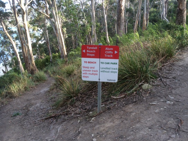
The rivulet track was a loose, slithery surface beneath the forest canopy, Strickland Avenue a fabulous swoop, the linear park serene, Sandy Bay Road provided a cycle lane, the Long Beach precinct a bounty of birds – swift parrots, galahs and cockatoos in the tall eucalypts, Taroona a snack and Bonnet Hill the exhilaration of views and the final descent down to Tyndall Beach. We crossed the footbridge, rode along the Esplanade and headed on to the sailing club beneath Boronia Hill.

Kingston Beach

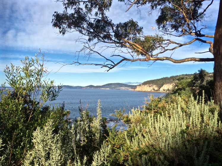
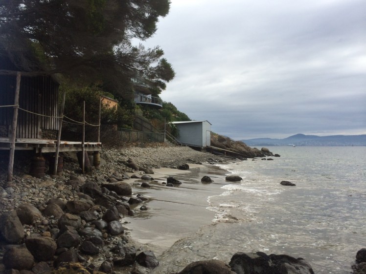
Kingston Beach lies between Bonnet Hill and Boronia Hill and it is beautiful and charismatic. Unlike many of the pocket beaches of the Derwent that come and go with tides and the seasons and are hidden away down side roads, it’s a focal point.  It has a eucalypt lined esplanade, a road running past it, beachside houses and a small but popular café strip.

Esplanade Kingston Beach

The beach lies open to Storm Bay, staring it straight in the face like an ocean beach and small waves lure people into the water even on some of the coldest days. The fetch is wide here and as Sydney to Hobart yacht races are often lost or won on this last stretch up the fickle Derwent, it pays to know the way landforms shape the flow of wind and water.

Facing Storm Bay, Kingston beach

The beach has its offshoot, Tyndalls Beach, running below Alum Cliffs, it has Browns River, arriving from its source on the mountain, visible in the background, by way of the Summerleas Rd valley as well as via Vincents Rivulet that flows along Proctors Road beneath Albion Heights. And it is a generous urban stretch of blond sand that stops at a rock platform where the sailing club is based, just below the headland of Boronia Hill.

Tyndall, Brown's and Kingston Beach
Brown’s River separates the beach into two.  Kingston Beach is on the right

But I’m interested in things less obvious and so to ponder the beach and its environment I went walking with my canine companions, down a path whose sign I’d previously ignored.

If Kingston Beach is the beautiful extrovert in the room, then the myriad of rivulets in its hinterland are shy and unassuming – Fisher, Coffee, Dunns Creek and the like. Whitewater Creek, while actually bearing signage and showing evidence of community adoption, is mysterious, and on first appearance gives every impression of being the skinny, bruised and battered victim in the corner.

Whitewater Rivulet

We walked beside it from the Summerleas Road entry point, across a small bridge where, curiously, the rivulet goes two separate ways, and followed its leftward flow until we reached the entrance to an underpass, where signs amongst planted native vegetation explained that the pool in front of me was part of Kingston’s stormwater treatment plan. But the walk was desultory. Running behind houses on one side and the weed-choked creek on the other, it struck me that if there was an emergency number you could dial for a creek then I would be ringing it. Even the dogs seemed subdued. This was no path for an uplifting walk, I decided, but I would come back and ride it.

The next day I was back with my bicycle and the stretch we had walked (seemingly flat) turned out to be a long, descending gradient. With the wind at my back I was through that ugly underpass in no time at all, and continued my descent into Kingston.

And this was where Whitewater Creek showed me a different face. That stormwater pool was the first of many and when I crossed the highway and cycled down a path I’d never noticed before, I found myself weaving around a series of beautiful ponds, happily enveloped in flourishing native vegetation that local birds, including Tassie hens, were enjoying. There were sculptures, but most heart-warming was that the Kingston community was taking creative and active steps to make sure that the water spilling out of the creek and into Brown’s River was clean when it got there. I thought about poor, filthy, Sandy Bay rivulet. If only it, too, had this sort of support. Was there not scope for a small stormwater pool to be created somewhere along its urban extent?

IMG_8199

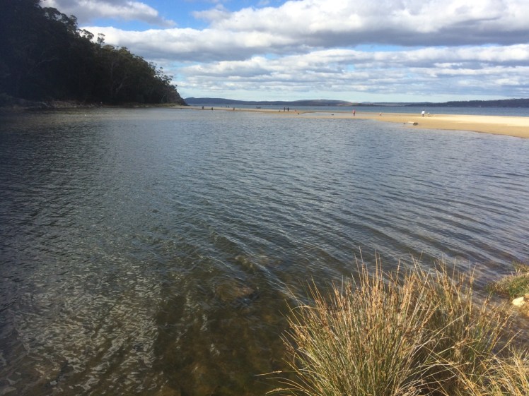
I stopped for an ice cream at a café on the beach, then rode back into the wind and through the ponds and under the highway to the point where the creek diverged.

The rivulet and the track crossed Summerleas Road and I figured I must be headed towards the Fork in the Road. Tassie hens, a curious horse and browsing cattle turned out to be more visible than the rivulet itself, particularly as the path began to climb and close in on the highway. Beside a bridge it veered right and dropped me on to Spring Farm Road but I remained puzzled. All the other rivulets I’ve encountered take the most efficient course to the estuary but this wayward rivulet seemed to be having it both ways, travelling across country into the Blackmans Bay catchment.

Whitewater Creek track south

I discovered that Whitewater Creek has a deep and ancient secret as the Mines Department discovered when surveying for a dam on its upper reaches in the 1970s. They discovered back in the there Tertiary era,  far below the present horizon, another creek flowed beneath it in a ‘buried valley  filled with sand, clay and gravel’. They traced it to Pritchards Road where it joined with an eastern tributary valley discovered in 1969. From here the water flowed south through the saddle between Doctors and Little Parks Hills (new names to me) down to North West Bay.

Well, who’d have thought?

‘From what had been up to this date strictly a dam site investigation widened in an attempt to trace the main Tertiary valley south to North West Bay and the two tributary valleys upstream into the two reservoir areas of the proposed dam sites on Whitewater Creek (Dept of Mines, 1979).’

Apart from learning a little more about the geology and geography behind Kingston Beach, I discovered the importance of geological surveys before you build a dam – leakage can be caused by an unfriendly geological substrate, like the faults this area is full of, and can render your dam useless.

I turned to my maps and saw that flowing south, it meets up with Boddys Rivulet to bring life to Leslie Vale, before flowing ultimately into North West Bay.  Here were secrets I hadn’t known but now the course of the rivulets down from the mountain and the remnant vegetation around Brown’s River inform my view of what this landscape once looked like.

IMG_8212
Brown’s River: the view north, an indicator of the forests and wetlands that once inhabited the floodplain behind the beach


Source:  Tasmania.  Dept of Mines. 1979.  Whitewater Creek dam sites, Kingston and the Tertiary channels of the Kingston-Margate area. (Geological Survey ; Paper No. 3)

Derwent River: A Short Walk with Mr Brown

Taroona to Brown’s River

Looking north towardsHinsby Beach from the Alum Cliffs track

I had an assignation with Mr Brown’s River and so it seemed quite appropriate to invite him to accompany me, if only in mind, on the cliff top walk above the Alum Cliffs one day late last year.

IMG_3494

That day I’d paused at the beginning of the track, surveying the view from a picnic table above the cliffs while chatting to locals, but mainly, I was quizzing Mr Brown, a drop out medical student from the University of Edinburgh who was thinking about all things floral while his fellow students focussed on cadavers, and whose enquiring mind and botanical obsession had, with a little help from Joseph Banks, brought him here aboard the Investigator in 1801, on Matthew Flinders expedition to discover whether New Holland was  one island or many.

There was a breeze, I was ostensibly alone and a single yacht had the white capped river to itself as it headed up river just like the Investigator, which spent some time in the D’Entrecasteaux and the Derwent. Accordingly, Robert Brown spent a lot of time collecting plant specimens from Table Mount (aka kunanyi / Mount Wellington) and along the river, encountering and following the course of Brown’s River in the process. These are my tramping grounds, but on the voyage out he’d visited another of my favourite haunts – Cape Town, where he climbed Table Mountain several times and enjoyed botanising in the fynbos and across the surroundings slopes, including Devil’s Peak.

Defeated by the boulders below the cliffs (see previous blog) it was a whole lot easier rambling along a well formed path that often felt more bushland than clifftop as it wove through eucalypts (silver peppermint and blue gum) and banksias, past epacris in bold red flower, with the companionable little sounds of small birds calling. It’s a sunny and shadowed path with a faintly minty fragrance in places, that occasionally deposits one at the cliff edge for filtered views across to Trywork and Gorringes Points and the long vista through the gap into Ralphs Bay as well as north and south along the river’s two shores. The Iron Pot was visible out towards Storm Bay. I had no doubt that samples of the plants I was walking amongst were included in the 3000 specimens my companion collected and that made their way back to the UK on the very damp Investigator. A conversation between Robert Brown and Charles Darwin, I decided, would have been interesting. They were both lateral thinkers with acute observational skills of the natural world, including geology who spent time here that led to new insights.

Perhaps this is the rocky platform you can reach from Taroona?
Rock platform below the cliffs

These cliffs, where Bonnet Hill abruptly meets the estuary, are unstable and prone to collapsing into the river along their fractures and faults. They’re siliceous and weather from their greenish-grey to a far paler white, patterned with hues of oranges and lemons. Sometimes oxides and pyrites stain their fractures and as they’re composed of Fern Tree Permian siltstone they occasionally bear fossils. I sauntered over all this rich geology not much thinking about it except to wonder, as I walked by the junction of the Brickfields Track, whether the alum they hold ever found its way into the tanneries that used to line the Hobart Rivulet and made it whiffy back in the early years of settlement. Robert Brown came from Edinburgh, that cold city of stone and so it’s not surprising that geological samples, the substrate on which plants grow, and which moss, a favourite plant of his, is prone to nibble, were among his samples too.

Crossing bridges

I crossed three small rivulets by way of wooden bridges and passed a few other people out walking that day but otherwise had the friendly solitude of the forest all to myself until, quite unexpectedly, I was out of the forest and crossing a broad and sunny expanse of grassy reserve with lovely views from the bench down to the beach where people walked their dogs oblivious to the fact that they were being observed from up on high. I clambered down the steep steps to the beach. I had left Taroona behind and was now in Kingston, originally known as the Brown River Settlement.

On Tyndall's Beach

Brown’s River, or Promenalinah, as it was named by the Aborigines who enjoyed its bounty before their lives were rudely disrupted, divides Kingston Beach into two shifting halves and although it’s really a single beach the northern section that has gone to the dogs in the best possible way (although shorebirds would disagree), is known as Tyndall Beach. This section is  continuously shape shifting in the most beautiful way. There’s a small cove in the northernmost corner tucked behind a lovely rock formation, it is fringed by vegetation and eucalypts as opposed to the houses and shops along the main beach but we walk it with a heavy footstep and so there are few shorebirds.

Brown's River
Brown’s River (upstream)

Tyndalls Beach looking northTyndall Beach looking north

After  lingering at the cove, I chose the narrow path that winds through the strip of vegetation at the foot of the cliffs in deference to my companion. A fair number of his new discoveries from this area turned out to have been discovered already by La Billardière on D’Entrecasteaux’s 1792 expedition. The two men didn’t just have botany in common. Conversely, La Billardiere started off with botany but later qualified in medicine.

I crossed the casual parking area between park and beach. Time was against me but the northwesterly was due to swing south westerly so at least I’d have the wind at my back on the return walk. And so there I paused on the footbridge over Mr Brown’s River contemplating both it and the floodplain it has carved between Bonnet Hill and Boronia Point. The tannin in the river makes it whisky coloured. It rises on kunanyi and I’ve followed much of its course, from above Silver Falls, down to the estuary. It runs narrow and free down the slopes (although some of its water is detoured into Hobart’s water supply) and then it weaves through its floodplain.

Robert Brown found the river when Aborigines still camped here and enjoyed the river’s largess and the hunting to be had behind the beach. There’s still a remnant wetland and there’s still the remnant bush I’d walked through, but my eyes took in an urban landscape – houses smothering the floodplain, and houses on the surrounding hills with their gobsmacking views.  Looking down from the Channel Highway, the clubhouse of the golfcourse is the Red House built by John Lucas way back when.  He was a a member of the first settler family to acquire land here.  They picked up several hundred acres of land around Brown’s River and it’s on this land that, in about 1808, Kingston began to take shape.  (For a historical perspective see the photos below).  He found other things to, being the first person to describe a living cell nucleus and observing the tiny random movements of miniature particles down his microscope.  You learned about this in Biology.  It’s named after him – Brownian motion.

I retraced my steps, trailing my companion but mingling with modern day locals using the track. With the arrival of the south westerly the river grew wilder and the forest canopy transformed into an orchestra of wind instruments. I hoped the trees would hold.

I once took a walk  in Eastern Turkey with a friend. That path was the only link between two villages. It crossed a shallow river that my friend traversed on a donkey.  There were   caves where hermits had once meditated; the way we were walking was thousands of years old. The Alum Cliff track links Taroona and Kingston but it is purely recreational. It’s quite possible that Aboriginal feet originally made it but I don’t know this to be a fact. Even though these days the purpose of footpaths has diminished, in the same way that arriving at an anchorage by boat is so different in feeling from arriving by car, so is it different arriving at a well known destination by foot.

There are at least two suburban developments in Hobart that would have thrown Robert Brown into an apoplectic fit behind his desk in Joseph Banks’s library (he became its librarian). One is Tolmans Hill, completely natural not that long ago. The profound shock when the first house appeared up there! The dismay as the suburb grew. The other is the small enclave above Tyndall Beach that doesn’t really belong anywhere but has further eroded the landscape Robert Brown found so rich and strange. This used to be native bush but subdivisions continue to happen on Bonnet Hill and in the fullness of time the land still open land looks set to disappear.

Historic Photos of Brown’s River (Source: LINC Tasmania)

With Mount Wellington in the background

The Red House, cleared land and jetty

Bridge across the river

Brown’s River: looking across the river to Boronia Point

Entrance to Brown’s River (Mary Morton Allport)

Further Reading:
Leaman, David. 1999. Walk into history in Southern Tasmania. Lehman Geophysics, Hobart
Brown’s River History Group
Kingborough Council website
Australian Dictionary of Biography

Derwent River: Alum Cliffs

No Business of Yours

They were mine for paddling, and kayak along these cliffs I did, before discovering sailing and long before embarking on this humble little project.  Now, standing on Hinsby Beach gazing south along their tall and shadowed extent, I wondered about the possibility of actually walking along their base.  I’d once assumed the Alum Cliff track that begins at the bottom of Taronga Road  on Bonnet Hill was the only way.  Now I was not so sure.

Alum Cliffs
Alum Cliffs from the path above Hinsby Beach

The coastline south from Hinsby Beach to Kingston  is  known as Alum Cliffs; the hill’s abrupt and perpendicular descent into the river.  There is no beach at its feet, just rocks and boulders, as well as a rocky platform containing fossils beneath Taronga Road (a cul de sac that runs from the Channel Highway down to the edge of the cliffs  not too far north of the point where the highway – in reality a narrow semi rural road – begins descending down to Kingston Beach).

Perhaps this is the rocky platform you can reach from Taroona?
Rocky platform, Alum Cliffs

I knew about this fossilised platform from chats with locals on Hinsby Beach and from Sue Mount’s article.  They said that once it was possible to reach it on foot  but a local landholder had built a fence that now excluded the public.  Did they mean from their beach, or, in hindsight, did they misunderstand me and mean from Taronga Road?  Exactly how you accessed this platform wasn’t too clear but I was determined to try.

Many years ago, when I was deeply into archaeology I walked the Brickfields Track (also accessed on Bonnet Hill) with the Tasmanian Archaeology Society.  The Taronga Road area has mudstone, dolerite and a patch of quality sandstone along its ridge and is strewn with evidence of early colonial activities.

On that walk we came across remnants of the Brown’s River Probation Station (1840s) where over three hundred predominantly road building convicts once lived.  There were the remains of a kiln used for brickmaking.  Bits of the station are scattered through local gardens now and there’s a house with a  swimming pool built into the old quarry. As the years have unfolded some of the bricks once part of structures or left lying about have been removed and incorporated into new structures or lost altogether.  Some have no doubt ended up in the river.  On my earlier walks I’d encounter red bricks remoulded into satisfyingly round and textured shapes by water.

On the Channel Highway, close to Taronga Road, there is still evidence of an old convict built wall.  Some of that high quality sandstone (by Tasmanian standards) from the Taronga Ridge became the Shot Tower, locally famous for being the last remaining circular standstone shot tower in the world, built in 1870, almost twenty years after the probation station had become redundant.  It, too, eventually became redundant but in its heyday was used for producing lead shot.

Kayaking, you can get much closer to the cliffs than when you’re on a yacht, although it can be unpleasant when the waves rebound strongly off them.  On a yacht it’s best to leave a little seaway, especially along a lee shore, and when I pass by Alum Cliffs these days I’m usually sailing, observing these dark cliffs rising from the water, more wildness in the city precincts, topped as they are by communities of trees and shrubs forming a satisfying stretch of bushland.

There was a strong north westerly wind blowing on the first day I first set off to uncover a route along the cliffs from Taroona itself and I was feeling uncharacteristically despondent, in need of an activity to blast that mood away.  Sue Mount’s article  seemed to be a hint that the Alum Cliffs track had once started at the right of way onto the beach at lllawong Crescent.  I’d looked at other brochures and I’d looked on Google Maps.  None of them show it starting at this point.

But still I searched.  I returned to the start of the Hinsby Beach track at Wendell Crescent.  I walked down it and saw that there was in fact a path to the right that went along the very edge of the cliff, somewhat steep and slippery.  I got as far as a patch of escaped daisies from the garden above.  They were growing over the track and to proceed I had to grab hold of vegetation to pull myself upward.  It wasn’t clear that the path continued on the other side so I decided that as I was alone and the path a tenuous, unused one so hazardously close to the edge, I’d best go up to Taronga Road and see if I could meet up with it by heading north.

I was enthused by the discovery that I could indeed head north to Taroona on the Alum Cliff track but I  was not far along it when I met a local walking her dog, one like  Ash, and so we got talking.  She confirmed what I had already learned: that once it had been possible to take a path down to a large rock platform at the base of the cliffs hereabout and continue along towards Taroona, but it had been closed off by a landowner.  If I continued along this path I’d reach the Shot Tower.

‘And it’s steep,’ said a man I encountered a little further along, and he was right.  I came to a point where I had a clear view of the path heading downhill and then up the other side.  My focus is on beaches and the stretches of coastline between them, and with these beaches it’s on the river itself, particularly (but not only) where it interfaces the land.

I declined the path’s feeble invitation and turned back.

On the rocks below Alum Cliffs

This was back in June 2015.  Since then, I’ve gone back to Hinsby Beach on five or six separate occasions, all on the most promising of low tides, sometimes in winter but also at the supermoon’s low last month (9 March), when, unfortunately, the seabreeze worked against me, hurling waves at my knees in a quite malicious fashion as I tried to negotiate a watery gap in the rocks close – very close, I feel – to the little turn the cliffs take as they head to the area beneath Taronga Road.  You’ve no business to be here, I felt they were saying. You people have made your track, now walk it.

But that day beneath the supermoon, I sat for a long time enjoying my splendid isolation, looking back towards Hinsby Beach, marvelling at seeing the cliffs with so much more of their base exposed, and enjoying their powerful presence at my back.  They are not the only cliffs in the world.  They are not even spectacularly tall but all the silence of the ages they contain gives them an undeniable aura in which I basked while deciding that, feeling personally rejected by the cliffs and the river, reaching the rocky platform and climbing up to Taronga Road wasn’t going to happen.  The track above the cliffs is there for a purpose, I could only agree, and it affords a different vantage point from my watery stamping grounds.  I decided with regret that I’d be satisfied with that.

And so that walk along the top of the Alum Cliffs from Taroona to Kingston is the subject of my next entry.

Sailing: The Wind that Builds the Beaches Floats my Boat

Like Birds on the Breeze

Sailing Samos
Sailing Samos in a light following breeze


Several years ago I went on a weekend course to learn to sail. There were four teachers: the skipper, the yacht, the wind and the river. I made some good friends and the wind, which until then I’d abhorred, was one of them. ‘Learn to feel it on your face,’ the skipper said and I realised that the wind was really a stranger to me, in part because I struggled to tell west from south and north from east.  The wind also presented a very different personality depending on what quarter it emerged from.

If it blew from one direction it blew consistently, right? But no. Focus on it against your face and you’ll see how much it flickers around, how much its strength can vary. A prevailing wind is not a single tone; there are plenty of other notes in there too and there’s no better guide than the windvane (aka masthead fly). When you sail you spend a lot of time looking up because the wind on your face and the wind at the top of the mast might well be behaving differently.

I learned that what the wind is doing above the Tasman Bridge might be different from what’s happening further down the estuary. It messes with the northerlies rampaging down (and vice versa the southerlies heading up). Betsy Island, the South Arm Peninsula and the Eastern Shore contrive to block the south easterly but wind spills in through the valleys. I learned from the geo that landforms can bend and twist the wind, spread it, funnel it (North West Bay is notorious) spin it, like in Sullivans Cove, deflect it, like at Sandy Point, block it as does Pierson’s Point so that suddenly the sails flap and you’re pooling around in a wind shadow.

There are the winds caused by the big weather systems, like the prevailing westerlies  that cycle eastwards in these middle latitudes and then there are more local winds like the sea breeze that arrives in the afternoon on those summer days when the island has warmed enough, and it sometimes arrives gently but often it barges in with its muscles flexed. It may stall for a while at the entrance to the Derwent – you watch that dark blue line of indecision, and then the wind rushing across the water towards you, it’s speed and power influenced by the ‘fetch’ as it begins to fill in and in so doing it might ‘knock’ you inconveniently or give you a ‘lift’ to where you are headed.  One thing is for sure, on the Derwent the wind takes a different guise diurnally, a different speed depending on where it happens to be (stronger in the wider zones, milder in sheltered bays) and it differs depending on the season.  Katabatic winds prevail, blowing in from the NW and the temperature inversion that takes place as wintery cold air sinks to the valley floor gives rise to the Bridgewater Jerry  that moves magnificently south down the river, a beautiful white snake of a cloud, its belly down low on the water and awfully cold to be stuck in.

You and your yacht become that pivot point between the wind and the water, their dance made manifest. You learn to read the wind in the water. It might be barely perceptible where you are, about Force 4 on the Beaufort scale for instance, but further away those yachts all heeled over to starboard? The wind is coming your way and it means business. And so you reef because two of the arts of sailing are observational skills and, as my partner on Birngana’s big mainsail used to say ‘Anticipation’.

There are other skills to be learned by the wind out on the Derwent. There’s patience when it deserts you and there’s staying grounded when it thrashes you, so that you’re all heeled over, hanging on and staring directly down into the water, the boom dragging through it, the headsail ripped, the person on the winch knee deep in the river coming over the coaming.

True wind is the wind au naturel. Apparent wind is when the wind made by motion combines  with true wind to change its angle and speed. The more you speed up, the more the apparent wind slips ahead of you, streaming through the ‘slot’ between your mainsail and your headsail and powers you along.  In effect, it’s your yacht’s most local wind.

When you’re close hauled and the wind is strong, the sails in tight, it’s a bouncy ride, sometimes tense, maybe exhilarating and then when you come about and the wind slips behind you, you can spread your sails out wide, kick back and relax, and the breeze that seemed to have it in for you when you were up against it, becomes a friendly zephyr following behind you. Yet it’s the same breeze and the way you experience it depends on the way you approach it – much like life.

By the same token, it’s easy to let your defences down and wonder why others have their life jackets on when you’re reaching for your bikini because its glassy out there and your boat is going nowhere. But it could be into a vacuum like this that the south westerly roars, attempting to break its own speed record, taking you and the Met Bureau unawares.

Glassy conditions on the Derwent
Glassy conditions on the Derwent: barely a  breeze

The wind lifts sand from dunes and spreads it along beaches. It might take from one beach and deposit elsewhere. It may work with a high tide to push waves harder and higher up dunes and cliffs, or it may lose its territorial battle and be shoved aside by an opposing, more powerful wind from another quarter.

The interplay is dynamic and affects you whether you’re walking, kayaking, cycling or sailing and the Derwent is a brilliant playground to learn all about it’s subtle idiosyncrasies and its full and merciless fury.  While conscious of the wind that fills the sail there are other breezes far higher in the atmosphere that pass overhead unregistered. Aeolian drift in the highest reaches carries tiny beings – small spiders, for instance – as well as seeds over vast intercontinental and oceanic distances, making a mockery of quarantine services. And out on the ocean birds, like sailors, yearn for a favourable wind to support their trip or exhausted from flying head on into stormy conditions, might hitch a ride on a yacht, trying to regain the strength to carry on.

On the river in the bleakest of weathers, the world becomes magical, the rain in one’s face exhilarating, the shoreline intoxicating as powered by that beach making and breaking wind we make our way.

Sea breeze coming in
Wind over water (Ralphs Bay)


Derwent River: Up Against It

The Birds And the Beaches

Last October I was at Eumarrah, Hobart’s oldest wholefoods shop, when I bumped into an acquaintance I hadn’t seen in quite a while. It so happens that we are both interested in the environment, and birds in particular have been a long and avid interest of his.

I was keen to find out his take on my observation of low bird numbers around the Derwent’s shores, be they on the western or eastern side or in Ralphs Bay, that beautiful low energy embayment near the mouth of the Derwent, these being some of my current stomping grounds. I had also walked ocean beaches with this concern uppermost in my mind and actually, it was while writing this now in my little mountain study, that it dawned on me that  there used to be a flock of seagulls that flew over our ridge en route from North West Bay (we used to assume) to the tip in South Hobart. ‘ When had this stopped?’  I asked the geo. ‘The sight and sound of them used to be part of the daily rhythm up here.’

‘I reckon they stopped flying over about two years ago,’ he said.

Two years for us to notice a pretty obvious change in our environment.  That’s sobering.  The only large flock I’ve seen since I started my walks has been at the dirty little mouth of New Town rivulet but perhaps I have not been focussing on gulls sufficiently because today, sailing Samos into Sullivans Cove just as the cold front arrived with a blast, I noticed a fair number perched on the roof of the new Institute of Marine and Antarctic Studies building and there was also a small flock at the Wrest Point casino.

It’s easy to assume that these birds, long considered the rats of the sea, are safe from our abuse of the environment… but what if something sinister is going on right under our noses that we are not aware of? And what if the seagulls are not as robust as we once thought? Of course, there could be some perfectly simple explanation. Down at the tip they might have introduced a management practice to stop scavenging seagulls from spreading toxic debris along the shorelines. Certainly, some councils have waged war on them (see links below).

Gulls and cormorants are also regarded with trepidation by those sailors who have boats on moorings. I have a couple of friends who have been most unhappy to discover a seagull after party mess on their yachts.  Some people resort to nautical scarecrows, profiles of eagles, plastic bags and webbing. Take your eye off your yacht and this is what happens.

Seagull Central
Seagull central: it’s our palace now


Seagull payback

Anyway, this man so knowledgeable about all things avian, was kind enough to let me record our talk and so here are some of the points he made during the course of our long conversation.

Shorebirds are in decline. Some natural causes include high tides washing away nests. When you think about the more volatile oceans and weather we’re getting with climate change and the way dunes are being hammered by sea level rise, this would be headline news if birds like little penguins and short tailed shearwaters produced newspapers. Native fauna like quolls prey on birds too.

I could add my own examples: go out to Chappel Island in the Furneaux Group off Tasmania’s north eastern coastline and you can barely put one careful foot in front of the other without stepping on the snakes that prey on the short tailed shearwaters that have their southern summer burrows there.

He cited more examples and based on what he had to say I suggest we all go and peer at ourselves in the mirror because the main cause is our lack of restraint in the way we behave around beaches.  Some locals  walk straight through the plastic fences that councils erect on dunes to safeguard both nesting birds and eroding dunes. People camp on beaches, dunes, or just behind them. Radios blare, kids race about on quad bikes and dirt bikes. Adults in four wheel drive vehicles mistake dunes for playthings, crush nests and mess with the role of dunes as a barricade against the sea.

‘When this sort of thing is happening on remote ocean beaches,’ he said. ‘You know there’s no haven.’ And he mentioned a researcher dissecting a bird on Lord Howe Island, (a tiny speck in the ocean 600 km off the Australian coastline) and finding it chock full of plastics.

‘ And over fishing, acidification of the oceans, the warming seas,’ I said.

‘Dogs,’ he said. ‘Horses on beaches.’

‘Seven Mile Beach,’ I said.

‘Marion Bay Narrows,’ he added.

He had begun talking about birds, like oyster catchers and the endangered hooded plover that choose to nest in the tiny scrapes they make in soft sand. Instead of limiting themselves to the hard sand close to the watermark, people and their dogs trample all over the beaches. It’s possible to stamp on a nest oblivious to what you are doing. ‘You may think your dog is doing no damage, but these nests are hard to see.’ And dogs, he emphasised, run all over the beaches. ‘It’s bad enough when they’re leashed. They still scare birds away.’

He told me about the annual gull count that is run over the June long weekend and includes the Derwent River.  On Bellerive Beach, for example, ‘there’s a veritable passeggiato of dogs and their owners and so there’s no chance for a bird to make use of it’, he said.

I began to feel uneasy.  I have two beautiful canine companions, fellow adventurers where their presence is allowed. I thought of all our lovely beach walks. It seems to me that even people walking quietly and carefully down a beach with no dog at all disturb birds and even scientists monitoring or researching bird behaviour and lifestyles have that same effect no matter how careful they try to be. Birds nestled over their eggs leave their nests, for instance, when they see that most dangerous of all mammals (us) looming, albeit with a scientific title. But mostly I was thinking about the consequences for me in raising my awareness about this issue. My dogs! The beach! Were they two incompatible loves? And what was more important? Shorebirds, or the delight of seeing my happy dogs enjoying the surf?

‘And boats too,’ I said with a heavy heart.

‘Yes,’ he said. And he told me about a particular reserve on the Derwent River, a little one, just a handful of hectares. He’d recently gone there to do a survey and he explained how its done. You spend twenty minutes on each hectare noting the birds you see and hear. ‘That’s how the atlas [Bird Atlas of Australia] was done, right across Australia. But in those twenty minutes there was a jet ski out on the river in front of me, jets from the display squadron from the RAAF – two went up the river, a helicopter going up the river, a fixed wing aircraft directly overhead at low altitude, there was big earthmoving equipment on a block just up the road from me and somebody was using a brush cutter the whole time I was there. So how am I to rely on my ears to do the survey?’

And, I wondered, how do birds communicate against so much mechanical volume.

I walked out of that shop with a lot on my mind. Shorebirds are up against our way of life. To be a migratory bird travelling the Asia-East Australian Flyway the odds are getting steeper. Will there be water in a particular wetland or will  a new housing development have put paid to that refuge?  Will weeds have covered your burrow or stifled a food source when you arrive? And let’s not even talk about hunters.

It seemed to me that if I was going to walk the birds’ beaches then I had to do it with even more care, in a way that gave more than it took.  But how?

I tried to think of communities that live with restraint. Apart from the locals of North Sentinel Island, denizens of the deep Amazon or the San still sort of clinging to a Kalahari lifestyle, I could only think of the Amish.

But on the bright side, a friend  is elated to discover that ten Little Black Cormorants have come to hang out with the Pied Cormorants living on Cormorant Rock off her home (see here).

And on a really world changing scale, Boyan Slat, a teenager from Holland, has come up with an idea, now crowdfunded, backed by the scientific community and at pilot study stage, for cleaning the oceans of plastics within a ten year period. Impossible? His Ted Talk is here.  See what you think


More About Gulls in Hobart

 Seagulls and the Sorell causeway

Tasports cull gulls

2015 winter gull count

Derwent River: Blinking Billy to Hinsby Beach: Part 7: Reaching High School Point

The Name Confusion Never Ends

Detail: baby mussels and limpets on rock
A detail from this walk: mussels and limpets exposed by the tide

The eucalypt that had confused me as I approached Grange Beach a little earlier in the walk had done so because my next waypoint, already known to me, was another  bleached eucalypt lying prone across pebbles and sand, supported on the tiptoes of its branches.  But now, walking along south of Grange Beach I was still trying to clarify the coastline in my head.  Where, really, did Grange begin and end?  Why was what I was seeing not according with what I’d read in Short’s inventory?

I rounded a slight point and finally reached the eucalypt I’d encountered the previous Sunday, a day that had begun sluggishly because I’d been reading Cheryl Strange’s book Wild, about her long walk down the Pacific Crest Trail, well into into the early hours of the morning. It had made me itchy to get out and walk beaches again, especially as so much of my time had been spent on Samos, back in the water finally after a long time on the slip, but still needing new batteries and a new anchor.  Down at the boat that Sunday, ready to do some work, the geo and I  realised we could do nothing – the shipbuilder had one of our keys and we’d forgotten the other – and so, with just a short space in my day before heading off on a beekeeping course, I’d set off on my initial sortie into Taroona to identify beach access points.

I’d parked the car at the southern end of Flinders Esplanade and found a path that led down to the beach beside a double story house.  This path followed the short, steep edge of a gully that was the home of a rivulet.  At the bottom of the cliff a huge, bleached eucalypt tree stretched across the sand.  On the other (southern side of the rivulet) another path ascended.

KARINGAL COURT 2 the eucalypt
The prone eucalypt at the bottom of Karingal Court

I thought initially that I was on the beach that Short calls T458 (aka Blinking Billy Beach 3 – yep, I know; I was very confused!) because he describes that as being a narrow reflective sand and rocky beach that extends along the base of 20-30 m high bluffs for 200m. Only this wasn’t that long – or then again, maybe on a different tide it was? I also thought that it might be T459 which he describes as extending south of the sloping 20m high Cartwright Point. When I read this I still thought that Cartwright Point was actually High School Point visible in the distance, so it didn’t make sense. (He says of T459 that it’s a narrow eroding beach, is backed by vegetated bluffs that rise to 20m in the south, that there are houses on top of them and steps at the northern end. Not knowing the shoreline to the north at all that Sunday, I decided for the time being that this was the one I was on, not thinking twice about the steps at Grange Beach.

Welcome to my geographically confused world!

I hadn’t had time on that Sunday visit to walk north of the eucalypt, otherwise I’d have realised then that in the absence of a firm nomenclature there are different ways of viewing the coastline. Short, it seems, has taken a larger coastal/geomorphological perspective and identified longer strips – the three Blinking Billy Beaches with the third extending to Mitah Crescent (I think), and Dixons extending south from Grange Avenue to Taroona High School and High School Point. It was only when I revisited on a summer spring tide that I saw that on this strip Grange, Karringal and Dixons really do become one.

One long beach
Karingal Court, Grange Beach, Dixon Beach merge on a spring low tide, Jan 2016

That Sunday, I simply walked about on the shrunken sandy portion of the beach as far as I could go, which wasn’t far as the tide was quite high.  It was indeed narrow here, and as you can see, there are a lot of cobbles and sand and a reef. I found a quite astonishing square rock pool carved into a huge boulder that looked at first like a boat and then like a plane. It’s at the southern end close to the geologically interesting cliff that barred my way further south on that particular tide.

Karingal Court 1

The carved pool at Karingal

So on my long walk I sauntered along knowing that at some point I’d see the bleached and fallen eucalypt below Karringal Court and when I did the somewhat longer beach thrilled me just as much the second time, although I paused with concern to reconsider the dank little rivulet trapped behind a buildup of pebbles.

Karingal Court looking north up its beach
Revisited:  The beach below Karingal Court on the spring low tide, Jan 2016.

From here I could see past the pebble strip I was on to how the beach I assumed was Dixon’s curves to the point at the High School and that, in fact, this wasn’t all that far away.

There is a path you’re encouraged to take as your near the high school, but I’d come back after my beekeeping course was over, and walked that then, trying to shrug off a small despair that had nothing to do with the keeping of bees. That path sometimes uses streets, sometimes paths through bush and across grassy spaces, and sometimes brings you to cliff tops and as a result I was beginning to wonder about the geography behind the beach too.

Rather than choosing this path again I continued along the pebbles beneath tall yellow, unconsolidated cliffs before I stepped onto the beach that I’d identified  as the one Sue Mount refers to as Dixons, but which, on a more recent visit, some locals spread on towels told me they simply call High School beach. They did not know it had another name.

Quiet view from Karingal
High School Point from Karingal Court beach, Taroona

As I walked along Dixons I kept a closer lookout for middens but the evidence I found was frail and barely present. I stopped to try and make sense of a layout of rocks that brought fish traps to mind, but if Tasmanian aborigines did not eat fish from  3700 years ago onwards – there was a dietary transition at this point (Johnson & McFarlane, 2015) –  then why would they have built a trap, if that’s what it is?  I must be one of many who have thought about this because on that later visit one of the people I stopped to chat with on this beach had wondered the same thing and as archaeologists have visited the midden on Dixons, they must have regarded/disregarded this feature too. It doesn’t feature in Jim Stockton’s Tasmanian Naturalist article on the matter.

I rounded the point I thought was Cartwright’s, puzzled, because it was disassociated from the reserve to which it was supposed to be attached.  Instead the school grounds rise behind it.  Is there a school anywhere else in Australia that has such a fantastic setting – surrounded by two beaches and a third (Retreat) across the road really just artificially divided from the other two?

There was a small cluster of seabirds hanging out on the boulders at the point (not Cartwright’s at all, but High School Point, just to be clear).  There nearly always are seabirds here and, buoyed by this fabulous walk, I adjusted the pick up arrangements and then I carried on walking.

(Andrew Short’s report is referenced on The Bookshelf page).

Johnson, M & I McFarlane. 2015.  Van Diemen’s Land: an aboriginal history, UNSW, Sydney


Derwent River: Blinking Billy to Hinsby Beach – Part 3: To Mitah Crescent Cove

I Know You, Boulder

The walk continued…

At the end of the beach I had to hop onto rocks and make my way between the river and a concrete wall.  Around  the corner  a wooden boatshed looked as though it might end my walk but I found a way around it and although my walk felt seamless this is where I regard the Blinking Billy Beach 3 section as beginning.   Just look at this picture.  Who’d think there was a city here?

Boatshed marking beginning of BB3
As you turn the corner at the point at the southern end of  Blinking Billy Beach 2 (aka Half Moon Bay) you see this structure.

The same subjects preoccupied me as I walked along – the geology, the history, the structures – and, specifically, locating myself on this piece of shoreline.  I kept changing my mind as to where I was in relation to the road above me but I wanted to do this walk without the help of Google Maps so that I had a real sense of (urban) adventuring into the unknown.

Blinking Billy 3 wild coast
As you turn the corner at the point at the southern end of  Blinking Billy Beach 2 (aka Half Moon Bay) you see this structure.

In  wild weather this would be a windswept stretch of rocky coastline with views north to town, south into Storm Bay and across the river to more loveliness along the southern section of the eastern shore.  On the day of my walk these lonely stretches felt pensive, secret and self-contained, and I felt myself more likely to encounter a nineteenth century smuggler along here than back at Red Chapel Beach or Blinking Billy Point.  At the same time I felt as though the shoreline was as aware of me as I was of it.

I figured I was out of Geography Bay and this new perspective of the river renewed my feeling of exhilaration in the landscape and perplexity about ourselves – that we Westerners have been here since the beginning of the 1800s and yet, so close to the city centre, the nomenclature is still so sparse as to be mostly non-existent and so slippery where it is there at all.   Many of us know more about London, Paris and places overseas than we do the intimate nooks and crannies of the river, the mountain and the great rifted catchment.

A few months after this walk I had a debate with a friend over just this issue.  He’s a man that does real adventuring and exploring – the further off the beaten tracks of this world and out of communication the better.  He is against nomenclature.  He wants the earth’s places (mountains, rivers) left untainted by names but is prepared to compromise on a latitude/longitude co-ordinate.

I feel differently.  As I walked along this stretch of coast wondering about the original aboriginal names for the places and features I was passing – names that over 30,000 years just have to have been rich, dense and redolent with mythology – it struck me like an epiphany, the extremely serious and overlooked disconnection we have with the earth.  A shrieking Disconnection.  A Disconnection so profound we’re trashing the planet beyond redemption and losing ourselves.  No names – no recognition. No relationship.  No honouring.  No sense of gratitude. I looked at the magnificent, powerful river that I love so much, as much a goddess as the Ganges, and wished ‘sacred’ had not become a disparaged word because if anything felt sacred it was the animation I perceived in this river and its shoreline, so dynamic and timeless despite our culture turned beautiful parasite glued to its side. At the most profound level this existential disconnection is manifesting in more damaged psyches as each generation becomes less connected to the earth because how do you honour yourself if you can’t relate to and stand in awe of the greater entity you’re part of?  As I wandered along the rocks, pausing to ponder their origins, diversity and beauty, I felt so utterly enthralled at the profligate beauty about me and a real grief that so many other compelling distractions have made it difficult for us to immerse ourselves in a landscape unfettered by human notions of time as was the case before our cultural evolution careered us away from hunting and gathering.

I had begun to pay more attention to my thoughts and less to the landscape when a sloping and strangely familiar boulder blocked my route.

Boulder and yacht
Hello, Boulder.

About two feet of estuary rose and fell about its base.  I didn’t want to take off my shoes and wade, the river’s temperature making it somewhat untouchable.  On the other hand, my first strategy for climbing up the boulder’s side was hampered by the fact that a few weeks before I had dislocated and fractured my little finger while working on the boat with our mechanic, who I think of as being to engines what Leonard Cohen is to music.

I put my hands on the sloping rock.  ‘I know you, Boulder.’  We had not met for a Very Long Time.  Looking up I noticed a huge house with enormous windows.  Now that was new to me.

When we were a whole lot younger we had come to  look at a  house – a beach shack really – at the bottom of Mitah Crescent.  The owners walked us through their cacti and succulent garden down to a large boulder.  The river lapped around its base but they assured us there was sand when the tide went out.   We desired that boulder and that river access but knew that once we had paid for the property we would not be able to afford renovations for a while to come and so we sadly and stupidly decided not to make an offer.

I  leaned my back against the boulder for a while, thinking that on this walk I’d barely noticed the Eastern Shore – I was so busy ‘paying attention’ (my current mantra) to the rocks about my feet and the all enveloping personality of the shore.  My iPhone was losing power rapidly because of happy snapping and  jubilant voice memos.  I looked back along the way I’d come.  I tested my finger’s capacity to help draw my weight up the side of the boulder.  Not looking good.

Looking back from Mitah Crescent
Looking back at Blinking Billy Beach 3 from Mitah Crescent

My options were limited – I could fall, climbing that boulder.  But if so, there was reason to hope that I’d be spotted sooner rather than later by the big windowed houses above me because at this point of the walk they had drawn closer and lower to the shore  and so I took my chances, shifted my weight from disabled finger to used-to-being-bruised knee.   Trying to be discrete, because I could not definitely recall whether the  boulder was a right of way, I crept across it, slithered down over the boat shed’s jetty and found myself in an intimate and beautiful sandy cove.  If the tide had been out when we’d viewed that house, we would both have lost our heads and hearts.

Cove at Mitah Crescent
Looking back at Mitah Crescent cove

More rocks, more pebbles, the occasional rivulet and astonishing discoveries.  I sometimes thought that paying too much attention to where I was about to place my feet I was missing out on rivulets, but in fact the way you find a Hobart rivulet is to use your nose.  As they emerge dishevelled and emaciated from their concrete prisons they bring with them a distinct smell: stale old detergent.  Yep.  The cleaner we are, the dirtier we make the environment.

Then I encountered another boulder and, with an awkward gap, a double set of rails leading from boat sheds to the water.  I slithered down to the base of the boulder and timed my scramble for a gap in the waves – and made it under the structure.

Double boatshed
Double boat shed

I was about to leave Sandy Bay and enter the suburb of Taroona. but a little way around the next corner I found some more appealing structures and to my surprise, a sphinx like rock gazing out to sea.  It’s waypoints like this that would undoubtedly have carried names earlier in the Holocene and I paused, feeling the loss of the language that once sung this landscape into being, the loss of a way of being in the landscape and interpreting the subtle nuances our less sophisticated gaze  misses.  I work with people who have dementia.  In a more holistic way I think we have robbed the landscape of its earlier identity and a significant part of its memory.

Sphinx
As you turn the corner at the point at the southern end of  Blinking Billy Beach 3 you see this structure.  In the absence of official nomenclature, my personal name for it is The Mouheenener Sentinal


And it was along this stretch of shore that I nagging awareness came to the fore – one huge river, but only a handful of avian wanderers.

Where the hell were the birds?

Next blog entry: Photographs – Blinking Billy to the Sandy Bay border


Derwent River: Marieville Esplanade (South)

Still Just Hanging In

Sometimes you just don’t see what’s in front of your eyes.

The cardboard sign at the start of the track gave me pause for thought ‘Snake Spotted Lying on the Path’ someone had written, and so instead of exploring new territory I headed down to the marina to do a bit of work on Samos. The dogs lay and watched me.  It’s currently the summer solstice, the day was hot, the moon  a waxing gibbous and the tide  low but oblivious to all this I was tending the engine and talking to my neighbour.

At a certain point I looked past the yachts and ducks to the houses that occupy the foreshore.

There at their base were remnants of beach.  Rather sorry looking remnants but large enough patches of  polluted sand to provide private coves for those lucky enough to live in those houses.  Not that long ago it was a longer stretch of cleaner sand and boats swung at their moorings in the lee of Wrest Point.  Now the marina’s been extended and there are new floating berths.

This view has become so familiar to me but in failing to question it I hadn’t seen it for what it really was: a beach still present enough to make a statement:  well may I go unnoticed but I’ll be back in one guise or another long after the marina and these activities are gone.

Beach at the DSS

Beach remnantsDSS Beach remnants

Derwent River: Rivulets: Meeting Wayne

Had I been more attuned to the landscape, I might have immediately realized that this city was criss-crossed with rivulets but it was only after leafing through a report about Wayne Rivulet back in 2003 that I began to observe the landscape more carefully (or so I thought) and recognised that if we valued natural landscapes more highly Hobart could have been an even more beautiful city.

One rainy Saturday that year, the report in my hand, three of us went in search of Wayne. We drove through Sandy Bay paying attention to the dips and hollows where rivulets once might have flowed and we went to Long Beach to seek Wayne’s mouth because I’d read that according to Wooraddy – or so George Robinson said in his journal – there used to be a large Aboriginal village there. And if this was true then a rivulet would be a most necessary resource. I discussed the possibility of a  village with an archaeologist I knew and he wasn’t too sure he trusted Robinson on this issue and let’s face it, a language barrier can lead to a lot of misinformation.  Elsewhere in the literature it’s considered to have been a camping site.

In 2003 the beach was disappearing so fast that efforts were being made to shore it up. We stood on this little remnant of beach and figured out that the rivulet emerged where new works were happening at the southern end, and then I noticed that we’d actually parked right above the stormwater drain, which is now the mouth of Wayne Creek.

After a little exploring around the area we found the rivulet again higher up the slope at Fahan School. A sign testified to their care of the rivulet and how they used it for educative purposes but it looked crestfallen that day and damaged by diversion. It flowed over watercress and then into a more established looking bed below the willow trees and under a little wooden bridge. Its bed grew deeper and cut around the edge of a small shed, ran under the road, emerged again just briefly then disappeared completely until it reached the end of the pipe at Long Beach.

A scientist friend who knew about Wayne said it was corroding the diesel tank under the BP petrol station (now United) and so that spot is on the contaminated sites register. I asked a Fahan student if she knew where Wayne Rivulet was and she said she’d never heard of it.  When I told here where she could find it, she said, ‘we just call it ‘the creek’ but after our conversation she went looking and told me about the signs in the playground. ‘So I probably did know,’ she reasoned.

We climbed up behind the school and tried to track Wayne to its source higher up Mount Nelson. We figured it had to be near a large purple house on the upper slopes but in fact, although two tributaries are said to flow into Wayne, we had no luck finding any trace of any rivulet above Churchill Avenue. There were new houses encroaching into the bush up there and they impeded our search.

It’s now 2015 and Wayne Rivulet remains largely unknown to Hobartians, but that’s also true of the other disregarded rivulets, most being unassuming, sporadic and unknown. Today I went back to take a peek at Wayne and I was disappointed to see that it looked as crestfallen as ever.

Wayne Rivulet 1
Wayne Rivulet 2015

Not that long ago a friend and I did a walk from the mouth of Lambert Rivulet at the Derwent Sailing Squadron, up the shady gulley to the top of Mount Nelson and down through the Truganini Reserve to Cartwright Creek in Taroona. Lambert enjoys a lot of daylight and makes its way through a densely foliaged linear reserve. It’s the lucky one, along with a tiny handful of others.

Hobart Rivulet
A natural stretch along the Hobart Rivulet: how our creeks should look

Chatting as we walked, we wandered across the catchments of the other Sandy Bay Rivulets that these days are sealed up tight until they get to the river, but there was so little evidence of their presence that lost in conversation and good company I did not pay attention to the landscape and forgot to pay my regards to those neglected rivulets.

photo 2
Wayne Rivulet’s concrete bed further down stream

Meet Me in Tokyo

When someone you love says ‘Meet me in Tokyo,’ the temptation is just too great. I put my blog aside, abandoned social media and headed out into the world on a small adventure that involved food safaris, onsin challenges and meditative pilgrimages to shrines, both Shinto and Buddhist.  In Kyoto the leaves were turning.

Sky tree golden flame river.png
Sky Tree, the Asahi Flame and Sumida River

We took up residence for a while in Asakusa, an old part of Tokyo, where the Sky Tree towers over an already tall city and the Asahi flame, such as it is, lies heavily on its side beneath it. We were close to shrines, big and small, that honour the Bodhisattva Kannon who is intimately linked to the Sumida River.  The story goes that back in 628 AD when the area was a delta, three fishermen hauled a statue of this particular Bodhisattva out of the river.  The first shrine was made of straw.  Now there’s a complex of wonderful shrines, including Tokyo’s biggest and most visited.

IMG_6153

The gift of the Sumida River hasn’t saved it from all sorts of atrocities.  It may know daylight but it has concrete hips. There’s minimal habitat for river species. The Derwent in comparison is a wild eyed hippie, a moody and creative artist with a flare for change.

I didn’t notice anyone fishing in the Sumida and barely a bird apart from a lone cormorant and a tiny flock of seagulls that flew into sight beneath a bridge. In fact, with a bridge literally every kilometre along its length there’s not much river traffic either because the bridges are so low.

Derwent from the Mountain (1).png

Flying back into Hobart is a beautiful experience – that first riveting sighting of the mountain and that most magnificent of rivers, always so spectacularly stunning from the air, is riveting.

Once my feet were on the mountain and my eyes on the river, I felt reconnected to home, ready to curl my hand around the tiller, jump on my bike, lug my kayak down to the water or take another stroll along the coastline somewhere.