Ancient Ripples

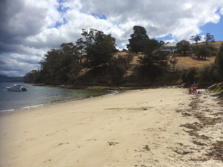
The headsail was torn, the furler broken and so on that fine day last summer I found myself down on Tinderbox Beach as the seabreeze swooped in and the tide ran out.
This beach is small and beautiful, with a jetty, yacht moorings and the great bulk of Bruny Island protecting it from the worst of the Southern Ocean’s temper tantrums.
I walked east, past children playing on the sand and adults relaxing and on to the rocks, heading for the small cobbled beach below Pierson’s Point. I hadn’t gone very far when a man stopped me.
‘What’s over there?’ he said, sweeping his hand across the northern extent of Bruny Island. ‘More of the same?’
‘Not at all!’ I said and passionately described the unique qualities of Bruny Island. ‘Not to be missed,’ I concluded.
‘More of the same,’ he said morosely. ‘I think I’ll just climb in the back of my ute and have a sleep with my little mate.’
He was well set up. He and his travel worn blue heeler had driven down from Queensland rather quickly, then crossed to Tasmania on the overnight ferry which makes port on Tasmania’s north coast. They’d then hurtled down the extent of the island to this beach at the southern end, all in one day.
Walking on beneath the cliffs, I found some beautiful rock platforms that were (at least to my untrained eye) tessellated. There are well known ones at Eaglehawk Neck but on my walks I was finding them in many more places. Soon I noticed a couple who had set themselves up in a small, sheltered corner and I stopped to ask how far it was possible to continue walking in this easterly direction.
‘Not far,’ they told me. ‘You come to a gulch that’s just too wide to jump. We’ve often thought we should bring along a plank to get over it.’
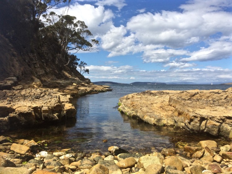
It wasn’t long before I came to that gulch. I had paused at many rock pools along the way – amongst the most beautiful I could recall seeing in Tasmania – but this gulch was exceptionally dense with beauty – kelp and a variety of other bright seaweeds. I regretted leaving my rocky shore guidebook at home because quite clearly a person should never visit a marine reserve without one.

The gulch was just too wide for me to jump. The pebble beach beneath Pierson’s Point was simply unattainable, at least today.
The other exquisite thing about the gulch was that it led into a small sedimentary sea cave. The rocks at its base and under the water had a shimmery pink glow. Right at the end of its deep resounding depths, small cobbles had been pushed up in a pile by the water, which was just deep enough to deter me and so I took a seat at the entrance of the cave and listened meditatively to what it had to say; and taped its voice.
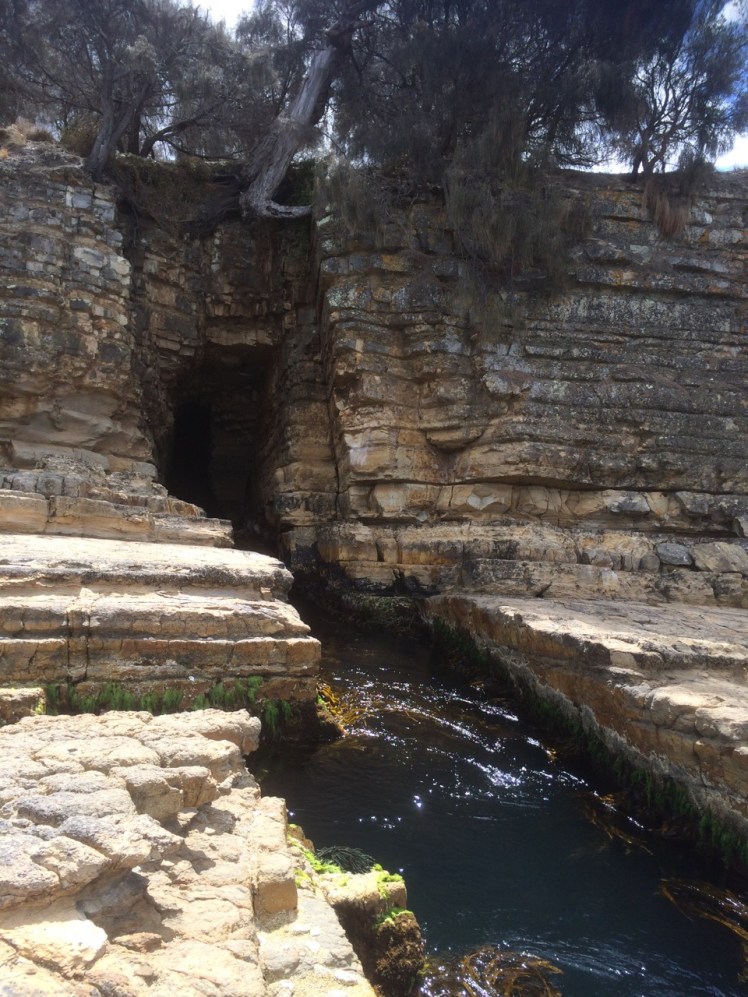
I could have sat there all afternoon, listening to that gurgling water resonate in the cave but eventually I roused myself and walked back, climbing the cliff and finding that it ended up in someone’s garden. The man who had given me directions was now alone. We discovered we had mutual friends and I told him about the places I’d been and what I’d seen along the coastline and how puzzling the paucity of nomenclature was. We were standing on Mouheener land – they’d once enjoyed the bounty of the Derwent’s western shore, the Channel and Bruny Island. He thought the Aboriginal tribes probably named significant spots on the landscape for people in much the same we so frequently name them but I shared my different perspective, that places are named in accordance with long held myths, that the landscape is redolent with story but has lost its voice and then I walked back along the rocks, wishing I’d brought a plank with me.
The blue heeler was not asleep although his big mate was. We acknowledged each other and then I crossed the beach and walked westward, bound for North West Bay.

Swimmers told me the temperature was not too bad and in fact, that summer, the waters around Tasmania experienced heatstroke, their highest temperatures ever, the East Australian current extending further south than usual and bringing with it fish from warmer climes.
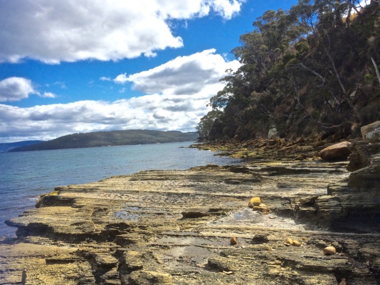
I had the rocks to myself. The sandstone cliffs were photogenic. I was able to walk almost to the point where North West Bay begins – but not quite. Still, I was satisfied to have discovered that kayaking along here was likely to be rewarding, and so after studying the ripple marks of ancient beaches etched in the surface of ancient sandstone I followed the sea breeze back into Hobart, feeling exultant.
Historic photograph of this view is at https://stors.tas.gov.au/AUTAS001124067968w800 – View of Tinder Box Bay, the northern part of D’Entrecasteaux Channel Residence of Joshua Fergusson Esq. Walter Synnot.

Makes me want to be at the beach! 🙂