Those racing days

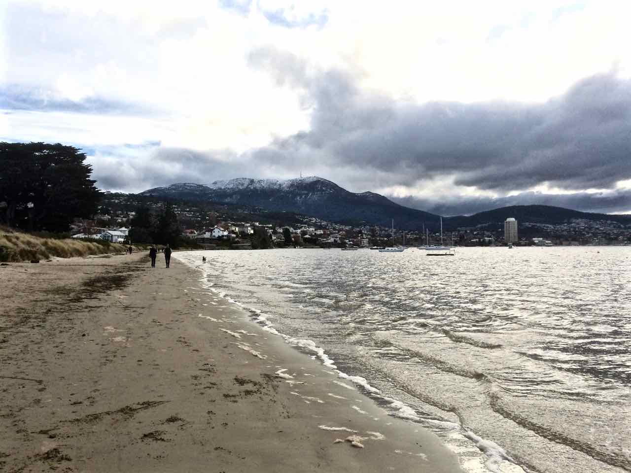
Nutgrove Beach is my wonderful ‘go to’ beach, one I mostly associate with pale sand, sunshine and activity, but because I’ve been walking through winter these photos show its moodier, more introspective personality.
I come here to think, to catch up with friends, to watch yachts racing, to enjoy the best of the day and to be walked by the dogs. The water quality is dubious but canines aren’t discouraged by that. There can be snow on the sand and they’ll still take the plunge. and some dogs, entranced by ducks bobbing on the water, and the more sight impaired by a bobbing buoy, head off in futile pursuit. Their owners cheery commands for them to return grow ever more plaintive as small crowds gather and their dogs recede into the distance. The dogs don’t stand a chance but avian business is always disrupted when people, with or without dogs come down to the beach.
Nutgrove is north/south facing, a 700 m long stretch of sand that starts at the rocky platform below the cliffs, south of Red Chapel beach. It swings slightly east and broadens out a little as it approaches Sandy Point at its southern extent. There are substantial houses – one the size of a small hotel – barricaded by pathetically small sand dunes, no more than the slightest of slopes really and at a certain spot there are no dunes at all. This beach suffered along with Short Beach because early settlers removed a large amount of sand from here too.
It’s a beach with a surprisingly fragile sense of identity. I’ve read about it and heard people refer to it as Sandy Bay Beach. In some earlier documents it also seems to have been known as Long Beach. It is longer than today’s Long Beach to its south and in earlier times when both beaches were far broader their identities were probably more fused than today. Further adding to the confusion, the Derwent Estuary Program, in a map locating monitoring sites, divides it into Nutgrove East and Nutgrove West but perhaps this is only for the purposes of checking water quality. Whatever, it can do your head in.
The Sandy Bay beaches aren’t named on the nautical chart for the Derwent River but it is identified on the Taroona 1:25,000 series. Its current name comes from a small orchard of walnut trees that used to be attached to Nutgrove House on the land behind it. The house, built in the 1880s, still exists today.
I vaguely knew the beach was there when I first came to Hobart because you can see it at certain points along Sandy Bay Road but I largely ignored it in favour of the ocean beaches. I was also understandably confused about what it was called until a friend set me straight when suggesting a group of us meet there. It was a sunny morning and the river glittered. The children paddled while we talked. For a beach of its dimensions, it was surprisingly empty that glorious day. I began to make it a regular haunt, arriving on it usually via the right of way off Sandy Bay Road, a pathway between homes that you’re unlikely to discover unless someone tells you about it – or you’re an observant walker, or you’ve parked there, perhaps to buy something delicious from Lipscombe Larder and you’ve wondered why dogs are leading their owners up or down what looks like a private driveway.
The pink historic house with the Iceberg roses, the driveway with the wooden carport, transport me to France every time and the dogs are always full of anticipation, which is catching. You walk past various flowering plants in summer and then turn to take the steps where the nasturtium grows, and there is the jetty, the splendiferous river and the moored yachts. There are the conifers we sometimes use to help us find the Nutgrove buoy when racing, and there is the beach spread out to the south. At times you feel part of a communal passagiata but it’s also possible to have the beach entirely to yourself. And you have to marvel: the land sweeps up to become the hill that is Mount Nelson, carrying the weight of Sandy Bay’s large houses, and despite suburbia that beach stretches out and you have it to yourself.
You need the tide on your side walking Nutgrove Beach. When it’s really high there’s not much space between water and dunes and you end up treading a soggy path. This is sobering. When Hobart started hankering for a race course, they decided this would be it – that it would begin south of Sandy Point and end at Nutgrove’s northern end. In 1816 that first race was run. A crowd gathered on Long Beach to watch the start but most would not have seen the horses galloping up Nutgrove. There’s no doubt many people raced in pursuit of the horses to enjoy the celebrations at the finishing line below the Beach Tavern – that very same pink building with the right of way down to the beach.
Later, as boundary fences were built and jetties split the beach up, access across private land wasn’t guaranteed and caused a lot of community friction. Fierce debate began appearing in the newspapers with various observations of increased sea level rise being used to explain the descent of fences into the river. Some writers had a fine sense of coastal processes, noting shifts in currents and the carriage of sand because of the changes being wrought in Sullivans Cove – wharfs and buildings, redirected rivulets, for instance. This was just the start of debates about private and public rights to beach access. Tasmanian Traveller has encountered this problem walking the upper reaches of the Derwent. It remains an issue in many places around Tasmania today, Battery Point being a prime example.
If you come to Nutgrove Beach from Red Chapel beach to the north there’s a smidgen of beach tucked between the rocks and the jetty-with-character (the only one remaining. This is the spot where Lipscombe Rivulet emerges encapsulated in its stormwater drain, and this ‘beachlet’ (Thanks, No Visible Means) has a sign to inform dogs that this is just for seabirds. Once, after a massive storm a few years ago, I was astonished to discover an unkempt yacht bearded with seaweed and weighed down with barnacles, sea squirts, jellyfish polyps, mussels… the whole caboodle, washed up here, a sorry sight.

Down the south end of the beach Sandy Bay Sailing Club has its clubhouse and so the beach is often full of Optimists, and an optimist you have to be to allow tiny children loose on the river in dinghies not much bigger than walnut shells. The rescue boat is always hovering. Invariably someone capsizes, a character building experience and perhaps the reason why some fine sailors have emerged from the club.
The yellow Nutgrove buoy, just off the beach, is usually the southern extent of keelboat twilight races down the western shore, so when the sea breeze is in it’s lovely to watch the fleet gybe and run wing on wing back up the river. The beach’s other nautical connection is the orange structure half way along it. This is a light that ships use to help line up their passage under the bridge.

Historical photo: View from Battery Point of Wrest Point and Sandy Point and the beaches in between.
Sources:
Derwent Estuary Program 2004. A model stormwater management plan for Hobart Regional Councils – a focus on the New Town Rivulet Catchment. Derwent Estuary Program, DPIWE, Tasmania.
Goc, N. 1997. Sandy Bay: a social history. Gentrx Publishing, Hobart.
Robertson, M. 2008. From Petal Point to Cockle Creek: a beach explorer’s guide to the East Coast of Tasmania. Regal Printing.
Short, A.D. 2006. Beaches of the Tasmanian coast and islands. Sydney University Press, Sydney.

Well written article. And I love your photographs.
Thank you!