Bay of Fires: South Taylor Beach to North Cosy Corner

Losing Our Way

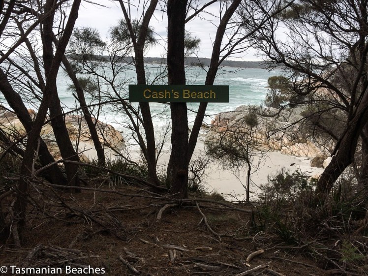
T 81 Sloop Reef Cove

DSCN0638.jpg
Sloop Reef Cove, Bay of Fires

Back at the cottage after kayaking Sloop Lagoon, I was flipping through Marianne Robertson’s book From Petal Point to Cockle Cove over a well deserved cup of tea, and discovered a beach that I hadn’t been aware of before.  Tucked away behind the big boulders at the south end of Taylor’s Beach was apparently another small cove called Sloop Reef Cove, also known as South Taylor’s Beach.

It was time to go searching – and so we went immediately.

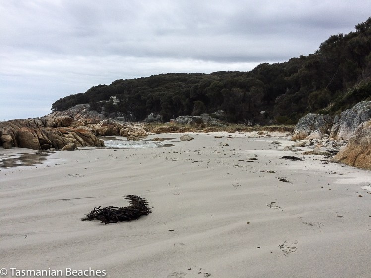
But we couldn’t find a path.  Instead, we four, two of us canines on leads, scrambled up enormous boulders and searched around when we got to the top.  Faint trails sometimes led to dead ends but we finally found a vague track that led on to a better formed path through the casuarinas and finally dropped us down to a secluded campsite where two men with a van were stoking a fire.  Down on the tiny north facing beach four people were enjoying a picnic while the surf pounded in.  It’s an intimate cove; we felt we were invading and so we sat only momentarily on the rocks discussing the undercut dune behind the beach.  The cove sloped; the surf that day rolled in and and streamed out, deflecting around the corner.  We saw the back of the waves as they raced onwards to east facing Taylors.  There is a permanent rip here.  Swimming in the cove or the southern part of Taylor’s beach looks pretty dodgy because of the criss cross waves you get here.  It was a most unsettled sea.

The boulders of Sloop Reef Cove.jpg
The boulders of Sloop Reef Cove

To Sloop Point

We knew Sloop Point well, or so we thought, but yet again, finding a trail from Sloop Reef Cove that would lead us there took a bit of effort.  We considered giving up – and considered this several times more during the course of this walk – but eventually the trail we found joined a well made contour path, which I later discovered was an old tramway track.

But why would you have a tram way here?  What sort of tram?  What was the purpose?

The walking was soft; layers of casuarina curls lay on the ground.  We passed beautiful boulders near a point with a sign that read Sloop Rock Jetty and stopped here, contemplating the dreamtime stories that would once have been associated with these powerful formations.

Granite boulder and one with indentations.jpg

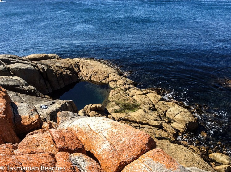
The path came out at the parking place for Sloop Point.  Four of us, plus the two canines, had come here on a warm  April day and meandered down the path to the massive sheets of lichened granite that make up the point .  It has a fantastic rockpool, deep and clear and private, suspended above the ocean and claimed that day by a travelling couple in their twenties.  This is the sort of place that’s probably seen a lot of people rip free off their clothes to skinny dip and enjoy the sun au naturale.  It’s a highly risky business as others coming after can be as surprised as those caught cavorting in this spectacular rock pool  above the sea.

Offshore were the Sloop Rocks, the bay’s most fascinating feature and visible over a vast distance.  I call the most spectacular the Sitting Buddha but it probably has many names.  I have a friend who calls it the Witch’s Hat.

Rock pool at Sloop Bay.jpg
Rock pool at Sloop Point
Sloop Rock.jpg
Sloop Rocks

T 82 Seaton Cove

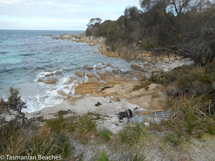
No amount of searching in the bracken revealed an onward path and so we took the dirt road down to Seaton Cove, another spot we’ve overlooked on our many visits to Bay of Fires.  It was astonishing to come to a tiny, rather suburban looking enclave in the coastal forest after wandering through the bush, sometimes on paths and sometimes not. A camper van had settled in here  (there is a little bit of camping space) but he was close by a short row of about five houses that looked like they’d lost their way to Launceston.   Like Sloop Reef Cove, this is tiny and the boat drawn up on the sand, with only one motor, must rely heavily on good weather, particularly for its return trips, because there isn’t much room for error.  It’s rocky here, both above and below the waterline and what beach there is has coarse granite sand and much kelp strewn about.  I found some sea glass and a beautiful quartz pebble well polished by the sea.

Seaton Cove South.jpg

But a well defined path led on past the bottom of the gardens, following the fence line, and back into the peaceful casuarina forest.  Again the path grew uncertain.  We’d lose the trail then find it again.  Finally we found ourselves in a patch of sand surrounded by boulders and apparently isolated from the sea.  Even here, so close to the sea, frogs serenaded near the small soaks in the rocks.

We had been walking along the top of these massive sloping granite platforms and boulders for some 500 m but they were getting to look familiar.  Sure enough, we soon saw people on top of the huge boulders we know well – we’d made it to Cosy Corner.

Approaching Cosy Corner (n) on the rocks.jpg

We lingered here, feeling triumphant and wondering whether to head for the main road.  It was getting on for 4 pm.  This seemed an unadventurous option and so we turned around and walked back across boulders and through the bush to Seaton Cove.  I was surprised on this visit to notice the beach was longer than I’d thought before, rocks dividing the cove into a north (hidden from the road in) and south side.

Bay of Fires Seaton Cove
Looking south over north Seaton beach.


Again we debated resorting to the road we’d walked down before but there was a clear path we could see now, heading around the northern side of the cove at quite a height above the shoreline.  We followed it, but it let us down and we got lost in bracken and fallen trees, just pleased it wasn’t snake weather.  We could see the tree line along Sloop Point and so we clambered down on to the boulders then bushbashed up the other side when a gulch seemed impassable.  Our trusty path finder took the lead.  She invariably chose a route better than the ones we selected but she’s  getting on and occasionally needed a helping hand over the trickier fallen logs.

This time our choice was clear – buoyed by our progress, we took the beautiful contour path we’d walked before.  We reached a dirt road descending to Sloop Reef Cove but noticed the path continued across the road, above a few houses nestled in the southern corner of Taylors Beach.  Orchids grew along here, pale purple and unassuming.  It wasn’t long before we met the Gardens Road just above Taylors Beach and Sloop Lagoon.

This is the kind of walk I find the most exhilarating – a walk where the way is unknown and sometimes hides itself, demanding a degree of perseverance to continue, but offering up surprises – like another of those branch shelters that we’ve seen at Tinderbox, Dora Point and a few places elsewhere.

This slideshow requires JavaScript.


North East Tasmania: Bay of Fires: Humbug Point Nature Reserve: Boat Harbour Cove to Dora Point

Puzzling Over Humbug Point

Closing in on Grants Point
Humbug Point Recreation Area.  Grants Point (left).

Map and further info about  Humbug Point Nature Reserve

The holiday homes of Binalong Bay spread up the northern slope of Humbug Hill, but behind them the original vegetation remains considerably intact, protected inside the Humbug Point Nature Recreation Area.  This reserve spreads across both Humbug and Bald Hills.  It’s mainly dry sclerophyll forest (although it has its boggy bits) with a diversity of plant, wildlife and bird species and a spectacular coastline that makes for a wonderful walk.  There are various free camping spots that have a more enclosed, bushland feel than the coastal camping sites along the road to The Gardens, north of Binalong Bay, and until our last visit, we had relied more on our car than our feet to take us exploring in this area.

I wondered how this area got it’s current name, given that in northern Australia ‘humbug’ is an Aboriginal term for placing unreasonable demands on family, but according to the Tasmanian Nomenclature Board, it’s first shown on an early diagram (1/386 Dorset) as Point Puzzle. They say it was named by a certain  J. H. Wedge, because of the frustrating difficulties experienced in running stock there. Thylacines took his sheep and lambs, apparently, so perhaps farming there was in fact humbug as far as his family was concerned.  They themselves were bigger humbug by far for those families, bands and tribes who had lived more lightly and longer  on this particular country.

The board also notes Top Bay (AMG608 x 5426), which I hadn’t spotted on any maps, as one of the small features west of Humbug Point (as advised by Jack Mallinson and Alf Barnett of Binalong Bay, January 1977).  Possibly this is the spot where we found an unexpected beach.

***

We made an impulsive decision one Monday lunch time to head north.   We threw some clothes into a bag, bundled the dogs into the car and headed up to the Bay of Fires for a couple of days of down time.  Our first walk was going to be to Dora Point and back to Binalong Bay along the Skeleton Bay Track, but in the end we did it over two walks.  One of us was sick on our first attempt and we also failed to take enough water for our canine companions.  For September, it was surprisingly hot although for most of this walk the weather was overcast, going by my photos.

Binalong Bay Coves

We lingered in the Binalong Bay coves just to the south of  Boat Harbour Cove / Binalong Gulch.  The sand was still free of footprints and it was all so idyllic. It was the kind of morning for snorkelling, for settling in comfortably with small children still excited by the prospect of sand castles, for putting up a beach umbrella and losing oneself in a book.  We observed the lichen’s low level mark – perfectly straight – and the pelicans near the boat ramp.  I imagined these coves long ago, small campfires burning, Larapuna bands hunting through the scrub and diving for shellfish in the translucent waters of the bay.  The gulches make perfect pools for those who like to keep their feet grounded.  The boulders never cease to fascinate.  You can lose yourself in the view north for hours and while there are pockets of sand in the gulches that one could kindly call ‘covelets’, there is in fact a high tide, white sand beach with lovely boulders and tidal pools, about 100m wide, according to Andrew Short (2006), who  numbers it beach T90.

Binalong the coves
Down amongst the gulches of Binalong Bay

T91 Skeleton Bay (or South and North Skeleton Coves)

Skeleton Bay.jpg

There’d been a full moon by night and all day a big swell had been flowing into the bay, with a huge surf crashing against the points visible to the north from our cottage on the hill, but the water in the coves was comparatively gentle. Eventually we left Binalong Bay, walking around the corner into wild and much smaller Skeleton Bay, the real start of the walk.  It has two coves, North and South, with small Skeleton Rivulet feeding fresh water into the sea after rain falls.   There was a ‘don’t mess with me’ surf smashing in here too; water in a hurry.  Kelp lay strewn along the wrack line, big pieces, their feet intact, testifying to the strength of a past storm, and I started to pick my way over the coarse, white sand while the geo stuck to the road above. Almost immediately I found myself walking into a cloud of the small, flying invertebrates usually attracted to rotting seaweed and the pungent treasure that contains.  I fled their avid interest by escaping through the bush back up to the road.  The walk could only get better.

We crossed the rivulet and began the walk to Skeleton Point and, just offshore,  walk- stopping Skeleton Rock. The meandering track follows the coastline with beautiful views its entire length and I had the strong sense of this being, under the thin disguise of a modern path, a Larapuna track, whole eras old. Granite underpins the vegetation, she-oaks extend behind the boulders and the path is densely covered in their curls  when walking through copses. Boobiala and kunzia were in flower.  Every so often paths lead down to places where wonderful views give way to the spectacular. That day there were two other parties of walkers enjoying the track, and we met both in the vicinity of Skeleton Point, but we seemed to be the only ones intent on walking through to Dora Point, about 4 hours return.

The day became overcast after that bright sunny start but each time sunshine burst through, we sweltered and kept a sharper look out for snakes.

Grants Point

We reached Grants Point. Offshore to the south are Grants Point Rocks.

Grants Point rocks.jpg
Grants Point Rocks: there’s surely a myth attached

In this vicinity the path is on a higher contour and after passing  boulders with big auras all gathered in an area backing the point, there’s a truly massive one with a particularly looming, mysterious presence.   This rock definitely has to have a dreamtime significance but it’s meaning and name are lost in time, unless perhaps you’re Larapuna, and if it has a modern one that’s hard to track down too.    It seemed reasonable to suppose that the day use/camping area close by might once have been a place of significance to the original inhabitants who lived in communication with this land.

Boulder at Grants Point.jpg
Base of the large boulder at Grants Point, Humbug Point Reserve

We stopped here for a while, enjoying the view and the ambience created by the boulders, then contemplated the wisdom of going on. I felt both relief and failure when we turned around.  This time I was determined to walk the full extent of Skeleton Cove but again we were assailed by insects and fled off it in a rush, through yet another band of insects, this time mosquitoes.

***


Dora Point Beaches (T92, 93, and one unidentified)

Take Two began at the other end of this walk, on Dora Point Beach (T93), just within the northern headland of Kunarra Koona (Georges Bay) and huge breakers were rolling in over the sand bar. I turned sailor, not liking what I saw, and we had a long strategising conversation as we walked to the start of the track, about bars and stormy weather, crossing sandbars at slack water and the history here of dredging and the current breakwater developments we could see taking place at the far end of the beach.  Once, when we were being hammered by a ferocious northerly gale just south of here, both yacht and crew compromised, seeking refuge in Georges Bay had been considered. I’m glad the skipper quickly dismissed this option.

This is also the kind of beach to enjoy from an aesthetic point of view and if you’re a fisher it’s a good place to cast a line, given the piscean through-traffic. But leave your bathers at home. A big body of water enters and departs through a narrowe entrance and the current isn’t to be taken lightly, although that’s how it would surely take you. This great lagoon spreads inland to St Helen’s. The sandbar gets dredged to keep the mouth open and there’s a breakwater that’s led to a  beach blossoming on the southern side of the entrance.

Dora Beach is quite a wide, curvaceous beach with soft white sand and seawater pooled that day in the hollows the outgoing tide had left behind. It’s especially beautiful as you walk north across it to the start of the track. A density of ti tree forest creates an intimate feeling in that corner of the beach, well protected from northerly winds out of both quarters, but I felt it was keeping secrets and when we reached the track we saw it hid a shelter, made from fallen branches, beneath its canopy.  These are surprisingly common on coastal bush walks.

Dora Beach.jpg
Dora Point Beach (T 93): pausing to read the ripple lines

We started on the path and rounded the headland and it was not long before we reached a beach divided by an outcrop of boulders into a northern and southern half. Someone had put a sign saying Cash’s Beach above it; a new sign.  (I think it’s T92, Dora Point North in Short’s inventory)  We wondered at its significance and later, talking to a local beach afficiando who knows this area extremely well, his bemusement was much the same as ours.

Cash's Beach.jpg

We took a relaxing stroll through casurina forest on a beautiful track, at times through  muddy puddles and ti tree groves, and over a small marsupial meadow, scats in abundance and small tunnels in the undergrowth, the boom of the surf and the serenading frogs, so tolerant of the ocean that they also sung from puddles  in the granite boulders, where, on closer inspection, we saw tadpoles and mosquito larvae.

We crossed a little meadow.  We walked through boobiala thickets.  The vegetation ranged from dry loving plants to thirsty plants. There was sometimes moss growing on the granite and lichens on branches, and it was an easy, thoroughly satisfying walk, no significant ups and downs. We passed Grants Rocks, we passed a beacon and we came again to the boulder at Grants Point, where again we sat for a while, gazing out to sea, trying to decipher the memory of the big boulders behind us that we’d past the previous day. It was a Wednesday. There was no one else on the track.

Beach2 on Dora - Grants walks.jpg
Isolated  beach, Humbug Point Reserve

Our return walk held two surprises apart from the usual one of the return walk always seeming so much shorter. The geo spotted two more beaches, small and tucked away, difficult to see from the path if you weren’t especially looking and when I checked Short I was satisfied that we had again discovered a beach that was not on the inventory.  The last one we found was Dora Point (T93), which we’d passed without noticing on our way north.  I spied a pair of pied oyster catchers on it and a white buoy that had drifted up on the tide. I carefully snuck down and claimed it for Samos, the pied oyster catchers so intent on foraging that they were none the wiser to my presence, a bit of a coup on an island where the birds are usually jittery.