Tasmania’s North East Beaches: Bay of Fires: Sloop Lagoon by Kayak

Sloop Lagoon by Kayak

Of Swans and Leaches


Sloop Lagoon seen from the rocks above Sloop Reef Cove over Taylors Beach
Sloop Lagoon viewed from above Sloop Lagoon Cove

 22 Sept 2016

It was almost impossible to squeeze into my wetsuit. It slowly dawned on me that it wasn’t mine at all but an old one belonging to my daughter. Kayaking in a teeny size 8 would feel like I’d been swallowed by a snake and so I wore it legs up only, and layered thermals  over that.

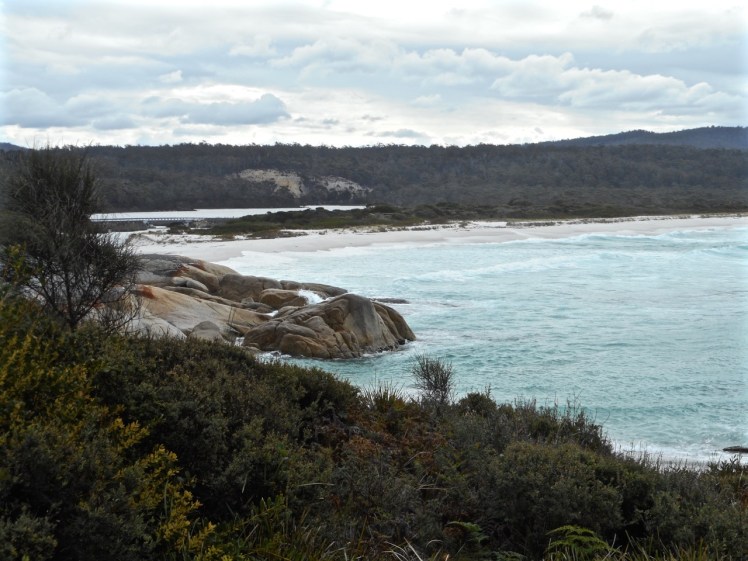
I had decided to kayak around the circumference of one of the dune trapped lagoons along The Gardens Road and decided in favour of Sloop. The morning was overcast and there was a little bit of breeze by the time we reached the lagoon, somewhat later than planned.  I felt a little mournful, as I always do, when the breeze is fooling with the surface tension, marring the glassy water I like so much when kayaking.

The geo helped me launch and our one dog followed, peeping unhappily. She’s the pack leader and path finder. She likes to keep us together and on off lead areas will always come back to collect me if I’ve lingered behind.

I was aiming for the bridge that goes beneath the Gardens Road and paddled swiftly across the tannin water, eventually dropping her. On the other side I found a narrow channel, closed off at its mouth. This lagoon was saline and sometimes black beneath the clouds.

DSCN0602.jpg

I idled here.  Frogs were being vocal in the rushes, a surprise to hear them in such a salty environment and I wondered if the many flood events this year had altered the salinity level.  The surf boomed on Taylor Beach. It was peaceful floating and listening to the soundscape.  I drifted down to where the lagoon meets the beach.

dscn0603

And then I turned around, headed back beneath the bridge and set off to circumnavigate this dune trapped lake.

DSCN0606.jpg

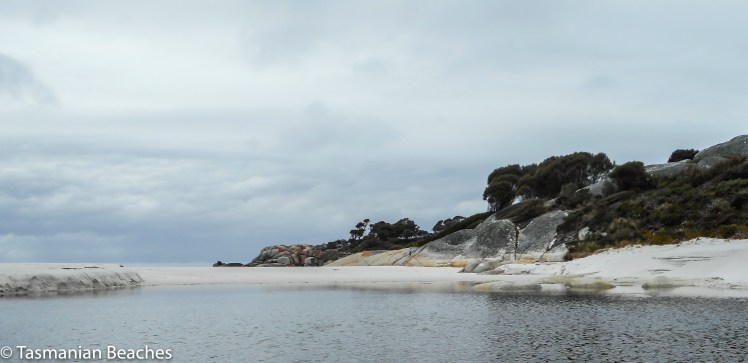
It’s a quiet world in amongst the boobiala, rushes and ti tree.  As I kayaked around the edge of the lagoon I spotted two swans’ nests in the reeds but there were four couples in total that came gliding out from among them at various points and moved away from me, honking small warnings.   In fact, despite my best attempts to be non-intrusive, one took off heavily in front of me, half running across the water – we had not seen each other until the last moment.

I’d last seen black swans on the Thames, near Kensington Palace.  That was a surprise too, but apparently a small number have acclimatised there.  Far better to see them in a habitat that’s natural to them.  They’re migratory, but their pattern of migrating is opportunistic and erratic and they plan their travels according to what the weather’s been serving up.  The oddest swan behaviour I ever saw was one that flew over to a bay and paddled out to sea.

Don’t believe those stories of them being loyal to one partner for life.  They’ve been found out.  Swans cheat; sneaky affairs take place in hidden corners of the rushes and so watching these partnered birds gather in the middle of the lagoon, I wondered about the layers of their relationships and whose eggs were whose in those nests in the shallows.  I didn’t check the lagoon’s depth, but swans like shallow water so that they can bottom feed without diving, one way to tell.

Down at the far end, near the quarry, I found a small stream and seeking out the glassy patches where I’d be more protected from the south easterly, I found a crane staring attentively into the water.  There were also full throated frogs around the lake from time to time, and small lunettes that doubtless hold evidence of camping and feasts from the eras before colonisation.

DSCN0616.jpg

The lagoon held one final surprise for me.  This is what we saw when we went to load the kayak – a huge leach with a foot that could have competed with kelp for grip.  A leach so huge it could suck a swan dry.

DSCN0629.jpg


North East Tasmania: Bay of Fires ~ Binalong Bay

Binalong Bay ~ To Where we Keep Returning

View of Binalong Bay from Cosy Corner
View of Binalong Bay and Humbug Hill

The Bay of Fires from Humbug Point northwards is an exhilarating stretch of Tasmanian coastline.  There’s just something about the white sand, the lichened granite boulders and the crystal clear water that combine to make it particularly awesome and peaceful at the same time.  In summer, when it’s warm, the bush camping along The Gardens Road is the loveliest we’ve found in the state and in the cooler months there are plenty of beach houses available for hire.

Binalong is a small settlement on the northern slope of Humbug Hill, backed by a great reserve and with wonderful views.  It has a tiny permanent population of about 200 people and is a mix of small shacks, large mansions and modest beach houses.  There is no shop but there is a small cafe with a good menu and expansive views.   Behind the bay  and at the foot of  the hill  lies Grants Lagoon, wonderful for birdwatching or kayaking.

The complexity of the landscape – the casuarina forests, the photogenic rock formations and the dune trapped lagoons combine with the beaches to make this area totally compelling.  Apart from cycling, swimming and kayaking, there’s a surf break at the northern end of Binalong Beach and at the southern end there are a number of beautiful coves separated from each other by massive boulders.  There’s a gulch that forms a tiny harbour of sorts and these days  an ecotour leaves from here and heads out by boat along the coastline as far north as Eddystone Lighthouse.

Harbour at Binalong Bay

This spot hasn’t always been called Binalong Bay.  It was once Boat Harbour but as there is also a Boat Harbour in the North West, it cast off name confusion and opted for something more indigenous.  The Bay of Fires was known as Larapuna by the  people these days known as the North East nation. There are believed to have been seven clans in all (Johnson & Mcfarlane, 2015) , roughly totalling about 500 people* who willingly granted seasonal access to the Ben Lomond nation, probably for reciprocal rights, enabling them to benefit from the area’s rich pickings.  It was a meeting place and as the climate was mild, it could well have been where most Tasmanians chose to live in earlier periods of the Holocene.

The current name of the Bay of Fires was provided by Tobias Furneaux, who captained the HMS Adventure (part of Cook’s Great Antarctic Expedition of 1772-1775).  He and his expeditioners noticed many campfires burning in this area at night, and aboriginal stone formations, seal traps, burial sites and middens still exist, so treading lightly and respectfully needs to go hand in hand with leisure and enjoyment when visiting this area.

After the European invasion, sheep farming, fishing, forestry and the transporting of these commodities grew in importance and on our last visit we discovered the tracks of what had once been a local railway.  It follows a contour, then ends at the gulch, where today there’s a jetty and boat ramp.

We’ve been to the Bay of Fires three times this year.  First we camped and then we brought some of our overseas family here.  The mad keen cyclist promptly headed for the Blue Tiers track while the rest of us, being of more idle dispositions, merely rode from Binalong to the The Gardens, did a bit of Humbug Point exploring and had a pleasant amble along Binalong Bay Beach, the white sand soft underfoot.

It was only when we were at the farthest end of the beach where the big boulders begin, that we realised the cyclist had taken both sets of car keys.  He was expecting us to meet him in Derby later on that particular day but his mobile had no Australian reception, so while he  waited and wondered what had happened to us, we tried to relax into the knowledge that there was nowhere to go and nothing we could do except soak up the sun and admire the sublime view from the beach house.

The geo and I came back again shortly after our Hong Kong to London train trip.  This time we focused on exploring with a little bit of kayaking thrown in for good measure.  We met a local artist and had some long chats with a new friend who is walking the beaches from the Tamar to Freycinet.

Binalong Bay beach is a  poignant beach for me.  A good friend, who loved this spot too, had a heart attack on an early morning stroll along the sand and although he recovered, did not see out the year, dying on my birthday.

Binalong the coves

*Given the fact that European invasion of Tasmania caused numbers to collapse quickly and dramatically, this number is a best guess by some of those working in the field.

References:

Johnson, M & I. McFarlane. 2015.  Van Diemen’s Land: an aboriginal history, UNSW Press, Sydney.


Frederick Henry Bay: Pittwater Nature Reserve: Penna Beach

Touching the Land of the Moomairremener Band

Map of Pittwater

Penna Beach

When you fly into Hobart’s airport, peninsulas of land and bodies of water spread out below.   One of these watery stretches is the large, relatively shallow estuary/lagoon that forms Pitt Water Nature Reserve and Orielton Lagoon (east, and just off this map).  The Coal River, Penna and Iron Creek pour freshwater into it.

This striking body of water is  crossed by McGees Bridge and the Sorell causeway, both tethered to a suburbanised headland in the middle of the lagoon called Midway Point. It enters the sea between Seven Mile Beach spit and Lewisham.

I love the view coming in to land, love crossing the causeways, the seagulls hanging in the sky, the salt spray… but it’s not an area that I’ve ever explored.  I last flew over it a few weeks ago, returning from a postponed yacht delivery in Queensland.  This time I went to the map to find out more about it.  The names of the places surrounding Pitt Water intrigued me – Shark Point Road, Penna and Frogmore Creek.  It was clearly time to go adventuring in the lands of the Oyster Bay and Big River tribes.  The Moomairremener band in particular, spent a lot of time around Pitt Water.  Their presence is there in the middens and quarries they left behind.

At Midway Point we turned right along Penna Road and quickly found ourselves in countryside with the water to our left. Then we turned left along Shark Point Road.

This road runs along the northern shore.  There’s a row of houses, some beautiful, others not, but if you don’t mind the sight of traffic crossing the causeway in the distance, then the northern shore is a secret gem.    The dirt road takes a corner and heads north, up into farmland, home to Highland cattle.

Shark Point Road, it turns out, gets its name because this estuary is much loved by sharks, including the gummy shark.  They come here to forage and to breed.  It’s the nursery for their babies and while they’re unlikely to nibble a kayak I may put on hold indefinitely my plan to paddle its perimetre.  In recognition of its importance to the sharks it was declared their refuge and no-take area in 1995.  There has to be something in this for people, right? These sharks are fished commercially.

We turned around and sought out Penna Beach on this northern shore and found that it’s in a part reserve, part dog exercise zone.  We walked down to it through tussocks and an astonishing diversity of weeds, including box thorn and boneseed.

White shells clad much of the beach and they’re there again in the soil profile behind the beach, along with a thin trail of pebbles denoting an earlier landscape.   We figured this is the same shell layer that is visible at Ralph’s Bay, that beautiful embayment on the Derwent River.  Strolling along its full, extremely skinny extent we also noticed that the rising sea had nibbled into the soils behind the beach so that only the roots of the tussocks and a depth of about about 10 cm of loam defended the land from the fluid invader gaining might millimeter by millimetre.

As we walked along we discovered some lovely  little salt marshes and wetlands behind the beach, although some had an algal infestation.  We didn’t see the little blue butterfly that forages here but we heard some brief birdsong emerging from the tussocks.  I thought the area could have provided a wonderful habitat for nesting birds but I suspect there’s far too much human disturbance for them to make a go of it. It was only later that I discovered that this area is renowned for its salt marsh diversity and rare plant species.

 With an oyster farm tucked into a corner of Pitt Water at Barilla Bay, as well as at Woody Island and Shark Point, along with other human encroachment, such as homes and causeways, water quality has taken a battering.  At least forty different types of fish, including eels, seahorses, pipefish, sharks and rays have been known to glide beneath the surface, some enjoying the seagrass once prolific in the quiet shallows.
There’s a man who, between 1975 and 1995, came to know this area, it’s plants and animals well. Geoff Prestige watched as the banded stingaree, southern conger eel, shot-headed eel, rock ling, pipefish, soldier fish, rock flathead, king barracouta, weedfish and smooth toadfish, once prolific, became rare or vanished completely.   He also observed snails and worms and molluscs, along with other invertebrates quietly vanish.

Once at least seven types of migratory birds flew here from Alaska to enjoy Tasmania’s summer.  This estuary, since 1982, has been a RAMSAR site – in fact, the southernmost site on the East Australasian Flyway but given our interconnected world and development across both hemispheres, this hasn’t stopped numbers plummeting like a distressed stockmarket.

One little known fact about Pitt Water is that it is the home of a tiny, rare  orange seastar (Parvulastra vivipara), one of very few anywhere that gives birth to live young.

People like to fish on the seaward side of McGees Bridge and they like to bird watch at Sorell Causeway and the Waterview Sanctuary.   Levees have messed with the tides that supported Pittwater although there’s a bit more flushing happening these days. Farmers have spread fertiliser on their fields, fostering algal growth in the lagoons.  Dams on the Coal River have stymied freshwater flow.  Seagrass has withered.

This area really symbolises the way we are hammering the lovely world but here’s a small plus.  On all the slender extent of Penna Beach I only found two pieces of plastic litter, and I thought that a small solace.


Sources:  Pitt Water and Orielton Lagoon Ramsar site and in particular, the NRM South Report to the Community (2012)  


Penna Beach

Penna Beach tussocks and pigface

Wetland behind the beach

Tussocks and erosion