Derwent River: Blinking Billy to Hinsby Beach – Part 1

The Word From the Foredeck

I’ve had lots of opportunities to observe the coastline between Blinking Billy Point and the Alum Cliffs. It’s a scenic kayak trip from Short Beach to Kingston and when there’s barely a ripple on the water it’s lovely to idle in time and on tide and simply float a while, mind empty, just lost in the beauty of the estuary and its shoreline. A cormorant dives, a fish jumps and occasionally a beetle on its back, its legs flailing disconsolately, might require rescuing.

The breeze is my friend if I’m sailing but I’m less keen on it when I’m bashing into white caps when kayaking – although surfing waves with a  following wind (always more gentle) is a lot of fun. The Derwent’s water is cold and I know my limitations; it would snap freeze me if I fell in and hopping back into a sea kayak after a capsize is not easy at all. When the wind strengthens I’m ready to head for the closest beach. My focus contracts to the wind and the waves and the shoreline barely gets a second glance.

BlogCover

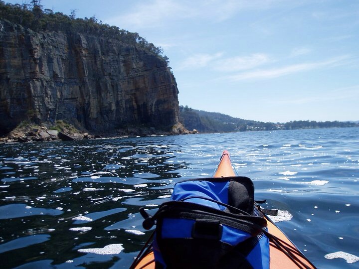
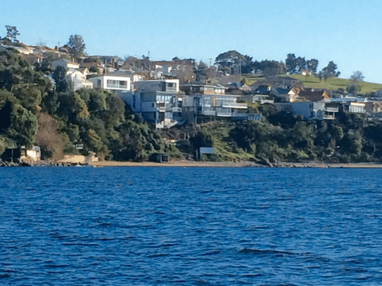
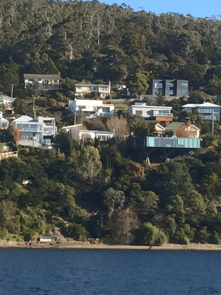
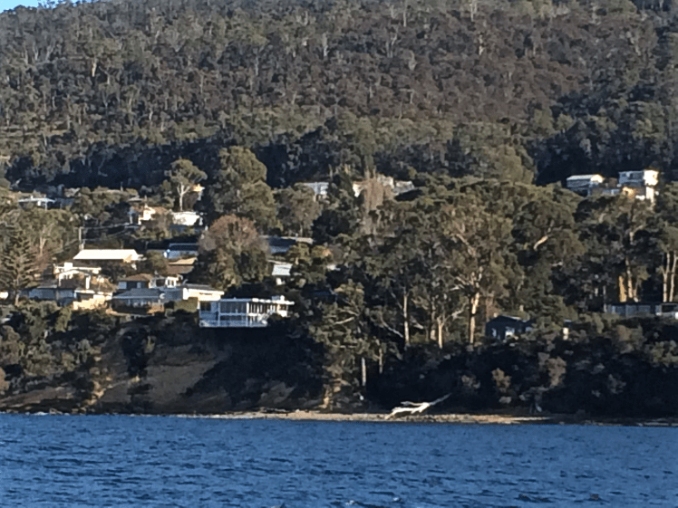
The landmarks I pick as waypoints when I’m sailing or kayaking are known features and this is what I was remarking on to my friend as we sailed home one day after a weekend down the channel. The skipper wasn’t calling for a sail change. The mains’l didn’t need tweaking and so we were chatting about the Taroona-Sandy Bay coastline we were sailing past. There were the cliffs topped by houses. There was an occasional set of steps, a sundeck or a boatshed but mostly it was sombre rock and remnant forest higher up and I couldn’t have named any spots along there. My friend didn’t exactly agree with me about the shoreline’s inaccessibility though.

‘It’s not really,’ she said. ‘If the tide is right you can walk it. In fact, you should. It’s worth it.’

IMG_3522

‘You should, it’s worth it,’ I was to discover, was an enormous understatement but for a long time I did nothing with this information. It was only once I’d decided to write this blog and to include the river that I acted.

IMG_3533

I went to Taroona and I explored the roads closest to the shore looking for access points to the river. I’d like to say I studied the chart and the maps but I didn’t. I looked at them in the most cursory fashion and they never made it into my backpack. But one Friday night before going to bed I did pick up the tide table. I wanted the moon and sun to be in alignment for a very low tide – ideally a Proxigean spring tide. There would be supermoons in August and September but this was June and I didn’t want to wait that long. Hobart doesn’t have a big tidal range – the maximum is 1.32m but on a narrow, rocky coastline that’s still significant.

IMG_3528

To see what the tides might be on any particular day  I’ve always done it the easy way – just clicked on the tide app on my phone and so I wasn’t too sure I was interpreting the paper tide table across the year correctly, particularly as it seemed to me that the next day looked like it would be pretty damned good regardless of the lack of a spring tide. It was June and actually, it was quite close to the winter solstice. If I’d known more about beaches at the time I would have known that winter isn’t actually the best time to find the beaches all stretched out but at that point I hadn’t encountered Lena Lencek and she had a few things to tell me that the geologist had not.

IMG_3546

And so I set the alarm for Very Early, pretty excited about this walk. It was either going to be stunning or it was going to end with me against a cliff, the dark water rising.

Derwent River: Marieville Esplanade (South)

Still Just Hanging In

Sometimes you just don’t see what’s in front of your eyes.

The cardboard sign at the start of the track gave me pause for thought ‘Snake Spotted Lying on the Path’ someone had written, and so instead of exploring new territory I headed down to the marina to do a bit of work on Samos. The dogs lay and watched me.  It’s currently the summer solstice, the day was hot, the moon  a waxing gibbous and the tide  low but oblivious to all this I was tending the engine and talking to my neighbour.

At a certain point I looked past the yachts and ducks to the houses that occupy the foreshore.

There at their base were remnants of beach.  Rather sorry looking remnants but large enough patches of  polluted sand to provide private coves for those lucky enough to live in those houses.  Not that long ago it was a longer stretch of cleaner sand and boats swung at their moorings in the lee of Wrest Point.  Now the marina’s been extended and there are new floating berths.

This view has become so familiar to me but in failing to question it I hadn’t seen it for what it really was: a beach still present enough to make a statement:  well may I go unnoticed but I’ll be back in one guise or another long after the marina and these activities are gone.

Beach at the DSS

Beach remnantsDSS Beach remnants

Derwent River: Blinking Billy Point

The Geography of Nervous Twitches

There’s a concrete path that curves around the southern edge of Long Beach and leads out past Blinking Billy Point to Blinking Billy Beach. When the South Westerly is churning up white caps on the river this path is sheltered and has a great view north across Long Beach and down to the bridge but once you step from the behind the shelter of the hill the wind is out to get you and its Antarctic breath can cause your eyes to stream.

Blinking Billy Path
The narrow way

Conversely, when the tide is high and waves are being hurried into the bay by an exuberant North Easterly, you may find yourself attacked by an encroaching wave and forced to turn back. Mostly, though, it’s a sunny light hearted sort of stroll, long enough to sniff the breeze but too short to regard as exercise.

Looking north on the walk to Blinking Billy Point
The view north on the path to Blinking Billy Point

A friend had told me there was a Sandy Bay beach where dogs were welcome any time of day but her description was vague and I had struggled to find it. Then one day, coming back up river after a weekend of sailing in the D’Entrecasteaux Channel I noticed two labradors with their people on a stretch of sand I hadn’t paid attention to before, and recognition dawned. It’s now become a favourite walk when the dogs are keen to go adventuring and I can’t quite match their enthusiasm, or I want to catch up with a friend for a coffee and treat them too.

As with most of this coast, Blinking Billy Point has changed names like people change clothes. It used to be called One Tree Point until (I’m supposing) that lone tree was no more. It was also once called Garth’s Point.

The Garth’s came here from Norfolk Island with seven children in tow and made a quick segue from the merest of shelters to owners of two land grants, the one encompassing the point and the land uphill through what’s now the Alexander Battery Reserve, and the other spread across Porter Hill.

The Garth’s were farmers by day and smugglers by night. The submerged reef below the point was called Garth’s Bank and served two purposes: fishing and smugglers’ lookout. Further uphill on their smaller Porter Hill grant, they built their smugglers’  hut and it lasted until a fire burned it down in 1978. Devon and Cornwall can move over, I think, because Tassie has a rich smuggling history too.

One fine day when we were idling past the point on a light breeze someone mentioned that long ago William Watchorn, harbour master, a man with nervous eyes, lived on the point. He lobbied for a light and he got it. Both the point and the light assumed his nickname: Blinking Billy. The light still stands and while its gaze was fixed and unblinking in its time, it works no longer and is disregarded by river traffic.

This light was rendered useless by the John Garrow Light, a navigational structure, cormorant hang out and sometime racing mark, that took its place offshore on Garth reef. For some obscure reason this light is named after a pastry chef who lived in Bath Street (Battery Point) and the pastry chef’s name was extended to Garth reef as well. It’s now known as the John Garrow shoal.

Blinking Billy Light
John Garrow Light
John Garrow Light

For a low, unassuming point, Blinking Billy Point carries a wealth of history and interesting buildings. Along with the navigation light there is the remains of the searchlight emplacement. Two spotlights, precursors to the Dark Mofo lights, but focussed on defence not entertainment, lit up the sky from 1890 to WWII, playing their role as part of the the Derwent Defence Network, which included, in this vicinity, the Alexandra Battery further up the hill and the artillery at Fort Nelson.

Searchlight
Old spotlight emplacement

There’s also an old part of the city’s sewage system – a small blue pumphouse which was built in 1919 and is deceptively pretty.

Pumphouse for blog
The pump house

People still cast a line over the smugglers’ reef on fine days, but those of us who sail know only too well the river’s violent mood swings and I’ve seen kayakers caught out here, just metres off the pointt, overturned and struggling to reach the shore.

Sources:

Nautical News: the newsletter of the Maritime Museum Association of Tasmania. Winter edition, 2002.

Goc, N. 1997. Sandy Bay: a social history, Gentrx Publishing, Hobart.


Derwent River: Rivulets: Meeting Wayne

Had I been more attuned to the landscape, I might have immediately realized that this city was criss-crossed with rivulets but it was only after leafing through a report about Wayne Rivulet back in 2003 that I began to observe the landscape more carefully (or so I thought) and recognised that if we valued natural landscapes more highly Hobart could have been an even more beautiful city.

One rainy Saturday that year, the report in my hand, three of us went in search of Wayne. We drove through Sandy Bay paying attention to the dips and hollows where rivulets once might have flowed and we went to Long Beach to seek Wayne’s mouth because I’d read that according to Wooraddy – or so George Robinson said in his journal – there used to be a large Aboriginal village there. And if this was true then a rivulet would be a most necessary resource. I discussed the possibility of a  village with an archaeologist I knew and he wasn’t too sure he trusted Robinson on this issue and let’s face it, a language barrier can lead to a lot of misinformation.  Elsewhere in the literature it’s considered to have been a camping site.

In 2003 the beach was disappearing so fast that efforts were being made to shore it up. We stood on this little remnant of beach and figured out that the rivulet emerged where new works were happening at the southern end, and then I noticed that we’d actually parked right above the stormwater drain, which is now the mouth of Wayne Creek.

After a little exploring around the area we found the rivulet again higher up the slope at Fahan School. A sign testified to their care of the rivulet and how they used it for educative purposes but it looked crestfallen that day and damaged by diversion. It flowed over watercress and then into a more established looking bed below the willow trees and under a little wooden bridge. Its bed grew deeper and cut around the edge of a small shed, ran under the road, emerged again just briefly then disappeared completely until it reached the end of the pipe at Long Beach.

A scientist friend who knew about Wayne said it was corroding the diesel tank under the BP petrol station (now United) and so that spot is on the contaminated sites register. I asked a Fahan student if she knew where Wayne Rivulet was and she said she’d never heard of it.  When I told here where she could find it, she said, ‘we just call it ‘the creek’ but after our conversation she went looking and told me about the signs in the playground. ‘So I probably did know,’ she reasoned.

We climbed up behind the school and tried to track Wayne to its source higher up Mount Nelson. We figured it had to be near a large purple house on the upper slopes but in fact, although two tributaries are said to flow into Wayne, we had no luck finding any trace of any rivulet above Churchill Avenue. There were new houses encroaching into the bush up there and they impeded our search.

It’s now 2015 and Wayne Rivulet remains largely unknown to Hobartians, but that’s also true of the other disregarded rivulets, most being unassuming, sporadic and unknown. Today I went back to take a peek at Wayne and I was disappointed to see that it looked as crestfallen as ever.

Wayne Rivulet 1
Wayne Rivulet 2015

Not that long ago a friend and I did a walk from the mouth of Lambert Rivulet at the Derwent Sailing Squadron, up the shady gulley to the top of Mount Nelson and down through the Truganini Reserve to Cartwright Creek in Taroona. Lambert enjoys a lot of daylight and makes its way through a densely foliaged linear reserve. It’s the lucky one, along with a tiny handful of others.

Hobart Rivulet
A natural stretch along the Hobart Rivulet: how our creeks should look

Chatting as we walked, we wandered across the catchments of the other Sandy Bay Rivulets that these days are sealed up tight until they get to the river, but there was so little evidence of their presence that lost in conversation and good company I did not pay attention to the landscape and forgot to pay my regards to those neglected rivulets.

photo 2
Wayne Rivulet’s concrete bed further down stream

Sailing: Finding Samos

Boats on the Derwent

In January last year I bumped into E at the top of the road and pretty quickly the subject turned to boats and sailing – a shared passion. I told her I was camping out on boatsales.com.au and that day the boat of my dreams was a classic S&S 36.  I wished I was in a position to buy it.

‘Don’t!’ she said. ‘Let’s buy a boat together.’ And just like that the decision was made.

You might ask, ‘why not buy with the geologist?’ But although the geologist was sure he’d like sailing he hankered not for a boat but a motorbike.

E and I began holding boat meetings, and I continued to indulge my passion for reading about long distance cruising, preferably solo, like Tania Aebi’s Maiden Voyage.   After all, if there were teenage girls adventurous enough to take on the seven seas with just their autopilot for company, then surely I was capable of sailing the D’Entrecasteaux Channel by myself, if it came to that?

We easily agreed on a small yacht we could sail on the river and in the Channel, one that would be kind to us while teaching us skills.

And then we started looking. We looked at the cheapest of boats and boats that would stretch our budget, small yachts and, because they were there and the tide was out when it came to the boat market, yachts so big they extended our criteria far away from our brief.

We learned about the secret foibles yachts don’t exactly announce to the world and crafted a checklist, and because the more we looked at boats the more a little bit of luxury appealed, the budget we allowed ourselves crept up and up – and then we’d remember ourselves and shackle ourselves more firmly to our criteria.

We looked in Launceston and Hobart and we put in an offer on a lovely Cavalier. We enquired as far afield as Melbourne and Sydney.

Right at the beginning of our search we’d encountered a Catalina 27 swinging on her mooring on the other side of the river. We fell for her immediately and discussed her excitedly over a cup of coffee at The Aproneers. But it was only the third boat we had seen.  We decided it was just too soon.

I was in Botswana some months later, when I learned she had come down in price and with nothing new to look at we took along our experienced friends and paid Samos a second visit.  A little bit more knowledgeable now, but still with a lot to learn, we liked her just as much the second time around.

The negotiations began. We arranged the survey and bought the boat, acquiring at last that long desired status: Poor Bloody Boat Owners.

SAMOS at the RYCT
Samos at the Royal Yacht Club of Tasmania

We enthusiastically listed and ticked off our tasks. E sailed, I sailed, we sailed together. With the exception of a little bit of coastal cruising, most of my sailing at the time we were searching for Samos, was around the buoys, racing on a beautiful Beneteau with a fabulous crew but the week before we took delivery of our yacht the  boat owner, a most gracious, kind and generous friend, died unexpectedly and that era came to an end.

My focus turned solely to boat ownership and cruising, and racing was put to one side.

ON BIRNGANA.png
My favourite Beneteau

One weekend, shortly after buying Samos, the geologist and I piled the dogs on board and set sail for Barnes Bay (Bruny Island) on our first cruise.  Trimming sails to win began not to matter quite so much.  It was a thrill of a different kind to have Samos catch the wind, to sit back and occasionally let Tania the autopilot (but aka Raeline when sailing with a different crew) strut her stuff.

Sometimes it’s enough just to sit back in the cockpit and discover new beaches and sometimes a long reach down the river, the surf flying and the boat heeling is totally exhilarating.  We coaxed her to 7.9 knots, then E got her to 8.1.  Samos is ready to go racing!

~~~

Meanwhile, this week, high above us in the night sky, another Catalina -the icy comet, Catalina – with its dusty split tail is whipping across the heavens, visible near Venus and the crescent moon.

Meet Me in Tokyo

When someone you love says ‘Meet me in Tokyo,’ the temptation is just too great. I put my blog aside, abandoned social media and headed out into the world on a small adventure that involved food safaris, onsin challenges and meditative pilgrimages to shrines, both Shinto and Buddhist.  In Kyoto the leaves were turning.

Sky tree golden flame river.png
Sky Tree, the Asahi Flame and Sumida River

We took up residence for a while in Asakusa, an old part of Tokyo, where the Sky Tree towers over an already tall city and the Asahi flame, such as it is, lies heavily on its side beneath it. We were close to shrines, big and small, that honour the Bodhisattva Kannon who is intimately linked to the Sumida River.  The story goes that back in 628 AD when the area was a delta, three fishermen hauled a statue of this particular Bodhisattva out of the river.  The first shrine was made of straw.  Now there’s a complex of wonderful shrines, including Tokyo’s biggest and most visited.

IMG_6153

The gift of the Sumida River hasn’t saved it from all sorts of atrocities.  It may know daylight but it has concrete hips. There’s minimal habitat for river species. The Derwent in comparison is a wild eyed hippie, a moody and creative artist with a flare for change.

I didn’t notice anyone fishing in the Sumida and barely a bird apart from a lone cormorant and a tiny flock of seagulls that flew into sight beneath a bridge. In fact, with a bridge literally every kilometre along its length there’s not much river traffic either because the bridges are so low.

Derwent from the Mountain (1).png

Flying back into Hobart is a beautiful experience – that first riveting sighting of the mountain and that most magnificent of rivers, always so spectacularly stunning from the air, is riveting.

Once my feet were on the mountain and my eyes on the river, I felt reconnected to home, ready to curl my hand around the tiller, jump on my bike, lug my kayak down to the water or take another stroll along the coastline somewhere.