Sometimes you just don’t see what’s in front of your eyes.
The cardboard sign at the start of the track gave me pause for thought ‘Snake Spotted Lying on the Path’ someone had written, and so instead of exploring new territory I headed down to the marina to do a bit of work on Samos. The dogs lay and watched me. It’s currently the summer solstice, the day was hot, the moon a waxing gibbous and the tide low but oblivious to all this I was tending the engine and talking to my neighbour.
At a certain point I looked past the yachts and ducks to the houses that occupy the foreshore.
There at their base were remnants of beach. Rather sorry looking remnants but large enough patches of polluted sand to provide private coves for those lucky enough to live in those houses. Not that long ago it was a longer stretch of cleaner sand and boats swung at their moorings in the lee of Wrest Point. Now the marina’s been extended and there are new floating berths.
This view has become so familiar to me but in failing to question it I hadn’t seen it for what it really was: a beach still present enough to make a statement: well may I go unnoticed but I’ll be back in one guise or another long after the marina and these activities are gone.
Had I been more attuned to the landscape, I might have immediately realized that this city was criss-crossed with rivulets but it was only after leafing through a report about Wayne Rivulet back in 2003 that I began to observe the landscape more carefully (or so I thought) and recognised that if we valued natural landscapes more highly Hobart could have been an even more beautiful city.
One rainy Saturday that year, the report in my hand, three of us went in search of Wayne. We drove through Sandy Bay paying attention to the dips and hollows where rivulets once might have flowed and we went to Long Beach to seek Wayne’s mouth because I’d read that according to Wooraddy – or so George Robinson said in his journal – there used to be a large Aboriginal village there. And if this was true then a rivulet would be a most necessary resource. I discussed the possibility of a village with an archaeologist I knew and he wasn’t too sure he trusted Robinson on this issue and let’s face it, a language barrier can lead to a lot of misinformation. Elsewhere in the literature it’s considered to have been a camping site.
In 2003 the beach was disappearing so fast that efforts were being made to shore it up. We stood on this little remnant of beach and figured out that the rivulet emerged where new works were happening at the southern end, and then I noticed that we’d actually parked right above the stormwater drain, which is now the mouth of Wayne Creek.
After a little exploring around the area we found the rivulet again higher up the slope at Fahan School. A sign testified to their care of the rivulet and how they used it for educative purposes but it looked crestfallen that day and damaged by diversion. It flowed over watercress and then into a more established looking bed below the willow trees and under a little wooden bridge. Its bed grew deeper and cut around the edge of a small shed, ran under the road, emerged again just briefly then disappeared completely until it reached the end of the pipe at Long Beach.
A scientist friend who knew about Wayne said it was corroding the diesel tank under the BP petrol station (now United) and so that spot is on the contaminated sites register. I asked a Fahan student if she knew where Wayne Rivulet was and she said she’d never heard of it. When I told here where she could find it, she said, ‘we just call it ‘the creek’ but after our conversation she went looking and told me about the signs in the playground. ‘So I probably did know,’ she reasoned.
We climbed up behind the school and tried to track Wayne to its source higher up Mount Nelson. We figured it had to be near a large purple house on the upper slopes but in fact, although two tributaries are said to flow into Wayne, we had no luck finding any trace of any rivulet above Churchill Avenue. There were new houses encroaching into the bush up there and they impeded our search.
It’s now 2015 and Wayne Rivulet remains largely unknown to Hobartians, but that’s also true of the other disregarded rivulets, most being unassuming, sporadic and unknown. Today I went back to take a peek at Wayne and I was disappointed to see that it looked as crestfallen as ever.
Wayne Rivulet 2015
Not that long ago a friend and I did a walk from the mouth of Lambert Rivulet at the Derwent Sailing Squadron, up the shady gulley to the top of Mount Nelson and down through the Truganini Reserve to Cartwright Creek in Taroona. Lambert enjoys a lot of daylight and makes its way through a densely foliaged linear reserve. It’s the lucky one, along with a tiny handful of others.
A natural stretch along the Hobart Rivulet: how our creeks should look
Chatting as we walked, we wandered across the catchments of the other Sandy Bay Rivulets that these days are sealed up tight until they get to the river, but there was so little evidence of their presence that lost in conversation and good company I did not pay attention to the landscape and forgot to pay my regards to those neglected rivulets.
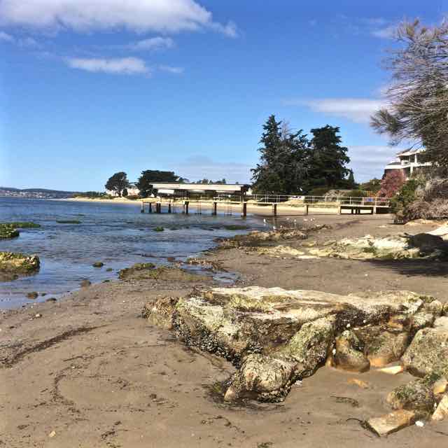
Nutgrove Beach with Sandy Bay Point at the far end.
Two beaches radiate from unassuming Sandy Bay Point: Nutgrove to the north and Long Beach to the south, with green and leafy Sandown Park fanning out behind the point. The Sandy Bay Sailing Club is prominent above the dunes. It, along with its parking area inhabit the dunes and the area behind them. Last summer a creative French traveller parked his colourful van here and settled in, just one of the travellers passing through in their camper vans, their tenures normally much briefer affairs.
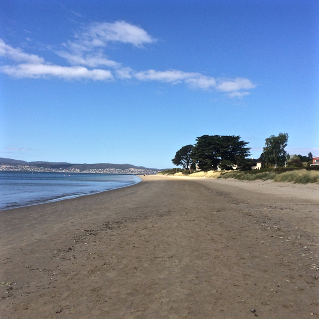
The day I walked from Lords Beach to Sandy Bay Point I had Hobart’s early regattas and yacht races in mind along with that first horse race (see post on Nutgrove). In the early years of the colony Nutgrove was a wider beach and on this particular day I got a clue as to what it had once been like because as I walked around the Red Chapel cliffs and found the little cove the birds have been gifted I saw that everything about the beach was different. It was wider than I think I’ve ever seen it before and at Sandy Bay Point, where beach access at high tide is often not possible except over the fragile dunes, there was a surprisingly generous sweep of sand. I was so deeply absorbed in the past that it was almost unsettling that no horses hurtled around that corner as they did back in the early 1800s when local accents were different, dresses were long and riotous parties were a part of the regatta and racing celebrations – to the point that Sir John Franklin (of North West Passage fame and, locally, as the Governor) put a stop to the regattas below Government House because there was too much unruliness and litter. James Kelly, chair of the Regatta committee (who’d circumnavigated Van Diemen’s Land and discovered Port Davey), moved it to Chaffey’s Point (today’s Wrest Point). Mr Chaffey made a killing at his pub – and Sandy Bay Point featured more strongly in the races.
Wide enough to race horses
Sandy Point, back in the 1800s, had smuggling coves to the right of it and smuggling coves to the left. The little rivulets – Waimea, Maning and Lamberts, for example, provided access routes for getting smuggled grog up into the bush but the inns along the coastline were conveniently located for receiving rum and other spirits from the ships anchored offshore too.
One of these ships was the Thomas. One dark night in 1833 Captain Hanley anchored off Sandy Bay. He’d cut deals with the smugglers, so his pockets were full and likewise the longboats were all weighed down as the smugglers rowed back into the coves.
Later that night the Thomas went up in flames and the fire raging on the river lit up the sky, mesmerising those awake on shore and ‘looking almost splendid’ according to an onlooker. Hanley and three other crew members were the only ones on board at the time. They jumped into a longboat and set off for the shore but because the fire seemed contained to the stern they returned for another look, while two boats, the Mary and the Stakesby came slowly to their rescue. As they stood near the poop the fire reached the magazine and their was a massive explosion. In the little farm houses along the coast people asleep in their beds shot upright and got to experience an unanticipated fireworks night. Somehow the sailors escaped with their lives.
‘At eight o’ clock on the Sunday morning the dying Thomas was towed burning to nearby Sandy Bay Point where she grounded in about five feet of water and continued burning through the Sabbath with crowds flocking to Long Beach to view the spectacle. (Goc, 1997).
Suspicion over who’d started the fire swirled through the community and over the ensuing days what was left – casks of rum and casks of salt floated on the water, easy pickings for the opportunistic.
The Thomas stamped its presence on the point, predating the ‘boat park’ with its pirate ship in Sandown Park. In fact, in 1880 ‘H’ wrote ‘…anyone walking now along the beach at high water past Murdoch’s fence would hardly believe that the ship Thomas which was wilfully burnt about 1831, and was beached at Sandy Bay Point, was available to ramblers at low watermark. Many a time I have with my young companions mounted the ribs of the old ship, which stood on the sands, a place which to get at now would be in 20ft water.’
It’s a whodunnit without an answer. The fire may have been caused by a smuggler dissatisfied with his deal, a mutinous crew member or, for all we know, the captain himself.
Source: Goc, N. 1997. Sandy Bay: a social history. Gentrx Publishing, Hobart.
Sandy Bay Sailing ClubRounding Sandy Bay Point
Approaching Sandy Bay Point: the path over the eroding dunes
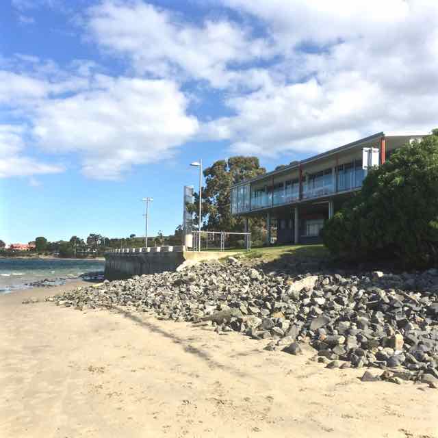
Prossers Restaurant: a prime position on Sandy Bay Point. Rocks shoring up the eroding beach, usually below waterThe Sandy Bay Point walkway to the beach
View of the Casino from the Royal Yacht Club of Tasmania
Puzzling over Sandy Bay’s earlier coastline I browsed books and clicked my way through archival images and concluded that for thousands of years Wrest Point had more delicate proportions. Before the Mouheenener were forced off their land in 1804 it would have been used as a landmark, a camping spot, a pantry and a kitchen, with Lamberts Rivulet on its northern side creating a diversity of plant and marine life – that is, if that rivulet hasn’t been diverted. I checked the stormwater map. Drains and rivulets join up but I was reasonably confident it was entering the river in much the same spot it always had.
People were possibly born on this point of land and they certainly died here, hung for misdemeanours on Gibbet Point, as it was known in the early days of settlement, because it was far enough away from Sullivan’s Cove not to cause offence but still a visible reminder of the ultimate punishment.
These days bitumen and the casino weigh down those old sorrows and more besides, because apparently the Sandy Bay Station was in this general vicinity, the home from 1838 of a cohort of homesick Canadian political prisoners, rebels in an uprising, the Battle of Prescott. Their voyage out from Quebec on the Buffalo took a hellish four months (sickness, injury, fear and hunger) and when they arrived, swaying and staggering on their sea legs, they were, that very day, forced off to build Sandy Bay Road. The station was rough – a circle of basic huts – and their provisions were meagre. But they managed to write diaries and when the Governor, Sir John Franklin, who later died searching for the North West Passage, came visiting, one of them wrote this:
He made a very edifying speech to us, in which he was pleased to say that we were very bad men, very bad, indeed; and intimated that we all deserved to be hung. He said we had been sent there for one of the most aggravating crimes, putting much emphasis on the word ‘aggravating’, and, at the same time, as if unwilling to look us in the face, rolled his eyes up to heaven, like a dying calf, if I may be allowed to use a a comparison suggested by my former business…’ (Captain Daniel Heustis, a butcher prior to exile).
Thomas Chaffey, who owned the point, tried to help them escape. He’d come out to the colony aged 45, having narrowly missed being hung for robbery and having served time on Norfolk Island. His land extended from the point up the slopes of Mount Nelson but he and his wife Maria (a Lady Juliana convict with a sentence for shoplifting) built a modest stringybark cottage on what then became known as Chaffey’s Point. The couple and their seven children had a front row view of executions for several years and after that a foul smelling try works may have been established on the point (Goc,1997). Thomas’s son, William, built the Traveller’s Rest hotel on Chaffey’s Point. Later, a hotel, the Wrest Point Riviera, was built there and in 1973 the Wrest Point casino took its place.
The Boardwalk at the Casino traps the sun and is built over the water. For a brief period one summer I liked to walk the local beaches then go there for a coffee, the papers and a view of the yachts. This was before we actually bought a boat and I could elevate that experience to coffee on board wherever on the river I chose to have it. (Today it was mid river, the water quiet, the breeze minimal and five dolphin in a tight pod swimming slowly by.)
The point has been the site of much happiness and sadness and these emotions are still very much entwined in terms of the current business of tourism and gambling. As for the land itself, it’s been beefed up, extended, and when you sail by you can see pipes entering the river beneath the casino as well. Although the cormorants and seagulls hang about on the rocks close by, the contamination from the hotel and the marina has to be detrimental. It’s no place for swimming and no place to feast on the stoic molluscs that survive there but apart from all that, it’s an iconic local landmark.
One Christmas when I was new to Hobart, my friend and I rode up the mountain, a long slow ride that kept me at eye level with some of its passing features and wobbling as I got distracted by the silencing view beneath us. The plants, the water dripping through the sliced soil at the road’s edge, the tall forests of eucalypts and rainforest species, the fragrant air and then in the alpine zone the sculpturally stunted snow gums and cushion plants, were hard and breathless work to get to know.
A rest at the summit, the chill, the distant view of the South West, the disorientating landscape of peninsulas and islands, most of south eastern Tasmania spread out about us, and then the exhilaration of sweeping back down its long flank on the narrow road, all the way back to the city.
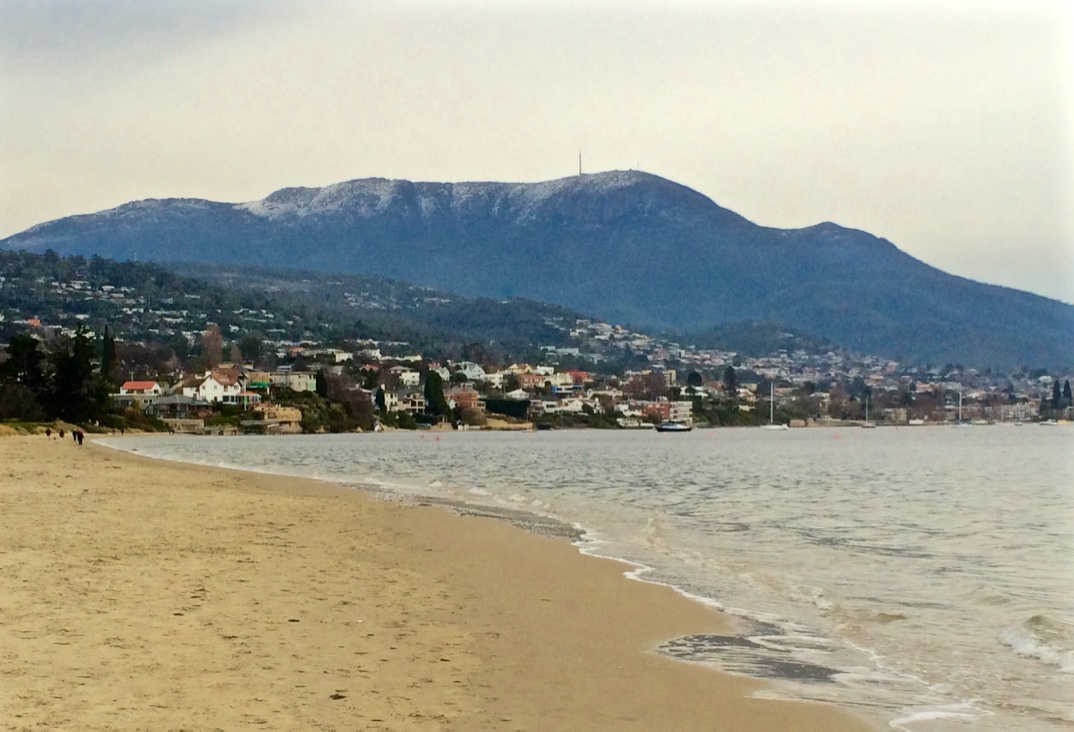
The first beaches I’m exploring lie beneath the mountain, the usual term Hobartians use to name it up but when one day not so long ago I turned on to the summit road and saw the new kunanyi / Mt Wellington sign, I thought, quite simply, ‘YES!’
I’d almost forgotten Uluru was once Ayer’s Rock and frankly, for a massive mountain to be bequeathed the name of a mere mortal in a distant land, is an archaic notion. The mountain, through the Ice Ages and the Holocene and past the date of European settlement, carried many names (Unghanyahletta, Pooranetere and others), because there were different languages and dialects spoken here but in 2013, at a ceremony on its summit, the government announced its new dual naming nomenclature policy, a late acknowledgement that this land once had other more authentic and richer names than it currently carries.
The mountain rises above the city like Table Mountain over Cape Town and although the foothills disguise this fact, kunanyi is actually the taller of the two. In February 1804, dissatisfied with the initial settlement at Risdon Cove, a small party landed at Sullivan’s Cove on the western shore. In a letter that month the Governor said there ‘there is a run of clear fresh water, proceeding from a distance and having its source in a rock in the vicinity of Table Mountain…’ (HRA 3,1 p 223 Collins to King 29 February 1804). Clearly a similarity between the two mountains, the way cloud snags on their summits, had been noted.
We think 100 years a lengthy span. Kunanyi took the Permian, Triassic and Jurassic ages to achieve its character. Geologists look at it and see a horst. For a sailor or explorer, like George Bass, who noted it in 1798, it’s a most significant landmark. The early settlers appreciated its water but took to soiling it immediately, used as they were to the sewers and drains of cities like London. Kunanyi had been seen as sacred, the relationship non-duelist, totemic, but Europeans put a higher value on utility and took its timber, stone, wildlife, plants and water. Non-duelist myself, I can’t begin to imagine the pain that those clans, pushed out of their own home, felt as they watched the earth they belonged to desecrated so wantonly. Had the new arrivals not been so Cartesian in their perspectives, words like threatened, endangered and extinct would, just maybe, not apply to Tasmania’s natural wealth like it does today.
Mountain fires, floods, landslides, eras, climates and species come and go and despite the recreational, weather and telecommunication structures on its summit, it’s still magnificent, sometimes so solidly present, sometimes ethereal, and occasionally in humid weather, like a dreamtime serpent, a long ribbon of cloud slithers through the valleys and wraps itself around the mountain, creating an atmosphere of mystery.
It has a secret night life, most denizens being nocturnal – the chorussing frogs, the sugar gliders, the wallabies, the boobook owl – and it has a diversity of plants, is criss crossed with paths and rivulets, studded with huts and waterfalls. In 1906 the mountain got a little more breathing space from people when it became a park. When you go walking, its best to be prepared because like so many mountains, it’s wild and can be tempestuous and even today has the capacity to snatch up lives.
This has been a cold winter and most unusually there has been snow on the summit almost every day. I’m looking at those snow flecked cliffs, the Organ Pipes, up at the peak. I know that around the corner The Lost World is also under snow. I’ve been sailing the river and walking the beaches, and making my plans to follow that rivulet whose catchment I live in, (with its tendrils starting above our home, behind it, in front of it and below it) from its accepted source at The Springs down to the beach at Sandy Bay.
And in walking the rivulet, I’ll also be walking kunanyi.