
Frederick Henry Bay: Cremorne Beach to Lauderdale
Walking Swathes of Yellow
There are homes on the low dunes backing Cremorne beach and behind them the small community stretches across the flat land in the elbow between the beach and Pipeclay Lagoon. These reaches of Moomairemener land were first reshaped into farmland by the McCauley family who arrived in 1804 and ran cattle and sheep. They also grew potatoes, barley and beans. These days it’s a small community of permanent residents and holidaymakers; a place unspoilt by the inappropriate development that marrs so many other beachside villages although there is currently a developer who would really like to try. I for one hope this community holds out against greed.
Pipeclay Lagoon
Cremorne benefits from Pipeclay Lagoon, an enclosed, tidal body of water that separates it from Clifton to the south. I discovered, when I kayaked it, that it is shallow and that I’d chosen the perfect way to enjoy its serenity. There are oyster farms here and along its margins there are 45 ha of saltmarsh wetlands, protected to some extent by coastal reserve and the attentions of the Wildcare Deslacs Group, but also threatened by changes in tidal flows, habitat disturbance, unmanaged tracks and roads, ditches and litter.
One of the first farms on the banks of the lagoon was Waterloo Farm, owned by Captain Busby and his wife Mary. When John Morrisby bought it from Mary he developed orchards of apples, pears, apricots and cherries and grew peas and root crops between the rows, enriching the alluvial soils with seaweed. There’s a rare eucalypt (Eucalyptus Morrisbyi) that grows in this area and it takes its name from this farming family, who eventually sold, the subdivided land along the waterfront and lagoon giving way to weekenders.
Today, on the Cremorne side of the lagoon there is a narrow road squeezed between backyard fences and the shore. It runs down to a tapering of beach beside the lagoon’s channel to the sea. Four dolphins came through this channel earlier this year and stranded but for walkers it’s a good place to begin exploring the short, narrow beach.
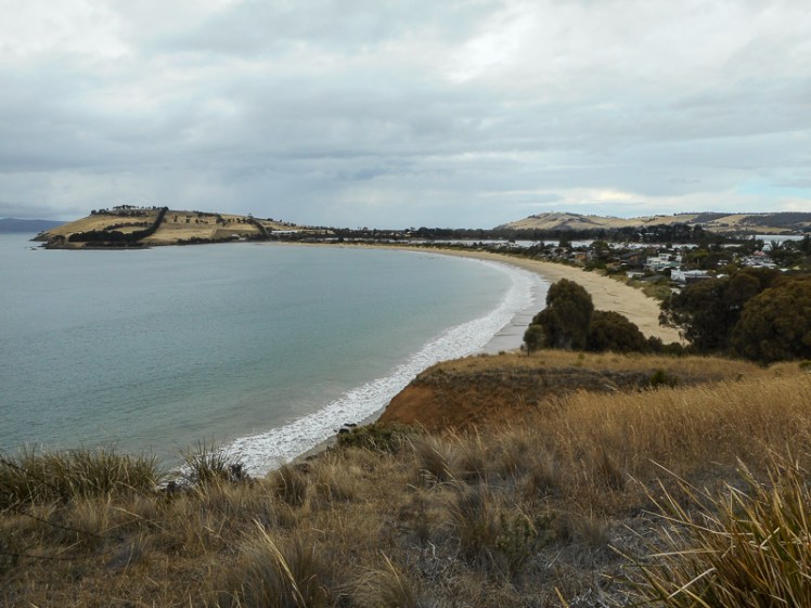
Cremorne Beach (T405)
The beach has a domesticated feel because of the houses on the low dunes, but this is deceptive. When there are storm surges such as there were in 2010 and 2011, the waves have been known to undercut sections of the dunes and there have been a number of dramas at sea off this coastline.
Cathy and I came to Cremorne hoping to find a track we thought might exist at the northern end of the beach. It was a cold day, the tide was out and rain threatened but quite quickly we had walked the kilometer or so along the sand. Ahead of us was the steepish, yellowish slope of Calverts Hill, much of which was owned in the early days of the colony by Elias Grimsey, whose neighbour for a while was the Rev Knopwood’s adopted daughter, Elizabeth.
Calverts Hill and Cremorne North (Beach T404)
We quickly found the track and walked quite easily across hillsides of tall yellow grass, coming across a small cove about ten minutes into the walk. Beach T 404 is a short 50m pocket beach that looked to be mainly cobbles trapped by the cliffs that are some 30m high. It’s also only accessible from the sea and apparently at times sand fills it to form a low tide made terrace.
Most of Calverts Hill is reserve, perhaps to protect the endangered Eucalyptus morrisbyi which is in decline, but fortunately there are people who care.

For a while we followed a fence line and then we descended down to the rocks and most of our walk ended up taking place just above the waterline as the path curved around one undulating hillside after another. We idled along, discussing the rock formations we encountered. The sea was quiet and rain was visible in the distance. There were good views over Sloping Island to the Tasman Peninsula.
We passed five pied oyster catchers standing quietly on the rocks. We passed a couple of pacific gulls and then a shag standing very still on a pole, imbuing the mood of the day. It was hard to gauge how far we still had to walk.


Mays Beach (T403)
I was keen to reach Mays Beach because I had only ever seen it from the top of Richardson’s (aka Nobs) Hill and from there it seemed unattainable down at the bottom of the steep slope, separated from the road by private land, but as we rounded Calverts Hill on our walk the land flattened out and there before us was the beach, occupied just then by a flock of about twenty plovers.
We were fascinated to discover a small number of houses in the bush behind us, but they’re so tucked away that we couldn’t easily discern any driveways or even a road and as we crossed the beach we puzzled over their means of access – down Richardson’s Hill or from somewhere to the south?
This walk had taken about 2.5 hours and we were yearning for lunch and racing the approaching rain. Still, while Cathy explored the hillside looking for the path, I walked along the kilometre long curve of beach, crossing a spine of rock that divided it into two sections to its conclusion at Mays Point, where there is a right hand break.

Richardson’s Hill
The hill is 79 m high but the good news is that the track is well made and links the beach to the top of the hill where the private road begins behind a gate. We literally ran up it to reach the car we’d had the foresight to park at the top. We had finished just in time – the temperature was dropping and the rain slammed down on us just as we got there.
One of us was digging about frantically in pockets but to no avail. The car and its keys were separated by the distance of our walk. All thoughts of lunch in a cosy café faded. Wildly we surveyed the landscape beneath us for a shortcut back to Cremorne but faced with what looked like a lot of private land we didn’t like our chances and so we set off back down the hill at a trot, laughing over our misadventure.

Further reading: The Cremorne community website
