Bays of Dismay 4: Storm Bay – a threatened seascape

Iron Pot the reef and Bruny Island
Storm Bay viewed from the South Arm Peninsula

Greed’s Heavy Footstep

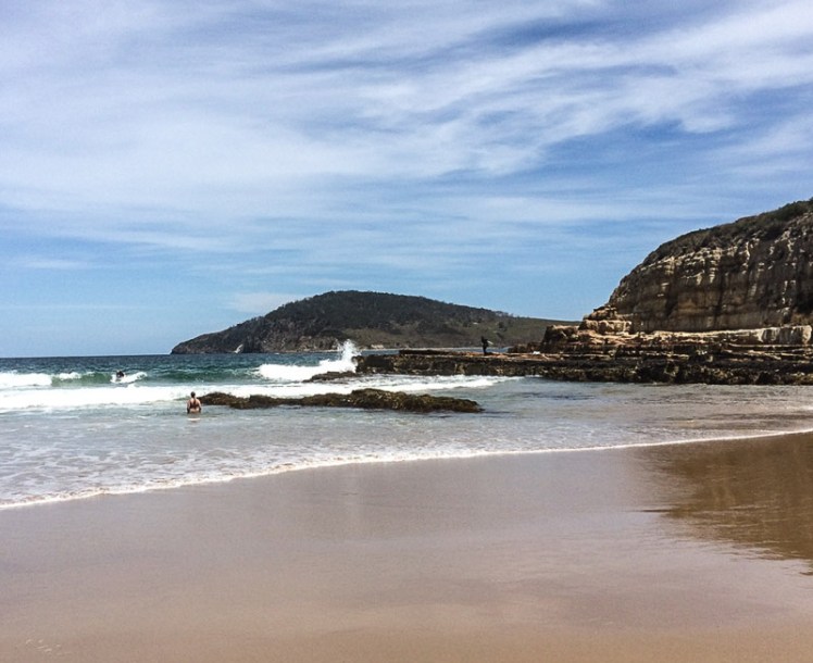
The view from Goat’s Bluff is splendiferous and uplifting, but it’s a threatened vista because the toads are coming.  I didn’t know if such a term (threatened vista) for endangered beauty existed but then I found literature on seascapes and this, right here on a Tas government site:

‘The condition of scenic landscape values is important for Tasmania for a variety of reasons… landscape values often have an association with environmental and natural resource values – the values that people appreciate in a landscape may often also be important ecologically.’

Tasmania. Dept of Justice. 2003. State of the Environment report recommendation 2.9: Scenic and Landscape Values.

And the report goes on to recommend that ‘… scenic landscapes and areas of consistent and recognisable landscape character be recognised in local and regional strategies in relation to beneficial values including  natural resource management; open space and recreation; vegetation management; catchment management; and coastal management.’

Which brings us to the messy issue surrounding Storm Bay

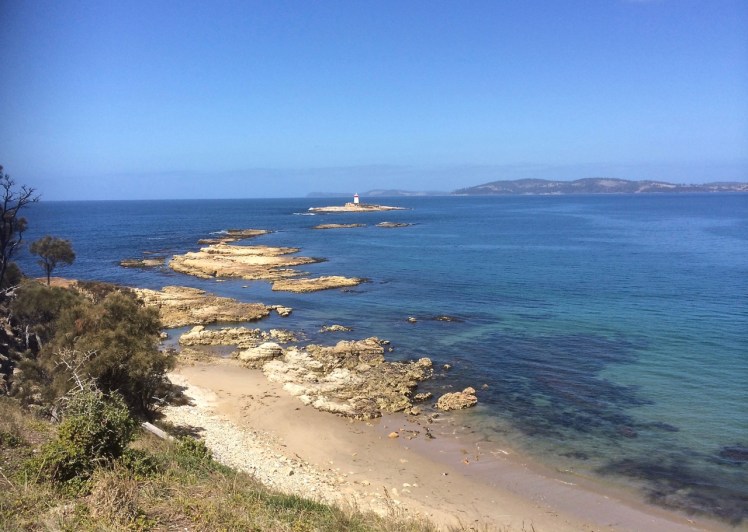
Storm Bay is bound by North Bruny Island, South Arm Peninsula, the Tasman Peninsula and the tip of the Tinderbox Peninsula, which means that there are any number of brilliant perspectives from which you can view this tempestuous bay.

Storm Bay.png
Google Earth image of Storm Bay

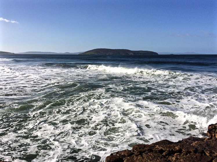
It’s the wilds – right there, where the Derwent River and the D’Entrecasteaux enter it in company and sometimes a gale blowing across the bay can bring that sense of the menacing wild right up the river and into the city.

Storm Bay has a few anchorages along the exposed coastline of Bruny Island for yachts seeking sanctuary from foul weather.   Samos has hung out in Bull Bay off North Bruny enjoying this environment distinct from the river, where the movement of the swell and the surf hold warnings and the feeling of being out here is unique from the river and Channel.

Let’s Not Forget the Voiceless

It’s not just people who are vested in the bay. It provides feeding grounds for the migratory shearwater and other shorebirds and seabirds. It is traversed by dolphins and whales, penguins and seals. Life flourishes on its reefs and I hope you’ll agree that seaweeds have a right to the good life too.

Storm Bay is the magnificently scenic entry that stops people’s hearts when approaching Hobart by sea, the you and me as well as those Sydney-Hobart sailors and passengers on cruise liners.  And rounding the Iron Pot, as you sail down the Derwent marks the point, both mental and physical, at which you finally feel you are sailing the ocean, albeit coastal.

It is the aquatic commons of the whole glorious multiplicity of us  and its moody beauty is deeply loved. Even on a fine day you know its mood can change in an instant and with too much sail out you are quickly humbled.

Goodbye to All That

Storm Bay is about to change into an industrial zone. The three Tasmanian fish farming companies – Tassal, Petuna and Huon Aquaculture – are encroaching massively on our aquatic commons and while their heady expansion plans are good for the economy in the short term, the public’s interest and that of other sentient and non-sentient communities stand to be sacrificed by government complicity. There are fish farm leases planned for Storm Bay and they’ll be visible over vast distances, all around the lovely shoreline. The relaxing high and sense of connection that Nature gifts us will give way to further despair.  The scenic vistas will be destroyed.

image001

Hello Solastalgia

We have already lost grand views and the sense of desolation many of us feel when we try to navigate through multiple leases or view bays and waterways taken up by ugliness reflects the all consuming loss felt by the people we replaced when their hunting grounds and sacred sites became no go areas and disappeared under pasture and houses. This time, buried in that same greed and disdain lies self mutilation.

Navigating Storm Bay, especially in gales, will become more dangerous. The plastic pollution, the exceeded nitrogen caps and the damage to reefs that the companies have caused in the D’Entrecasteaux Channel and Macquarie Harbour will happen here too. These companies are bringing along that same disdain for the commons, those same bad habits. For example, so often they’ve been advised that when towing pens they need markers on their lines because the distance can be such that other vessels could accidentally cross between with dire consequences. This week, in the Channel, we again noticed a tow underway without markers. It’s disrespectful, it’s frustratiang and it’s downright dangerous.

The weight of the farms on top of visible climate change impacts worries a lot of us down this part of the world. After all, we are a climate change hot spot.

It’s beyond disappointing that the companies said they were heading offshore then chose to plonk themselves down in this significant coastal bay – to plonk themselves down in the magnificent entrance to the Derwent. And rather than deep ocean – just take a lead from this, guys – they’re heading for the coastal zones of our offshore islands, those last bastions of the birds. There, amongst sparsely habited islands they can get away with environmental savagery. But on King Island some are beginning to cry foul.

In the future, Petuna’s leases just south of Betsey Island are going to marr the Goats Bluff view. Tassal’s will probably be visible too. You’ll see pens from Bruny and that’s why the locals are concerned there too. Friends of North Bruny, the Bruny Island Community Association and the Bruny Island Environment Network have joined forces to call for a moratorium on this alarming expansion of fish farms into Storm Bay.

Almost everyone wants these companies to really be clean and green and to excel at that, as opposed to dirtying the waterways they’ve encroached into. But that means upping their standards and appreciating the limits to growth, respecting the public and their customers.  Unfortunately, it still doesn’t seem to be something they’re in any rush to do.

We only have one planet. Let’s stop hampering its efforts to nourish us.

For more information:

Royal Yacht Club of Tasmania. [2016] Salmon Farming Proposals in Storm Bay

DPIPWE. 2017. Sustainable industry growth plan for the salmon industry. Hobart.  The Dept.

Guarnieri, G et al. 2016. The Challenge of Planning Conservation Strategies in Threatened Seascapes: Understanding the Role of Fine Scale Assessments of Community Response to Cumulative Human Pressures. PLOS. https://doi.org/10.1371/journal.pone.0149253

South Arm Peninsula: Goat Bluff, a fundamental question and a couple of secrets

Goats Bluff and Betsey from Calverts (1 of 1).jpg
Goats Bluff and Betsey Island from Calverts Beach

… what is beauty? This is one of the most fundamental questions, it is not superficial, so don’t brush it aside. To understand what beauty is, to have that sense of goodness which comes when the mind and heart are in communion with something lovely without any hindrance so that one feels completely at ease – surely, this has great significance in life; and until we know this response to beauty our lives will be very shallow. One may be surrounded by great beauty, by mountains and fields and rivers, but unless one is alive to it all one might just as well be dead.

~ J. Krishnamurti

img_3984-2
A Google Earth image of  Goats Bluff to the north of Betsey Island. Calverts Lagoon behind Calverts Beach (right) was largely dry when this image was taken.

On Being a Goat

It may seem strange that I’ve included Krishnamurti’s quote at this point in my blog, because the bluff is unassuming, easy to hurtle by without noticing, and yet it has a certain sense of poise gifted by its location in the landscape between two capes so that, had Krishnamurti, a great nature writer, found his way here, I’m sure he would have taken his seat and looked out at ‘all the marvellous earth’, the hills and the valleys interleaving themselves, and perhaps, while contemplating this magnificent coastline he might also have reflected on human nature – how we are so often goats, with at times, a certain poise, when we make the effort.

Those who appreciate beauty come here at night to star gaze and to wonder at the auroras.  In daylight hours, as the sky’s moods play out over the landscape, colours shift transferring the mood of the sky.  At this  junction of ocean, land and lagoons the biota is rich, the birds are various, the native coastal vegetation still reasonably intact. Surfers carve the breakers; below the cliff to the east is a break called Rebounds. Goats and Wedge are breaks to the west.  And from these 30 m high sandstone cliffs you can walk west along Hope Beach (aka Roaring Beach) to Cape Direction or you can go east down Goat Bluff’s flank to Calverts Beach for the walk to Cape Contrairety, or angle slightly inland to circumambulate Calverts Lagoon, binoculars around your neck, field guides in your rucksack.

Goats Bluff cliffs (1 of 1).jpg
The bluff’s ramparts with Betsey in the distance

The bluff also provides access to the north. Just cross the road and go west along the isthmus – but think seriously about this – the birds love this thin strip of beach beside the bitumen so it’s unkind to intrude.  Perhaps rather choose the meandering track (far more rewarding) along its eastern shore.

Or simply play it like Krishnamurti and  make your mind like the sky by lingering on the bluff with its sense of poise drawn mostly from the fact that it is the divide between the Arm End beaches and the sweep of coastline to the east.

In other words, don’t think for one moment that Goat (also known as Goats) is an isolated bluff simply there as a carpark, or a dislocated remnant scrap of reserved native vegetation. The road behind assumes more importance than is warranted. Instead, imagine that you are Nuenonne, that slash of bitumen not there yet and see instead Colin Springs Hill descending gracefully down to the bluff’s sandstone rampart, uninterrupted.  Before you there’s a valley, drowned by the ocean that extends down from that rampart and out to Betsey Island, with a dune trapped lake to your right behind Hope Beach, the drowned valley that is Ralphs Bay behind you to the north, a pooling of water in Calverts Lagoon and Pipe Clay Lagoon at Cremorne behind you to your left.

Goats Bluff.  A small band of Nuenonne.  Shearwaters wheeling on the night sky, and then the aurora.

Goat’s Secret, Hope’s Secret and Betsey’s Secret

Goat Bluff has two secrets.  

The first is a beach (T412 (Short, 2006)).

Short describes it as ‘a 60 m long pocket of rocks and sand set in a gap in the centre of the bluffs and immediately below the lookout. The beach consists of high tide cobbles and boulders against the base of the cliffs, then a sandy 100 m wide bar with rock outcrops that fill the gap. Waves are lowered to 1 m at the bluff owing to sheltering by the island and rocks and break across the bar with a weak rip usually flowing out against the western rocks.’

He says there is no safe access to this beach. To try would be dangerous.  So please don’t.

I was surprised to discover another secret on the On the Convict Trail blog: ‘Nearby [to Piersons Point] Goat Bluff was also the location of further underground tunnel systems [associated with the Derwent’s system of battery defence].  But Goat Bluff isn’t near Piersons Point, which is on the western side of the Derwent’s mouth (although distance is relative, I guess) and so I was sceptical until I saw this fact repeated on the South Arm History site.  The Fort Direction page by Maurice Potter states ‘at Goat Bluff there are still the remains of underground trenches that were built at that time’ [WWII] and I also discovered on this page that ‘as many will remember, most of the beaches and the hillsides of South Arm were covered with barbwire entanglement and this remained so for some years after the end of war.’ (Potter, n.d.)

Betsey’s Secret

Sitting on the bluff contemplating the landscape you might naturally suppose that Betsey Island is made off the same stuff as the bluff, but you would be wrong.  Black Jack Reef and Goat Bluff are sandstone / siltstone but Betsey declares its difference by being Jurassic dolerite (Leaman, 1999).  It shares another secret with Hope.

Hope has even more compelling secrets

And as Goat Bluff overlooks Hope here they are.

The first is the precise whereabouts of the wrecked ship, the Hope, that gives the beach its name (Leaman, 1999).

The next secret really belongs to the general vicinity near Hope because between Betsey and the Derwent Light mysterious compass deviations first noted by Mathew Flinders are now assumed to be caused by volcanic necks on the sea floor – and according to Leaman (1999) may possibly have caused the Hope to wreck in the first place.

But here’s the best secret.  Eons ago the complicated Derwent entered Storm Bay through the South Arm isthmus, which now blocks it.  The best part of this secret is that it seems to have done so through ‘a gorge [now] filled with more than 200 metres of clay, sandy clay, sand and gravel [that] lies hidden from our view…’ (Leaman, 1999).

Hope Beach from Goat's Bluff.jpg


A mountain.  A river. A bluff.  They may seem so enduring, but I think all nouns are simply verbs in disguise and everything a process.

IMG_3932

Sources:

Leaman, David. 1999. Walk into history in Southern Tasmania. Lehman Geophysics, Hobart

Short, A.D. 2006. Beaches of the Tasmanian coast and islands. Sydney University Press, Sydney.

South Arm: Betsey Island: mountain in the water with many names

Betsey Island viewed from Mount Nelson.jpg
‘The Mountain in the Water’ viewed from Mount Nelson

Who are you really, Betsey Island?

Betsey is a hump of island, the largest of the three in the Betsey Island Group and although it is visible from a number of Hobart suburbs, because of the hilly landscape and the peninsulas that surround the city, it often disguises itself as just another bump in the landscape.  Like Tinderbox Peninsula, its reefs were shaped by volcanic activity and on three sides cliffs rise steeply.  It has a small pebbled beach, Black Jack Reef lies between Betsey and Hope Beach and if Tinpot Island, also a member of the Betsey Group, is the sentinel for the Derwent River, then Betsey Island in Storm Bay is a sentinel as you sail towards Frederick Henry Bay.

2 Hope Beach betsey and little betsey.jpg
Betsey Island and Little Betsey Island viewed from the Hope Beach reef

Sailing Betsey

I was pretty excited the first time I took part in one of the 29 nm races from its start at Castray Esplanade in the Derwent River, out around Betsey Island and back to start on a Trad 30.  It remained a favourite race because it left the confines of the river and took in  a stretch of coastline I walked but rarely sailed.

It was on race that I discovered that Betsey Island had a tiny companion, Little Betsey Island, tucked under its southern shoulder and that this little island trails a reef too.  On the lovely Birngana, we came in tantalisingly close beneath Betsey’s eastern cliffs on one race (seabirds swirling above), seemed just behind Hope’s breaking waves on another and, each time I’ve done this race, it’s proved long enough to glide to a halt  on a mirrored surface in the river, to enjoy a reach exhilaratingly heeled, to watch the sea state change time over time with the arrival of catspaws or wild gusts.  Spinnakers up, or reefs in, maybe romping back up the river or stuck at the back of the fleet, the sailing on Birngana was always convivial, the rounding of the two Betseys full of curiosity and wonder, and the fun of the race always continued through drinks and snacks back in the berth.

Confused Identity

Names come and go and play a role shaping  identify.   For the longest time Betsey Island is understood to have been called Teemiteletta or Lore.by.larner.wa.  There is a record of both names, presumably given by different tribes – the latter name seems linked to the Moomairremener, who had a myth about a group of girls who went across to Lore.by.larner.wa to enjoy themselves, but were chased by some men.  To escape them they leapt into the sea and a spirit, Rageoropper, who judged in favour of the girls, turned the men into rock, while the girls swam back to rejoin their tribe. (Go girls! #metoo.)

 Those name givers that made their way over the water to the island as wild swimmers or in their bark canoes left memories of their journeys by way of scatters of shell and stone.  They’d have been seeking mutton birds, shellfish and penguin eggs.  Bruni D’Entrecasteaux, the French explorer, called the mountain in the sea Willaumez Island after Jean Baptiste Willaumez, who was on board the  Recherche with him.

In the 1800s the British came with a heavier footstep and in short succession the island gained a string of new names – Lady Franklin Island, Franklin Island and these days Betsey Island.  It’s possible it may have been named after Betsey, the daughter of Sergeant MaCauley and his wife Maria, who farmed in the Clarence area and were friends with the Reverend Knopwood.

The island was still being used by the Moomairremener in the first years though, because in 1804 an aboriginal man was taken from the island into Hobart and the governor ordered him to be dressed in European clothes.  Luckily he was able to escape that night (Nicholls, cited by Clarence City Council).

In 1814 another group of aborigines were found sitting around a fire on the island and encouraged to visit Hobart.  Again they were inspected by the Governor and given clothes.  After being offended by a local it is unclear whether they were taken to Bruny Island or drowned as they tried to reach it.

Betsey’s Many Uses

In the early days of the colony two convicts were placed there to signal when a ship was sighted, either by firing a gun by day or lighting a fire by night. It was used  as a lookout by whalers.

It also became the home of the offspring of  five rabbits who were on the First Fleet to Australia.  In the 1820s, when the island was bought by a Mr James King, he built himself a stone house, took his water from a couple of fresh water springs and set about  breeding rabbits for the Chinese fur trade, a profound shock to the island’s ecosystem.  His endeavours were quite successful but he sold the island on for 470 pounds to Captain John Bell and Mr Crombie, who continued this business … and while the men sold rabbit pelts to China, the rabbits nibbled steadily through Teemiteletta’s pelt.

By the 1840s the dishevelled island had been bought by Sir John and Lady Jane Franklin for 910 pounds and one of her many creative notions was to establish a botanical garden or game reserve there.  The plan never came together and the island was left to itself, although it was visited occasionally by fishermen and was the temporary hang out of  a handful of deserters, feasting on rabbits and birds, no doubt, while they patiently waited for their ship, the Cicero (American) to leave Hobart.

Then, in The Mercury of 24 May 1876 there’s this intriguing report:

Land Slip at Franklin Island.

A letter received by Mr. J. W. Graves from’James Alexander, better known as ” Old Alick,” who has for some years resided on Franklin Island, recorded an interesting occurrence that occurred there on the 18th inst. Alick states that himself and the boy who resides with him were at the back of the island about four o’clock in the afternoon, when they had a narrow escape of being buried alive.
They had just crossed the flat ground at the back end of the long hill, when the land began to move steadily, ” the same as a ship being launched.” In a few moments an immense mass of earth,’ the best piece of land on the island, fell into the water, leaving, as the writer describes it, “a great gulf.”
Alick seemed very much concerned about it, probably from an idea that at any moment the whole island may disappear in a similar manner.’ He says it does not look like the same island, and wants Mr. Graves to go down and see it. Franklin Island, as is well known, was named after that noble lady who passed away last year;  but the native name of it was Teemiteletta, or, mountain in the water. It was given by Lady Franklin to the people of the colony, and has always been looked upon with great interest. It would be a thousand pities if it was swallowed up in the Derwent.

The Real Owners

Forget the affairs and acquisitiveness of men.  These two islands and the Betsey Reef are now part of a 176 ha nature reserve which somewhat protects its natural owners.  On its rocky dolerite cliffs, with outcrops of sandstone, on its scree slopes, sedgeland and saltmarsh life exists.  White’s skink and the she-oak skink live here.  Birds add colour and music to the open eucalypt woodlands and burrow into the sandier soils but there is only one mammal – the silver-haired rabbit  – that erodes Teemiteletta still – well, at least up until 2002 – but let’s hope the Tasmanian Parks and Wildlife Service has rectified this by now.

In  1985 and 1999, when Nigel Brothers and David Pemberton surveyed the island there were over 15,000 little penguins living there, joined in summer by approximately 150,000 shearwaters.  The penguins, arriving and departing the island risked their lives because both professional and recreational fishers set nets just offshore. It is  outrageous that nets were not been banned decades ago.

232 black-faced cormorant couples also lived on Betsey then.  Kelp gulls were outsiders – only 3 pairs and 11 individuals set up home here.

They saw a white-faced heron.  A pair of sea-eagles had a nest in the eucalyptus forest but wedge tailed eagles also had a presence.  Other raptors included swamp harriers and the brown goshawk and in the Eucalyptus globulus woodland there were spotted pardalote, noisy miners, various honeyeaters, the grey butcherbird, the forest raven, the nankeen kestrel and silvereyes.

The thunder of the human footprint also exists in the weeds that limit Teemiteletta’s life giving generosity.  Boxthorn and Cape Leeuwin wattle restrict the natural habitat available to the amazing diversity of species this small 175.13 ha island supports.

Beautiful Graveyard

I didn’t know when we sailed by Betsey that beneath us lay wooden and metallic corpses, now bejewelled with marine flora.  Old ships need graveyards and since 1916 they’ve been dragged out to Little Betsey Island to create vibrant underwater gardens frequented by divers.    Two of the ships are flattened 1930s freighters now lying off Little Betsey Island reef and a number of harbour vessels lie out to the west.  There’s even a section of Hobart’s old pontoon bridge there.

(For more about the scuttled ships see these links:  Shipwrecks of Tasmania , Tasmanian Scuba Diving Club and the Marine Life Network

Black Jack Snaffles a Ferry

Black Jack Rocks, closely associated with Betsey Island snared a nautical prize in 1994.  Incat, Hobart’s ferry making success story, had been contracted to build Condor 11, a 78 m vessel, but on its trial in Storm Bay on 8 October 1994, there was a navigational slip up  and in the darkness of the night the ferry rushed a full boat length on to the semi-submerged reef – and stayed there for a good two months, its stern and portside hull clear of the water, while repeated rescues were attempted until finally it was freed.

Fish Farms

Change is coming again to the mountain in the sea.  Conscious of the damage done to the D’Entrecasteaux Channel and Macquarie Harbour, fish farms are moving out into Storm Bay.  The proliferation in this area will have a negative environmental and recreational impact on the bay and the island.

Sources:

Brothers, Nigel; Pemberton, David; Pryor, Helen; & Halley, Vanessa. (2001). Tasmania’s Offshore Islands: seabirds and other natural features. Tasmanian Museum and Art Gallery: Hobart.

Clarence City Council.  Aboriginal people and early European activity. n.d.

Clarence City Council.  2002? Early settlers (pdf)

Donnelly, Area.  Bunnies by the billions thanks to one gun-loving Englishman.  The Daily Telegraph January 12, 2016.

HISTORY OF BETSY ISLAND. The Mercury (Hobart, Tas. : 1860 – 1954). Hobart, Tas.: National Library of Australia. 14 October 1913. p. 4. Retrieved 5 January 2016.

Tasmania. Parks and Wildlife Service. 2002.  Small South-East Islands Draft Management Plan 2002, Hobart.  

Textual Silence Project. 2014. A brief history of Betsey Island

Wickham, Mark. 2005.  Entrepreneurship and the management of innovation in the global marketplace: the Incat story. The Management Case Study Journal Vol.5 Issue2 Nov 2005: pp83-93